Mount Pleasant Township, Wabasha County, Minnesota

Last updated

Mount Pleasant Township, Minnesota
USA Minnesota location map.svg
Red pog.svg
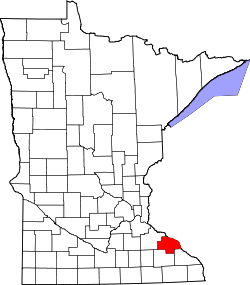
Mount Pleasant Township, Minnesota
Location within the state of Minnesota
Usa edcp location map.svg
Red pog.svg
Mount Pleasant Township, Minnesota
Mount Pleasant Township, Minnesota (the United States)
Coordinates: 44°24′39″N92°21′0″W / 44.41083°N 92.35000°W / 44.41083; -92.35000
Country United States
State Minnesota
County Wabasha
Area
  Total36.0 sq mi (93.2 km2)
  Land36.0 sq mi (93.2 km2)
  Water0.0 sq mi (0.0 km2)
Elevation
1,099 ft (335 m)
Population
 (2000)
  Total475
  Density13.2/sq mi (5.1/km2)
Time zone UTC-6 (Central (CST))
  Summer (DST) UTC-5 (CDT)
FIPS code 27-44620 [1]
GNIS feature ID0665057 [2]

Mount Pleasant Township is a township in Wabasha County, Minnesota, in the United States. The population was 475 at the 2000 census.

Contents

Mount Pleasant Township was organized in 1858, and so named on account of the scenic overlooks from area summits. [3]

Geography

According to the United States Census Bureau, the township has a total area of 36.0 square miles (93.2 km2), all of it land. The township contains two properties listed on the National Register of Historic Places: the 1858 Lake City and Rochester Stage Road–Mount Pleasant Section and the 1880 Patrick H. Rahilly House. [4]

Demographics

As of the census [1] of 2000, there were 475 people, 153 households, and 128 families residing in the township. The population density was 13.2 people per square mile (5.1/km2). There were 158 housing units at an average density of 4.4/sq mi (1.7/km2). The racial makeup of the township was 98.95% White, 0.21% Native American, 0.63% Asian, 0.21% from other races. Hispanic or Latino of any race were 0.21% of the population.

There were 153 households, out of which 49.0% had children under the age of 18 living with them, 72.5% were married couples living together, 3.9% had a female householder with no husband present, and 15.7% were non-families. 13.7% of all households were made up of individuals, and 4.6% had someone living alone who was 65 years of age or older. The average household size was 3.10 and the average family size was 3.40.

In the township the population was spread out, with 34.1% under the age of 18, 9.1% from 18 to 24, 28.2% from 25 to 44, 21.7% from 45 to 64, and 6.9% who were 65 years of age or older. The median age was 32 years. For every 100 females, there were 119.9 males. For every 100 females age 18 and over, there were 114.4 males.

The median income for a household in the township was $40,625, and the median income for a family was $46,071. Males had a median income of $32,500 versus $20,750 for females. The per capita income for the township was $16,591. About 6.3% of families and 9.5% of the population were below the poverty line, including 14.0% of those under age 18 and 6.5% of those age 65 or over.

Related Research Articles

St. George Township is a township in Benton County, Minnesota, United States. The population was 1,153 as of the 2010 census.

Ceresco Township is a township in Blue Earth County, Minnesota, United States. The population was 255 as of the 2000 census.

Pleasant Mound Township is a township in Blue Earth County, Minnesota, United States. The population was 235 as of the 2000 census.

Vernon Center Township is a township in Blue Earth County, Minnesota, United States. The population was 301 as of the 2000 census.

Moorhead Township is a township in Clay County, Minnesota, United States. The population was 442 at the 2000 census.

Vernon Township is a township in Dodge County, Minnesota, United States. The population was 567 at the 2000 census.

Verona Township is a township in Faribault County, Minnesota, United States. The population was 391 at the 2000 census.

<span class="mw-page-title-main">Wacouta Township, Goodhue County, Minnesota</span> Township in Minnesota, United States

Wacouta Township is a township in Goodhue County, Minnesota, United States. The population was 410 at the 2000 census.

Wanamingo Township is a township in Goodhue County, Minnesota, United States. The population was 504 at the 2000 census.

Mayville Township is a township in Houston County, Minnesota, United States. The population was 427 at the 2000 census.

Pleasant Prairie Township is a township in Martin County, Minnesota, United States. The population was 273 at the 2000 census.

Adams Township is a township in Mower County, Minnesota, United States. The population was 475 at the 2000 census. The largest town in the township is Adams with a population of 800 people.

Pleasant Valley Township is a township in Mower County, Minnesota, United States. The population was 308 at the 2000 census. There are no recognized cities or towns and the township is entirely an unincorporated area.

Pleasant View Township is a township in Norman County, Minnesota, United States. The population was 140 at the 2000 census.

Pleasant Grove Township is a township in Olmsted County, Minnesota, United States. The population was 787 at the 2000 census.

West Albany Township is a township in Wabasha County, Minnesota, United States. The population was 439 at the 2000 census.

Freedom Township is a township in Waseca County, Minnesota, United States. The population was 397 at the 2000 census.

Mount Vernon Township is a township in Winona County, Minnesota, United States. The population was 273 at the 2010 census.

Pleasant Hill Township is a township in Winona County, Minnesota, United States. The population was 531 at the 2010 census.

<span class="mw-page-title-main">Mount Pleasant Township, Westmoreland County, Pennsylvania</span> Township in Pennsylvania, United States

Mount Pleasant Township is a township in Westmoreland County, Pennsylvania, United States. As of the 2020 census, the township population was 10,101. Mount Pleasant Township should not be confused with the Borough of Mount Pleasant, which is a separate municipality and comprises the town of that name.

References

  1. 1 2 "U.S. Census website". United States Census Bureau . Retrieved January 31, 2008.
  2. "US Board on Geographic Names". United States Geological Survey. October 25, 2007. Retrieved January 31, 2008.
  3. Upham, Warren (1920). Minnesota Geographic Names: Their Origin and Historic Significance. Minnesota Historical Society. p.  557.
  4. "Minnesota National Register Properties Database". Minnesota Historical Society. 2009. Retrieved February 11, 2018.