Dumfries, Minnesota

Last updated

Dumfries
USA Minnesota location map.svg
Red pog.svg
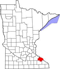
Dumfries
Location of the community of Dumfries
within Glasgow Township, Wabasha County
Usa edcp location map.svg
Red pog.svg
Dumfries
Dumfries (the United States)
Coordinates: 44°20′42″N92°07′13″W / 44.34500°N 92.12028°W / 44.34500; -92.12028
Country United States
State Minnesota
County Wabasha County
Township Glasgow Township
Elevation
791 ft (241 m)
Time zone UTC-6 (Central (CST))
  Summer (DST) UTC-5 (CDT)
ZIP code
55981
Area codes 651 and 507
GNIS feature ID654682 [1]

Dumfries is an unincorporated community in Glasgow Township, Wabasha County, Minnesota, United States.

Contents

Geography

The community is located between Wabasha and Zumbro Falls along State Highway 60 (MN 60). Wabasha County Roads 20, 30, and 86 are also in the immediate area. Trout Brook and the Zumbro River meet near Dumfries. Other nearby places include Wabasha, West Albany, Theilman, Kellogg, and Zumbro Falls.

History

A post office called Dumfries was established in 1894, and remained in operation until 1912. [2] The community was named after Dumfries in Scotland. [3]

References

  1. "Dumfries, Minnesota". Geographic Names Information System . United States Geological Survey, United States Department of the Interior.
  2. "Wabasha County". Jim Forte Postal History. Retrieved August 10, 2015.
  3. Upham, Warren (1920). Minnesota Geographic Names: Their Origin and Historic Significance. Minnesota Historical Society. p.  556.