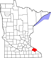
Highland Township, Wabasha County, Minnesota

Last updated

Highland Township, Minnesota
USA Minnesota location map.svg
Red pog.svg
Highland Township, Minnesota
Location within the state of Minnesota
Usa edcp location map.svg
Red pog.svg
Highland Township, Minnesota
Highland Township, Minnesota (the United States)
Coordinates: 44°14′24″N92°7′24″W / 44.24000°N 92.12333°W / 44.24000; -92.12333
Country United States
State Minnesota
County Wabasha
Area
  Total35.8 sq mi (92.7 km2)
  Land35.8 sq mi (92.7 km2)
  Water0.0 sq mi (0.0 km2)
Elevation
1,161 ft (354 m)
Population
 (2000)
  Total471
  Density13.2/sq mi (5.1/km2)
Time zone UTC-6 (Central (CST))
  Summer (DST) UTC-5 (CDT)
FIPS code 27-28952 [1]
GNIS feature ID0664469 [2]

Highland Township is a township in Wabasha County, Minnesota, United States. The population was 471 at the 2000 census.

Contents

History

Highland Township was originally called Smithfield Township, and under the latter name was organized in 1858. The present name is descriptive of the land's lofty elevation. [3]

Geography

According to the United States Census Bureau, the township has a total area of 35.8 square miles (93 km2); 35.8 square miles (93 km2) of it is land and 0.03% is water.

Demographics

As of the census [1] of 2000, there were 471 people, 147 households, and 120 families residing in the township. The population density was 13.2 people per square mile (5.1/km2). There were 155 housing units at an average density of 4.3/sq mi (1.7/km2). The racial makeup of the township was 99.79% White, and 0.21% Asian.

There were 147 households, out of which 46.3% had children under the age of 18 living with them, 71.4% were married couples living together, 4.1% had a female householder with no husband present, and 17.7% were non-families. 12.9% of all households were made up of individuals, and 6.1% had someone living alone who was 65 years of age or older. The average household size was 3.20 and the average family size was 3.58.

In the township the population was spread out, with 32.3% under the age of 18, 11.0% from 18 to 24, 25.3% from 25 to 44, 21.2% from 45 to 64, and 10.2% who were 65 years of age or older. The median age was 34 years. For every 100 females, there were 111.2 males. For every 100 females age 18 and over, there were 121.5 males.

The median income for a household in the township was $49,375, and the median income for a family was $55,139. Males had a median income of $32,232 versus $22,000 for females. The per capita income for the township was $18,747. About 8.9% of families and 8.1% of the population were below the poverty line, including 6.4% of those under age 18 and 24.4% of those age 65 or over.

Related Research Articles

Hawley Township is a township in Clay County, Minnesota, United States. The population was 459 at the 2000 census.

<span class="mw-page-title-main">Timothy Township, Crow Wing County, Minnesota</span> Township in Minnesota, United States

Timothy Township is a township in Crow Wing County, Minnesota, United States. The population was 147 at the 2000 census. The township may be named for its Timothy-grass.

Blue Earth City Township is a township in Faribault County, Minnesota, United States. The population was 454 at the 2000 census.

York Township is a township in Fillmore County, Minnesota, United States. The population was 409 at the 2000 census. York Township borders Forestville Township, Bloomfield Township, Beaver Township, Carimona Township, and Bristol Township.

Yucatan Township is a township in Houston County, Minnesota, United States. The population was 351 at the 2000 census.

Ann Lake Township is a township in Kanabec County, Minnesota, United States. The population was 377 at the 2000 census.

Lynd Township is a township in Lyon County, Minnesota, United States. The population was 471 at the 2000 census.

Pembina Township is a township in Mahnomen County, Minnesota in the United States. The population was 471 at the 2000 census.

Holt Township is a township in Marshall County, Minnesota, United States. The population was 147 at the 2000 census.

West Valley Township is a township in Marshall County, Minnesota, United States. The population was 147 at the 2000 census.

Langhei Township is a township in Pope County, Minnesota, United States. Langhei is a name derived from Norwegian meaning "long highland". The population was 217 at the 2000 census.

Beaver Township is a township in Roseau County, Minnesota, United States. The population was 103 at the 2000 census.

Cedarbend Township is a township in Roseau County, Minnesota, United States. The population was 230 as per the 2000 census.

Deer Township is a township in Roseau County, Minnesota, United States. The population was 92 at the 2000 census.

Dewey Township is a township in Roseau County, Minnesota, United States. The population was 114 at the 2000 census. Dewey is in the 7th congressional district of Minnesota and is represented by Democrat Collin Peterson.

Ward Township is a township in Todd County, Minnesota, United States. The population was 471 at the 2000 census and 474 at the 2020 census.

Pepin Township is a township in Wabasha County, Minnesota, United States. The population was 471 at the 2000 census. The unincorporated communities of Maple Springs, Camp Lacupolis and Reads Landing are located within the township.

West Albany Township is a township in Wabasha County, Minnesota, United States. The population was 439 at the 2000 census.

Freedom Township is a township in Waseca County, Minnesota, United States. The population was 397 at the 2000 census.

Highland Grove Township is a township in Clay County, Minnesota, United States. The population was 304 at the 2000 census.

References

  1. 1 2 "U.S. Census website". United States Census Bureau . Retrieved January 31, 2008.
  2. "US Board on Geographic Names". United States Geological Survey. October 25, 2007. Retrieved January 31, 2008.
  3. Upham, Warren (1920). Minnesota Geographic Names: Their Origin and Historic Significance. Minnesota Historical Society. p.  556.