
Wabasha County is a county in the U.S. state of Minnesota. As of the 2020 census, the population was 21,387. Its county seat is Wabasha.

Olmsted County is a county in the U.S. state of Minnesota. As of the 2020 census, the population is 162,847. Its county seat and most populous city is Rochester.

Goodhue County is a county in the U.S. state of Minnesota. As of the 2020 census, the population was 47,582. Its county seat is Red Wing. Nearly all of Prairie Island Indian Community is within the county.

Kellogg is a city in Wabasha County, Minnesota, along the Zumbro River. The population was 456 at the 2010 census.

Wabasha is a city and the county seat of Wabasha County, Minnesota. The population was 2,559 at the time of the 2020 census. It is on the Mississippi River, near its confluence with the Zumbro River.

Zumbro Falls is a city along the Zumbro River in Wabasha County, Minnesota, United States. The population was 207 at the 2010 census. U.S. Highway 63 and Minnesota 60 intersect in Zumbro Falls.
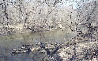
The Zumbro River is a tributary of the Mississippi River in the Driftless Area of southeastern Minnesota in the United States. It is 64.6 miles (104.0 km) long from the confluence of its principal tributaries and drains a watershed of 1,428 square miles (3,700 km2). The river's name in English is a change from its French name Rivière des Embarras due to its mouth near Pine Island in the Mississippi River; the pronunciation changed from [dez‿ɑ̃.ba.ʁɑ] to. The Dakota name for this river is Wapka Wazi Oju, having reference to the grove of great white pines at Pine Island.
West Albany is an unincorporated community in West Albany Township, Wabasha County, Minnesota, United States.
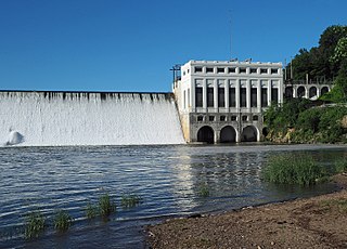
The Lake Zumbro Hydroelectric Generating Plant, also known as the City of Rochester Municipal Hydro-Electric Plant, is a hydroelectric facility on the Zumbro River in Mazeppa and Zumbro Townships in the U. S. State of Minnesota. The facility consists of a gravity dam and a powerhouse, and formerly included three houses for the plant operators. The houses were removed in the 1960s when the dam was retrofitted to allow remote operation of the generating equipment from Rochester. The impoundment created is called Lake Zumbro. This dam spans 904 feet (276 m) and is 66 feet (20 m) high, creating a reservoir with about 55 feet (17 m) of hydraulic head.
South Troy is an unincorporated community in Zumbro Township, Wabasha County, Minnesota, United States. It is located on U.S. Highway 63 about 13 miles north of Rochester. Nearby places include Hammond, Zumbro Falls, Mazeppa, Potsdam, and Oronoco. Wabasha County Roads 7 and 11 are nearby.

The United States Census Bureau defines the Rochester, Minnesota Metropolitan Statistical Area (MSA) as an area consisting of five counties in southeast Minnesota, anchored by the city of Rochester. As of 2018, the US Census Bureau estimates that the Rochester metropolitan statistical area has a population of 221,587. The Rochester–Austin combined statistical area has a population of 259,813 as of 2018.

This is a list of the National Register of Historic Places listings in Wabasha County, Minnesota. It is intended to be a complete list of the properties and districts on the National Register of Historic Places in Wabasha County, Minnesota, United States. The locations of National Register properties and districts for which the latitude and longitude coordinates are included below, may be seen in an online map.

Maple Springs is an unincorporated community in Pepin Township, Wabasha County, Minnesota, United States, along the Mississippi River and Lake Pepin. The Mississippi River and King Creek meet at Maple Springs.

Reads Landing is an unincorporated community in Pepin Township, Wabasha County, Minnesota, United States, along the Mississippi River. The community is located between Lake City and Wabasha along U.S. Highway 61 at the junction with Wabasha County Road 77 and near Wabasha, Lake City, Camp Lacupolis, and Maple Springs. Reads Landing is located within section 24 of Pepin Township.
Camp Lacupolis is an unincorporated community in Pepin Township, Wabasha County, Minnesota, United States, along the Mississippi River and Lake Pepin.
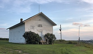
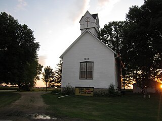
The Bear Valley Grange Hall is a historic meeting hall in Chester Township, Minnesota, United States. It was built in 1874 for the exclusive use of a local chapter of the National Grange of the Order of Patrons of Husbandry, an early farmers' advocacy group and fraternal organization. The chapter folded in the 1880s and the building has been used since as the Chester Town Hall. It was listed on the National Register of Historic Places in 1989 for having local significance in the theme of social history. It was nominated for being the only surviving Grange hall in Wabasha County—and one of only a few in Minnesota—and a rare example of a purpose-built Grange hall, as most chapters met in existing spaces like schools.
Theilman is an unincorporated community in Wabasha County, Minnesota, United States.
Jarrett is an unincorporated community in Wabasha County, Minnesota, United States.
Dumfries is an unincorporated community in Glasgow Township, Wabasha County, Minnesota, United States.
Bear Valley is an unincorporated community in Chester Township, Wabasha County, Minnesota, United States.


