Bellechester | |
---|---|
![]() Location of Bellechester, Minnesota | |
Coordinates: 44°22′15″N92°30′43″W / 44.37083°N 92.51194°W | |
Country | United States |
State | Minnesota |
Counties | Goodhue, Wabasha |
Area | |
• Total | 0.32 sq mi (0.82 km2) |
• Land | 0.32 sq mi (0.82 km2) |
• Water | 0.00 sq mi (0.00 km2) |
Elevation | 1,112 ft (339 m) |
Population (2020) | |
• Total | 176 |
• Density | 556.96/sq mi (214.80/km2) |
Time zone | UTC-6 (Central (CST)) |
• Summer (DST) | UTC-5 (CDT) |
FIPS code | 27-04798 [3] |
GNIS feature ID | 0639895 [2] |
Website | www |
Bellechester is a city in Goodhue and Wabasha counties in the U.S. state of Minnesota. The population was 175 at the 2010 census. [4] Most of Bellechester is in Goodhue County, with only a small part extending into Wabasha County.
Bellechester was laid out in 1877, and named for its location in Chester Township, belle being derived from French meaning "beautiful". [5] A post office was established on the Wabasha County side in 1879. [6]
Bellechester was a railway shipping point of pottery clay. [7]
According to the United States Census Bureau, the city has a total area of 0.31 square miles (0.80 km2), all land. [8]
County 2 Boulevard, County 16 Boulevard, and Wabasha County Road 7 are the main routes in the community.
Census | Pop. | Note | %± |
---|---|---|---|
1960 | 184 | — | |
1970 | 199 | 8.2% | |
1980 | 220 | 10.6% | |
1990 | 110 | −50.0% | |
2000 | 172 | 56.4% | |
2010 | 175 | 1.7% | |
2020 | 176 | 0.6% | |
U.S. Decennial Census [9] |
As of the census [10] of 2010, there were 175 people, 75 households, and 47 families living in the city. The population density was 564.5 inhabitants per square mile (218.0/km2). There were 79 housing units at an average density of 254.8 units per square mile (98.4 units/km2). The racial makeup of the city was 90.9% White, 8.6% from other races, and 0.6% from two or more races. Hispanic or Latino of any race were 10.3% of the population.
There were 75 households, of which 28.0% had children under the age of 18 living with them, 44.0% were married couples living together, 8.0% had a female householder with no husband present, 10.7% had a male householder with no wife present, and 37.3% were non-families. 30.7% of all households were made up of individuals, and 16% had someone living alone who was 65 years of age or older. The average household size was 2.33 and the average family size was 2.85.
The median age in the city was 37.5 years. 24% of residents were under the age of 18; 7.5% were between the ages of 18 and 24; 25.7% were from 25 to 44; 25.8% were from 45 to 64; and 17.1% were 65 years of age or older. The gender makeup of the city was 52.6% male and 47.4% female.
As of the census [3] of 2000, there were 172 people, 78 households, and 41 families living in the city. The population density was 543.6 inhabitants per square mile (209.9/km2). There were 78 housing units at an average density of 246.5 units per square mile (95.2 units/km2). The racial makeup of the city was 98.26% White, 1.16% Native American, and 0.58% from two or more races. Hispanic or Latino of any race were 1.74% of the population.
There were 78 households, out of which 26.9% had children under the age of 18 living with them, 39.7% were married couples living together, 10.3% had a female householder with no husband present, and 46.2% were non-families. 39.7% of all households were made up of individuals, and 14.1% had someone living alone who was 65 years of age or older. The average household size was 2.21 and the average family size was 2.98.
In the city, the population was spread out, with 24.4% under the age of 18, 10.5% from 18 to 24, 26.7% from 25 to 44, 21.5% from 45 to 64, and 16.9% who were 65 years of age or older. The median age was 37 years. For every 100 females, there were 91.1 males. For every 100 females age 18 and over, there were 94.0 males.
The median income for a household in the city was $33,333, and the median income for a family was $41,250. Males had a median income of $24,375 versus $24,107 for females. The per capita income for the city was $19,927. None of the families and 5.2% of the population were living below the poverty line, including no under eighteens and 5.7% of those over 64.
Wabasha County is a county in the U.S. state of Minnesota. As of the 2020 census, the population was 21,387. Its county seat is Wabasha.
Rowley is a city in Buchanan County, Iowa, United States. The population was 270 at the time of the 2020 census.
Elgin is a city in Wabasha County, Minnesota, United States on Minnesota State Highway 42. The population was 1,089 at the 2010 census. Its annual festival is Elgin Cheese Days.
Elgin Township is a township in Wabasha County, Minnesota, United States. The population was 787 at the 2000 census.
Gillford Township is a township in Wabasha County, Minnesota, United States. The population was 507 at the 2020 census. The unincorporated community of Oak Center is located in the township.
Greenfield Township is a township in Wabasha County, Minnesota, United States. The population was 1,254 at the 2000 census.
Hammond is a city in Wabasha County, Minnesota, United States. The population was 132 at the 2010 census.
Highland Township is a township in Wabasha County, Minnesota, United States. The population was 471 at the 2000 census.
Hyde Park Township is a township in Wabasha County, Minnesota, United States. The population was 275 at the 2000 census.
Kellogg is a city in Wabasha County, Minnesota, along the Zumbro River. The population was 456 at the 2010 census.
Lake Township is a township in Wabasha County, Minnesota, United States. The population was 412 at the 2000 census.
Millville is a city along the Zumbro River in Wabasha County, Minnesota, United States. The population was 182 at the 2010 census.
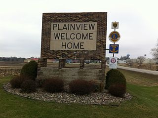
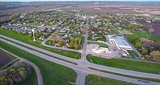
Plainview is a city in Wabasha County, Minnesota, United States. The population was 3,483 at the 2020 census, up from 3,340 at the 2010 census. The author Jon Hassler was raised in Plainview and some of the places in his writing are based on the town.
Wabasha is a city and the county seat of Wabasha County, Minnesota, United States. The population was 2,559 at the time of the 2020 census. It is on the Mississippi River, near its confluence with the Zumbro River.
West Albany Township is a township in Wabasha County, Minnesota, United States. The population was 439 at the 2000 census.
Zumbro Township is a township in Wabasha County, Minnesota, United States. The population was 715 at the 2000 census. The unincorporated community of South Troy is in Zumbro Township.
Lake City is a city in Goodhue and Wabasha counties in the U.S. state of Minnesota. It lies along Lake Pepin, a wide portion of the Mississippi River. The population was 5,252 at the 2020 census. Most of Lake City is located within Wabasha County with only a small portion in Goodhue County. Lake City is part of the Rochester, Minnesota Metropolitan Statistical Area.
Minneiska is a city in Wabasha and Winona counties in the U.S. state of Minnesota. The population was 97 at the 2020 census.
Nelson is a village in Buffalo County in the U.S. state of Wisconsin. The population was 374 at the 2010 census. The village is surrounded by the Town of Nelson.
Nelson is a town in Buffalo County in the U.S. state of Wisconsin. The population was 571 at the 2010 census. The village of Nelson is located within the town. The unincorporated community of Misha Mokwa and railroad junction Trevino are located in the town. The unincorporated community of Urne is located partially in the town.
44°22′06″N92°30′41″W / 44.36833°N 92.51139°W