
Rice County is a county located in the south central portion of the U.S. state of Minnesota. As of the 2020 census, the population was 67,097. Its county seat is Faribault.

Goodhue County is a county in the U.S. state of Minnesota. As of the 2020 census, the population was 47,582. Its county seat is Red Wing. Nearly all of Prairie Island Indian Community is within the county.

Cannon Falls is a city in Goodhue County, Minnesota, United States. The population was 4,083 at the 2010 census. Located along U.S. Route 52, southeast of the Twin Cities, Cannon Falls is the home of Pachyderm Studio, where many famous musicians have recorded, including Nirvana, which recorded its 1993 album In Utero there.
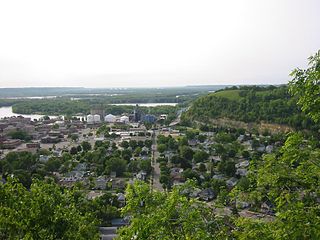
Red Wing is a city in Goodhue County, Minnesota, United States, along the upper Mississippi River. The population was 16,547 at the 2020 census. It is the county seat of Goodhue County.
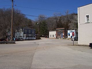
Welch is an unincorporated community in Welch Township, Goodhue County, Minnesota, United States.

The Cannon River a tributary of the Mississippi River flows 112 miles (180 km) from Shields Lake near Shieldsville to Red Wing in the U.S. state of Minnesota, where it joins the Mississippi River. It drains a watershed approximately 1460 square miles (3,780 km²) in size. The river flows through the counties of Le Sueur, Rice, Dakota, and Goodhue.
Stanton is an unincorporated community in Stanton Township, Goodhue County, Minnesota, United States.
Vasa is an unincorporated community in Vasa Township, Goodhue County, Minnesota, United States.

The Cannon Valley Trail is a paved rail trail that follows the Cannon River in southeast Minnesota. The trail follows an abandoned Chicago Great Western Railway corridor for 20 miles (32 km) between Cannon Falls, Minnesota and Red Wing, Minnesota. In the spring, summer, and fall months, the trail is open to hiking, biking, and inline skating. In the winter months, the trail is groomed for cross-country skiing.
Hader is an unincorporated community in Goodhue County, Minnesota, United States.
The Goodhue Pioneer State Trail is a multi-use recreational rail trail in southeastern Minnesota, USA. The 10 miles (16 km) of trail currently exist in two segments, separated by a six-mile (10 km) gap. The four-mile (6 km) northern segment is a paved trail running from Red Wing, Minnesota, to the Hay Creek section of the Richard J. Dorer Memorial Hardwood State Forest near Hay Creek Township. The 5.5-mile (8.9 km) southern section is a natural-surface trail running northward from the Zumbrota Covered Bridge Park in Zumbrota, Minnesota. The trail corridor follows an abandoned Chicago Great Western Railway segment that was originally built by the Duluth, Red Wing, & Southern Railroad in 1888, and abandoned in 1964 following a derailment.
Ryan is an unincorporated community in Belle Creek Township, Goodhue County, Minnesota, United States.
Belvidere Mills is an unincorporated community in Belvidere Township, Goodhue County, Minnesota, United States.
Wastedo is an unincorporated community in Leon Township, Goodhue County, Minnesota, United States.
Sogn is an unincorporated community in Warsaw Township, Goodhue County, Minnesota, United States.
Hay Creek is an unincorporated community in Hay Creek Township, Goodhue County, Minnesota, United States.
Wacouta is an unincorporated community in Wacouta Township, Goodhue County, Minnesota, United States.
Claybank is an unincorporated community in Goodhue Township, Goodhue County, Minnesota, United States.
Belle Creek is an unincorporated community in Belle Creek Township, Goodhue County, Minnesota, United States.

The Mill Towns State Trail is a multi-use trail in development along the Cannon River in Minnesota, United States. Currently a 3-mile-long (4.8 km) rail trail linking Northfield and Dundas, the trail is planned to extend southward to Faribault and eastward to Cannon Falls.


