Wanamingo, Minnesota

Last updated

Wanamingo
City
Motto: 
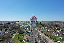
"Poised For Tomorrow" Wanamingo Water Tower 4-30-2020.jpg
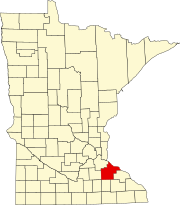
Goodhue County Minnesota Incorporated and Unincorporated areas Wanamingo Highlighted.svg
Location of Wanamingo, Minnesota
Coordinates: 44°18′9″N92°47′29″W / 44.30250°N 92.79139°W / 44.30250; -92.79139
CountryUnited States
State Minnesota
County Goodhue
Government
  MayorRyan Holmes
  City AdministratorMichael Boulton
Area
[1]
  Total1.42 sq mi (3.67 km2)
  Land1.42 sq mi (3.67 km2)
  Water0.00 sq mi (0.00 km2)
Elevation
[2]
1,056 ft (322 m)
Population
 (2020)
  Total1,113
  Density785.46/sq mi (303.21/km2)
Time zone UTC-6 (Central (CST))
  Summer (DST) UTC-5 (CDT)
ZIP code
55983
Area code 507
FIPS code 27-67972 [3]
GNIS feature ID0653758 [2]
Website cityofwanamingo.com

Wanamingo is a community in Goodhue County, Minnesota, United States, incorporated as a city. It lies along the North Fork of the Zumbro River. The population was 1,086 at the 2010 census. [4]

Contents

The ethanol company POET LLC started on the farm of Lowell Broin in 1983 near the community.

Geography

According to the United States Census Bureau, the city has a total area of 1.40 square miles (3.63 km2), all land. [5]

Minnesota State Highways 57 and 60 are two of the main routes in the city.

U.S. Route 52 passes nearby.

Demographics

Historical population
CensusPop.Note
1920 350
1930 47134.6%
1940 449−4.7%
1950 49610.5%
1960 5408.9%
1970 5746.3%
1980 71724.9%
1990 84718.1%
2000 1,00718.9%
2010 1,0867.8%
2020 1,1132.5%
U.S. Decennial Census [6]

2010 census

As of the census [7] of 2010, there were 1,086 people, 461 households, and 294 families living in the city. The population density was 775.7 inhabitants per square mile (299.5/km2). There were 503 housing units at an average density of 359.3 per square mile (138.7/km2). The racial makeup of the city was 97.6% White, 1.7% African American, 0.1% Asian, 0.3% from other races, and 0.4% from two or more races. Hispanic or Latino of any race were 1.1% of the population.

There were 461 households, of which 29.3% had children under the age of 18 living with them, 50.5% were married couples living together, 8.7% had a female householder with no husband present, 4.6% had a male householder with no wife present, and 36.2% were non-families. 31.0% of all households were made up of individuals, and 13.9% had someone living alone who was 65 years of age or older. The average household size was 2.31 and the average family size was 2.87.

The median age in the city was 38.4 years. 23.2% of residents were under the age of 18; 7.9% were between the ages of 18 and 24; 27.6% were from 25 to 44; 22% were from 45 to 64; and 19.2% were 65 years of age or older. The gender makeup of the city was 49.7% male and 50.3% female.

2000 census

As of the census [3] of 2000, there were 1,007 people, 404 households, and 273 families living in the city. The population density was 919.4 inhabitants per square mile (355.0/km2). There were 411 housing units at an average density of 375.2 per square mile (144.9/km2). The racial makeup of the city was 98.71% White, 0.40% Asian, and 0.89% from two or more races. Hispanic or Latino of any race were 0.20% of the population.

There were 404 households, out of which 32.4% had children under the age of 18 living with them, 58.4% were married couples living together, 5.7% had a female householder with no husband present, and 32.4% were non-families. 28.0% of all households were made up of individuals, and 15.6% had someone living alone who was 65 years of age or older. The average household size was 2.45 and the average family size was 3.04.

In the city, the population was spread out, with 26.8% under the age of 18, 6.9% from 18 to 24, 27.3% from 25 to 44, 20.1% from 45 to 64, and 19.0% who were 65 years of age or older. The median age was 37 years. For every 100 females, there were 100.6 males. For every 100 females age 18 and over, there were 99.2 males.

The median income for a household in the city was $40,000, and the median income for a family was $46,125. Males had a median income of $30,583 versus $23,295 for females. The per capita income for the city was $18,466. About 5.8% of families and 8.8% of the population were below the poverty line, including 4.7% of those under age 18 and 12.2% of those age 65 and over.

Related Research Articles

<span class="mw-page-title-main">Pelham, Alabama</span> City in Alabama, United States

Pelham is a city in Shelby County, Alabama, United States. The population was 24,318 at the 2020 census, It incorporated on July 10, 1964 and is a suburb located in the Birmingham metropolitan area, Alabama which was home to nearly 1.2 million residents as of the 2020 census. It was named for Confederate Civil War officer John Pelham.

<span class="mw-page-title-main">Mango, Florida</span> Census-designated place in Florida, United States

Mango is a census-designated place (CDP) in Hillsborough County, Florida, United States. The population was 12,699 at 2020 census, up from the 11,313 at the 2010 census.

<span class="mw-page-title-main">Coral Terrace, Florida</span> Census-designated place in Florida

Coral Terrace is a suburban unincorporated community and census-designated place (CDP) in Miami-Dade County, Florida, United States. It is part of the Miami metropolitan area of South Florida. The population was 23,142 at the 2020 census, down from 24,376 in 2010.

<span class="mw-page-title-main">Warren, Indiana</span> Town in Indiana, United States

Warren is a town in Salamonie Township, Huntington County, Indiana. The population of Warren was 1,182 at the time of the 2020 census.

<span class="mw-page-title-main">Mondamin, Iowa</span> City in Iowa, United States

Mondamin is a city in Harrison County, Iowa, United States. The population was 339 at the time of the 2020 census.

<span class="mw-page-title-main">Craig, Iowa</span> City in Iowa, United States

Craig is a city in Plymouth County, Iowa, United States. The population was 79 at the 2020 census.

<span class="mw-page-title-main">Conway Springs, Kansas</span> City in Sumner County, Kansas

Conway Springs is a city in Sumner County, Kansas, United States. As of the 2020 census, the population of the city was 1,086.

<span class="mw-page-title-main">French Settlement, Louisiana</span> Village in Louisiana, United States

French Settlement is a village in Livingston Parish, Louisiana, United States. The population was 1,073 in 2020. It is part of the Baton Rouge metropolitan statistical area.

<span class="mw-page-title-main">Wanamingo Township, Goodhue County, Minnesota</span> Township in Minnesota, United States

Wanamingo Township is a township in Goodhue County, Minnesota, United States. The population was 504 at the 2000 census.

<span class="mw-page-title-main">Deer Creek, Minnesota</span> City in Minnesota, United States

Deer Creek is a city in Otter Tail County, Minnesota, United States. The population was 330 at the 2020 census.

<span class="mw-page-title-main">Yah-ta-hey, New Mexico</span> CDP in New Mexico, United States

Yah-ta-hey is a census-designated place (CDP) in McKinley County, New Mexico, United States. As of the 2000 census, the CDP population was 580. The English name for this place is an approximation of a Navajo greeting, though the actual Navajo name means "like a devil", in reference to J.B. Tanner, who operated the trading post located here; the same name is used for Aneth, Utah, where Tanner also worked.

<span class="mw-page-title-main">Warwick, North Dakota</span> City in North Dakota, United States

Warwick is a city in Benson County, North Dakota, United States. The population was 55 at the 2020 census. Warwick was founded in 1907.

<span class="mw-page-title-main">Hebron, Ohio</span> Village in Ohio, USA

Hebron is a village in Licking County, Ohio, United States. The population was 2,326 at the 2020 census.

<span class="mw-page-title-main">Salem, South Dakota</span> City in South Dakota, United States

Salem is a city in and the county seat of McCook County, South Dakota, United States. The population was 1,325 at the 2020 census. The current mayor is Shawn English.

<span class="mw-page-title-main">Crooks, South Dakota</span> City in South Dakota, United States

Crooks is a city in Minnehaha County, South Dakota, United States and is a suburb of Sioux Falls. The population was 1,362 at the 2020 census. Crooks was named New Hope until 1904. The town's present name honors W. A. Crooks, a local politician.

<span class="mw-page-title-main">Scottsburg, Virginia</span> Town in Virginia, United States

Scottsburg is a town in Halifax County, Virginia, United States. The population was 119 at the 2010 census, down from 145 at the 2000 census.

<span class="mw-page-title-main">Waitsburg, Washington</span> City in Washington, United States

Waitsburg is a city in Walla Walla County, Washington, United States. The population was 1,166 at the 2020 census. Waitsburg has a unique city classification in Washington state, being the state's only city which still operates under its territorial charter.

<span class="mw-page-title-main">Exeter, Wisconsin</span> Town in Wisconsin, United States

Exeter is a town in Green County, Wisconsin, United States. The population was 1,261 at the 2000 census. The unincorporated communities of Dayton and Ross Crossing are located in the town.

<span class="mw-page-title-main">Casnovia, Michigan</span> Village in Michigan, United States

Casnovia is a village in the U.S. state of Michigan. It is situated on the boundary between Muskegon and Kent counties and lies partially within each. The population was 316 at the 2020 census.

<span class="mw-page-title-main">Minnesota Lake, Minnesota</span> City in Minnesota, United States

Minnesota Lake is a city in Blue Earth and Faribault counties in the State of Minnesota. The population was 661 at the 2020 census. The bulk of the city is in Faribault County; a small part extends into Blue Earth County.

References

  1. "2020 U.S. Gazetteer Files". United States Census Bureau. Retrieved July 24, 2022.
  2. 1 2 U.S. Geological Survey Geographic Names Information System: Wanamingo, Minnesota
  3. 1 2 "U.S. Census website". United States Census Bureau . Retrieved January 31, 2008.
  4. "2010 Census Redistricting Data (Public Law 94-171) Summary File". American FactFinder. United States Census Bureau . Retrieved April 27, 2011.[ dead link ]
  5. "US Gazetteer files 2010". United States Census Bureau . Retrieved November 13, 2012.
  6. "Census of Population and Housing". Census.gov. Retrieved June 4, 2015.
  7. "U.S. Census website". United States Census Bureau . Retrieved November 13, 2012.

44°18′16″N92°47′26″W / 44.30444°N 92.79056°W / 44.30444; -92.79056