
Rice County is a county located in the south central portion of the U.S. state of Minnesota. As of the 2020 census, the population was 67,097. Its county seat is Faribault.

Goodhue County is a county in the U.S. state of Minnesota. As of the 2020 census, the population was 47,582. Its county seat is Red Wing. Nearly all of Prairie Island Indian Community is within the county.

Cannon Falls is a city in Goodhue County, Minnesota, United States. The population was 4,083 at the 2010 census. Located along U.S. Route 52, southeast of the Twin Cities, Cannon Falls is the home of Pachyderm Studio, where many famous musicians have recorded, including Nirvana, which recorded its 1993 album In Utero there.

Wanamingo is a community in Goodhue County, Minnesota, United States, incorporated as a city. It lies along the North Fork of the Zumbro River. The population was 1,086 at the 2010 census.
Wanamingo Township is a township in Goodhue County, Minnesota, United States. The population was 504 at the 2000 census.
Zumbrota Township is a township in Goodhue County, Minnesota, United States. The population was 591 at the 2000 census.
Welch is an unincorporated community in Welch Township, Goodhue County, Minnesota, United States.
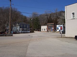
Stanton is an unincorporated community in Stanton Township, Goodhue County, Minnesota, United States.
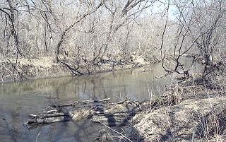
The Zumbro River is a tributary of the Mississippi River in the Driftless Area of southeastern Minnesota in the United States. It is 64.6 miles (104.0 km) long from the confluence of its principal tributaries and drains a watershed of 1,428 square miles (3,700 km2). The river's name in English is a change from its French name Rivière des Embarras due to its mouth near Pine Island in the Mississippi River; the pronunciation changed from [dez‿ɑ̃.ba.ʁɑ] to. The Dakota name for this river is Wapka Wazi Oju, having reference to the grove of great white pines at Pine Island.
The Goodhue Pioneer State Trail is a multi-use recreational rail trail in southeastern Minnesota, USA. The 10 miles (16 km) of trail currently exist in two segments, separated by a six-mile (10 km) gap. The four-mile (6 km) northern segment is a paved trail running from Red Wing, Minnesota, to the Hay Creek section of the Richard J. Dorer Memorial Hardwood State Forest near Hay Creek Township. The 5.5-mile (8.9 km) southern section is a natural-surface trail running northward from the Zumbrota Covered Bridge Park in Zumbrota, Minnesota. The trail corridor follows an abandoned Chicago Great Western Railway segment that was originally built by the Duluth, Red Wing, & Southern Railroad in 1888, and abandoned in 1964 following a derailment.
Ryan is an unincorporated community in Belle Creek Township, Goodhue County, Minnesota, United States.
Belvidere Mills is an unincorporated community in Belvidere Township, Goodhue County, Minnesota, United States.
Berne is an unincorporated community in Milton Township, Dodge County, Minnesota, United States. The community is located near the junction of State Highway 57 and Dodge County Road 24. The Middle Fork of the Zumbro River flows nearby.
White Rock is an unincorporated community in Goodhue County, Minnesota, United States.
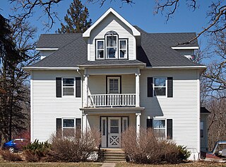
Holden Lutheran Church Parsonage is a historic church parsonage at Kenyon in Wanamingo Township, Goodhue County, Minnesota. The building is located on the north side of Goodhue County Highway 8. The building was added to the National Register in 1980.
Wastedo is an unincorporated community in Leon Township, Goodhue County, Minnesota, United States.
Sogn is an unincorporated community in Warsaw Township, Goodhue County, Minnesota, United States.
Forest Mills is an unincorporated community in Zumbrota Township, Goodhue County, Minnesota, United States.
Roscoe is an unincorporated community in Roscoe Township, Goodhue County, Minnesota, United States.
Belle Creek is an unincorporated community in Belle Creek Township, Goodhue County, Minnesota, United States.


