Vasa Township, Goodhue County, Minnesota

Last updated

Vasa Township, Minnesota
USA Minnesota location map.svg
Red pog.svg
Vasa Township, Minnesota
Location within the state of Minnesota
Usa edcp location map.svg
Red pog.svg
Vasa Township, Minnesota
Vasa Township, Minnesota (the United States)
Coordinates: 44°30′21″N92°44′3″W / 44.50583°N 92.73417°W / 44.50583; -92.73417
Country United States
State Minnesota
County Goodhue
Area
  Total41.2 sq mi (106.6 km2)
  Land41.0 sq mi (106.1 km2)
  Water0.2 sq mi (0.5 km2)
Elevation
1,093 ft (333 m)
Population
 (2000)
  Total872
  Density21.3/sq mi (8.2/km2)
Time zone UTC-6 (Central (CST))
  Summer (DST) UTC-5 (CDT)
ZIP code
55089
Area code 651
FIPS code 27-66640 [1]
GNIS feature ID0665852 [2]

Vasa Township is a township in Goodhue County, Minnesota, United States. The population was 872 at the 2000 census. Part of the township is part of the Vasa Historic District on the National Register of Historic Places.

Contents

Vasa Township was organized in 1858 and named for Gustav I of Sweden (Gustav Vasa). [3] The township has been referred to by multiple names in the past, including Mattson('s) Settlement, Vasa, and Vasa Village.

History

In 1853 Hans Mattson was the first European to settle the area. He later encouraged many Swedish families to join him. The group of families was known as the Mattson Settlement. The settlement was later renamed Vasa (variously referred to as Vasa Village), for the local Swedish church who had chosen the name of the king of Sweden during the Reformation. [4]

The United States government and the Upper Dakota Sioux entered into the Treaty of Traverse des Sioux in 1851, which made a large swathe of what is today western and southern Minnesota US land, including the growing site of Vasa. While there had already been rapid growth in European settlement of the area largely against Dakota wishes, as US leaders pushed the Westward Expansion, the 1851 treaty further encouraged the wave. Between 1854 and 1880, Vasa grew beyond the original 10 families and the greater Goodhue County recorded more than 4,300 residents. During the 1800s, 19 buildings were built in the village center. [5]

Vasa prospered agriculturally and was notable for hosting a US post office on the original Minnesota Rural Free Delivery route until the 1950s when core businesses closed and growth became stagnant. Today the site of the original village, including the church and orphanage, is on the National Register of Historical Places as the Vasa Historical District. It is the best preserved early Swedish settlement in Minnesota with architecture representative of the era, from which Swedish-descent Americans in Minnesota continue to draw cultural imagery. [6]

Historic district

Vasa Historic District
Vasa Museum & Caretaker's House.jpg
Vasa Museum and Caretaker's House
Nearest city Red Wing, Minnesota
Area100 acres (40 ha)
MPS Rural Goodhue County MRA (AD)
NRHP reference No. 75000983 [7]
Added to NRHPMay 30, 1975

A portion of the community is listed on the National Register of Historic Places as the Vasa Historic District. Vasa was established in 1853 by Swedish immigrant farmers. While its population declined significantly in the twentieth century, the architecture and landscape of the district is well-preserved and its National Register nomination described it as "the most intact... of the original Swedish colonies in Minnesota". The Old Vasa Swedish Lutheran Church, which was built in 1861, is now a museum of local Swedish history. [8] Vasa Children's Home was originally located in the church and later had its own building nearby.

Geography

According to the United States Census Bureau, the township has a total area of 41.2 square miles (106.6 km2), of which 41.0 square miles (106.1 km2) is land and 0.2 square mile (0.5 km2) (0.49%) is water.

State Highway 19 (MN 19) and County 7 Boulevard are two of the main routes in the township.

Demographics

As of the census [1] of 2000, there were 872 people, 293 households, and 239 families residing in the township. The population density was 21.3 people per square mile (8.2/km2). There were 310 housing units at an average density of 7.6/sq mi (2.9/km2). The racial makeup of the township was 99.08% White, 0.11% African American, 0.23% Native American, 0.11% from other races, and 0.46% from two or more races. Hispanic or Latino of any race were 0.80% of the population.

There were 293 households, out of which 42.0% had children under the age of 18 living with them, 68.9% were married couples living together, 5.8% had a female householder with no husband present, and 18.1% were non-families. 13.0% of all households were made up of individuals, and 6.1% had someone living alone who was 65 years of age or older. The average household size was 2.98 and the average family size was 3.29.

In the township the population was spread out, with 30.3% under the age of 18, 6.5% from 18 to 24, 27.2% from 25 to 44, 25.1% from 45 to 64, and 10.9% who were 65 years of age or older. The median age was 38 years. For every 100 females, there were 106.6 males. For every 100 females age 18 and over, there were 106.1 males.

The median income for a household in the township was $53,281, and the median income for a family was $56,688. Males had a median income of $33,750 versus $22,500 for females. The per capita income for the township was $23,629. About 3.0% of families and 4.9% of the population were below the poverty line, including 4.6% of those under age 18 and 8.1% of those age 65 or over.

Notable figures

See also

Related Research Articles

<span class="mw-page-title-main">Goodhue County, Minnesota</span> County in Minnesota, United States

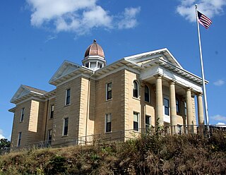
Goodhue County is a county in the U.S. state of Minnesota. As of the 2020 census, the population was 47,582. Its county seat is Red Wing. Nearly all of Prairie Island Indian Community is within the county.

<span class="mw-page-title-main">Dodge County, Minnesota</span> County in Minnesota, United States

Dodge County is a county in the U.S. state of Minnesota. The population was 20,867 as of the 2020 census. Its county seat is Mantorville.

Nordland Township is a township in Aitkin County, Minnesota, United States. The population was 972 as of the 2010 census.

Mayhew Lake Township is a township in Benton County, Minnesota, United States. The population was 831 as of the 2010 census. Mayhew Lake Township was named for George V. Mayhew, an early settler of Benton County who became a state legislator.

Rapidan Township is a township in Blue Earth County, Minnesota, United States. The population was 1,101 as of the 2010 census.

Cannon Falls Township is a township in Goodhue County, Minnesota, United States. The population was 1,236 at the 2000 census.

Featherstone Township is a township in Goodhue County, Minnesota, United States. The population was 785 at the 2000 census.

Goodhue Township is a township in Goodhue County, Minnesota, United States. The population was 530 at the 2000 census.

Hay Creek Township is a township in Goodhue County, Minnesota, United States. The population was 862 at the 2000 census. The unincorporated community of Hay Creek is located within the township.

<span class="mw-page-title-main">Zumbrota, Minnesota</span> City in Minnesota, United States

Zumbrota is a city in Goodhue County, Minnesota, United States, along the North Fork of the Zumbro River. The population was 3,252 at the 2010 census. It promotes itself as "the only Zumbrota in the world."

Anthony Township is a township in Norman County, Minnesota. As of the 2000 census, the population was 85.

Thomastown Township is a township in Wadena County, Minnesota, United States. The population was 714 at the 2000 census.

Otisco Township is a township in Waseca County, Minnesota, United States. The population was 629 at the 2000 census.

<span class="mw-page-title-main">Scandia, Minnesota</span> City in Minnesota, United States

Scandia is a city in Washington County, Minnesota, United States. The population was 3,984 at the 2020 census. Scandia is 25 miles northeast of Saint Paul, Minnesota.

Brandrup Township is a township in Wilkin County, Minnesota, United States. The population was 172 at the 2000 census.

Homer Township is a township in Winona County, Minnesota, United States. The population was 1,356 at the 2010 census.

Franklin Township is a rural township in Wright County, Minnesota, United States. The township population was 2,774 at the 2000 census.

Marysville Township is a township in Wright County, Minnesota, United States. The population was 2,097 at the 2000 census.

<span class="mw-page-title-main">Bethel Township, Armstrong County, Pennsylvania</span> Township in Pennsylvania, United States

Bethel Township is a township in Armstrong County, Pennsylvania, United States. The population was 1,096 at the 2020 census, a decrease from the figure of 1,183 tabulated in 2010.

<span class="mw-page-title-main">Amity Township, Berks County, Pennsylvania</span> Township in Pennsylvania, United States

Amity Township is a township in Berks County, Pennsylvania, United States. The population was 13,435 at the 2020 census. Amity Township, especially in the Douglassville area, is seeing growth in development.

References

  1. 1 2 "U.S. Census website". United States Census Bureau . Retrieved January 31, 2008.
  2. "US Board on Geographic Names". United States Geological Survey. October 25, 2007. Retrieved January 31, 2008.
  3. Upham, Warren (1920). Minnesota Geographic Names: Their Origin and Historic Significance. Minnesota Historical Society. p.  209.
  4. "Our History, Vasa Lutheran Church" . Retrieved July 2, 2023.
  5. "History of Vasa MN". Archived from the original on October 27, 2013. Retrieved February 23, 2023.
  6. "National Register Information System". National Register of Historic Places . National Park Service. November 2, 2013.
  7. Lutz, Thomas (March 28, 1975). "National Register of Historic Places Inventory - Nomination Form: Vasa Historic District". National Archives Catalog. National Archives and Records Administration . Retrieved February 24, 2023.