
Goodhue County is a county in the U.S. state of Minnesota. As of the 2020 census, the population was 47,582. Its county seat is Red Wing. Nearly all of Prairie Island Indian Community is within the county.
Hay Creek Township is a township in Goodhue County, Minnesota, United States. The population was 862 at the 2000 census. The unincorporated community of Hay Creek is located within the township.
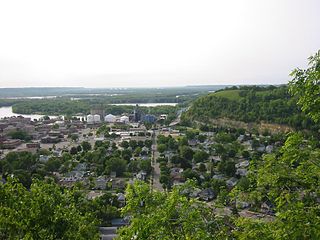
Red Wing is a city in Goodhue County, Minnesota, United States, along the upper Mississippi River. The population was 16,547 at the 2020 census. It is the county seat of Goodhue County.
Welch is an unincorporated community in Welch Township, Goodhue County, Minnesota, United States.

The Cannon Valley Trail is a paved rail trail that follows the Cannon River in southeast Minnesota. The trail follows an abandoned Chicago Great Western Railway corridor for 20 miles (32 km) between Cannon Falls, Minnesota and Red Wing, Minnesota. In the spring, summer, and fall months, the trail is open to hiking, biking, and inline skating. In the winter months, the trail is groomed for cross-country skiing.

Sakatah Singing Hills State Trail is a 41-mile-long (66 km) paved multi-use rail trail connecting Faribault and Mankato, Minnesota. It is maintained by the Minnesota Department of Natural Resources, which converted it from a railroad line. The name derives from the Dakota people who lived in the region; "Sakatah" translates into "singing hills". It began as a snowmobile trail and is now shared by hikers, joggers and cross-country skiers. There are sections of parallel dirt trail for horseback riders but they are not continuous. The landscape is mostly cultivated land with remnant stands of prairie and Big Woods. The trail passes through Sakatah Lake State Park and runs through city streets in Waterville.

Minnesota State Highway 58 (MN 58) is a 23.538-mile-long (37.881 km) highway in southeast Minnesota, which runs from its interchange with U.S. 52 / State Highway 60 (co-signed) in Zumbrota and continues north to its northern terminus at its intersection with U.S. Highway 61 in Red Wing.

Hay Creek is a small trout stream in southeastern Minnesota. It has its headwaters west of Goodhue and empties into the Mississippi River just to the north of Red Wing. It runs 25.1 miles (40.4 km). Hay Creek was named for the hay meadows near its banks. A railroad once ran along Hay Creek from the claybanks near Goodhue to the pottery and stoneware factories in Red Wing, which also made use of the water from the creek. The railroad was torn up in 1937, but traces such as trestle pilings remain.
The Goodhue Pioneer State Trail is a multi-use recreational rail trail in southeastern Minnesota, USA. The 10 miles (16 km) of trail currently exist in two segments, separated by a six-mile (10 km) gap. The four-mile (6 km) northern segment is a paved trail running from Red Wing, Minnesota, to the Hay Creek section of the Richard J. Dorer Memorial Hardwood State Forest near Hay Creek Township. The 5.5-mile (8.9 km) southern section is a natural-surface trail running northward from the Zumbrota Covered Bridge Park in Zumbrota, Minnesota. The trail corridor follows an abandoned Chicago Great Western Railway segment that was originally built by the Duluth, Red Wing, & Southern Railroad in 1888, and abandoned in 1964 following a derailment.
Eggleston is a neighborhood of the city of Red Wing in Goodhue County, Minnesota, United States.
Ryan is an unincorporated community in Belle Creek Township, Goodhue County, Minnesota, United States.
Belvidere Mills is an unincorporated community in Belvidere Township, Goodhue County, Minnesota, United States.
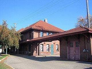
The Chicago Great Western Depot at 726 East Main Street in Red Wing, in the U.S. State of Minnesota, is a former railroad station listed on the National Register of Historic Places. The depot was built in 1906 after the Chicago Great Western Railway (CGW) acquired two small railroads: the Minnesota Central, which connected to Cannon Falls; and the Duluth, Red Wing, and Southern, which connected to Zumbrota. CGW established a divisional headquarters and built this depot in 1906, with passenger space on the first floor and office space on the second floor. The red brick structure was the largest depot the railroad built in Minnesota.
White Rock is an unincorporated community in Goodhue County, Minnesota, United States.

Immanuel Lutheran Church is a historic church in Hay Creek Township, Goodhue County, Minnesota, Goodhue County, Minnesota, United States, near the city of Red Wing. The congregation was organized in 1858 by German Lutheran families who had settled in Flower Valley. Their first pastor, William Wier, came to administer the sacrament twice a year through the summer of 1861. The first church building was a three-room building completed around 1862. A number of German Lutherans in the southern part of the township wanted to join the Immanuel congregation, so the congregation established a northern district and a southern district. This arrangement continued for a while until the building in Flower Valley was moved to the current location in Hay Creek in 1868. The land in Hay Creek consisted of two acres donated by a Mr. W. Plote.
Wacouta is an unincorporated community in Wacouta Township, Goodhue County, Minnesota, United States.
Claybank is an unincorporated community in Goodhue Township, Goodhue County, Minnesota, United States.
Belle Creek is an unincorporated community in Belle Creek Township, Goodhue County, Minnesota, United States.

The Mill Towns State Trail is a multi-use trail in development along the Cannon River in Minnesota, United States. Currently a 3-mile-long (4.8 km) rail trail linking Northfield and Dundas, the trail is planned to extend southward to Faribault and eastward to Cannon Falls.


