The Chequamegon–Nicolet National Forest is a 1,530,647-acre (6,194.31 km2) U.S. National Forest in northern Wisconsin in the United States. Due to logging in the early part of the 20th century, very little old growth forest remains. Some of the trees there were planted by the Civilian Conservation Corps in the 1930s. The national forest land trees and vegetation are part of the North Woods Ecoregion that prevails throughout the upper Great Lakes region.

The Piney Woods is a temperate coniferous forest terrestrial ecoregion in the Southern United States covering 54,400 square miles (141,000 km2) of East Texas, southern Arkansas, western Louisiana, and southeastern Oklahoma. These coniferous forests are dominated by several species of pine as well as hardwoods including hickory and oak. Historically the most dense part of this forest region was the Big Thicket though the lumber industry dramatically reduced the forest concentration in this area and throughout the Piney Woods during the 19th and 20th centuries. The World Wide Fund for Nature considers the Piney Woods to be one of the critically endangered ecoregions of the United States. The United States Environmental Protection Agency (EPA) defines most of this ecoregion as the South Central Plains.

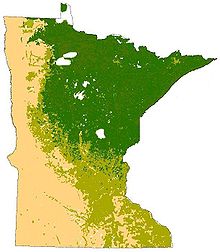
The Laurentian Mixed Forest Province, also known as the North Woods, is a forested ecoregion in eastern North America. Among others, this terminology has been adopted by the Minnesota Department of Natural Resources. Similar, though not necessarily entirely identical regions, are identified by the United States Environmental Protection Agency as Northern Lakes and Forests, and by the World Wildlife Fund by regions such as the Western Great Lakes forests and Eastern forest-boreal transition.

Aspen parkland refers to a very large area of transitional biome between prairie and boreal forest in two sections, namely the Peace River Country of northwestern Alberta crossing the border into British Columbia, and a much larger area stretching from central Alberta, all across central Saskatchewan to south central Manitoba and continuing into small parts of the US states of Minnesota and North Dakota. Aspen parkland consists of groves of aspen, poplar and spruce, interspersed with areas of prairie grasslands, also intersected by large stream and river valleys lined with aspen-spruce forests and dense shrubbery. This is the largest boreal-grassland transition zone in the world and is a zone of constant competition and tension as prairie and woodlands struggle to overtake each other within the parkland.

Glacial Lakes State Park is a state park of Minnesota, USA, approximately 5 miles (8.0 km) south of Starbuck. It was founded in 1963 to preserve some of the remaining rolling prairie which previously covered much of the state. Located in the Leaf Mountains, the park and the area around it contains many glacial landforms created by the Wisconsonian glaciation.

The North American cougar is a cougar subspecies in North America. It is the biggest cat in North America. And the second largest cat in the New World. It was once common in eastern North America and is still prevalent in the western half of the continent. This subspecies includes populations in western Canada, the western United States, Florida, Mexico and Central America, and possibly South America northwest of the Andes Mountains. It thus includes the extirpated eastern cougar and extant Florida panther populations.

The Minnesota Department of Natural Resources, or Minnesota DNR, is the agency of the U.S. state of Minnesota charged with conserving and managing the state's natural resources. The agency maintains areas such as state parks, state forests, recreational trails, and recreation areas as well as managing minerals, wildlife, and forestry throughout the state. The agency is divided into six divisions - Ecological & Water Resources, Enforcement, Fish & Wildlife, Forestry, Lands & Minerals, and Parks & Trails.

The U.S. State of Minnesota is the northernmost state outside Alaska; its isolated Northwest Angle in Lake of the Woods is the only part of the 48 contiguous states lying north of the 49th parallel north. Minnesota is in the U.S. region known as the Upper Midwest in interior North America. The state shares a Lake Superior water border with Michigan and Wisconsin on the northeast; the remainder of the eastern border is with Wisconsin. Iowa is to the south, South Dakota and North Dakota are to the west, and the Canadian provinces of Manitoba and Ontario are to the north. With 87,014 square miles (225,370 km2), or approximately 2.26% of the United States, Minnesota is the 12th largest state.
The wildlife of Alaska is both diverse and abundant. The Alaskan Peninsula provides an important habitat for fish, mammals, reptiles, and birds. At the top of the food chain are the bears. Alaska contains about 70% of the total North American brown bear population and the majority of the grizzly bears, as well as black bears and Kodiak bears. In winter, polar bears can be found in the Kuskokwim Delta, St. Matthew Island, and at the southernmost portion of St. Lawrence Island. Other major mammals include moose and caribou, bison, wolves and wolverines, foxes, otters and beavers. Fish species are extensive, including: salmon, graylings, char, rainbow and lake trout, northern pike, halibut, pollock, and burbot. The bird population consists of hundreds of species, including: bald eagles, owls, falcons, ravens, ducks, geese, swans, and the passerines. Sea lions, seals, sea otters, and migratory whales are often found close to shore and in offshore waters. The Alaskan waters are home to two species of turtles, the leatherback sea turtle and the green sea turtle. Alaska has two species of frogs, the Columbia spotted frog and wood frog, plus two introduced species, the Pacific tree frog and the red-legged frog. The only species of toad in Alaska is the western toad. There are over 3,000 recorded species of marine macroinvertebrates inhabiting the marine waters, the most common being the various species of shrimp, crab, lobster, and sponge.

The Cloquet Valley State Forest encompasses 327,098 acres (1,323.7 km2); 48,384 acres (195.8 km2) of which are Minnesota Department of Natural Resources forestry administered lands.

The wildlife of Canada or biodiversity of Canada consist of over 80,000 classified species, and an equal number thought yet to be recognized. Known fauna and flora have been identified from five kingdoms: protozoa represent approximately 1% of recorded species; chromist ; fungis ; plants ; and animals. Insects account for nearly 70 percent of documented animal species in Canada. More than 300 species are found exclusively in Canada.

The West Virginia State Wildlife Center is a zoological park in French Creek, West Virginia. Operated by the West Virginia Division of Natural Resources, the Wildlife Center displays many of West Virginia's wildlife, including both native and introduced species. A few of the animals at the Wildlife Center were once found naturally in West Virginia, but were extirpated by the early 1900s.

The ecology of the Rocky Mountains is diverse due to the effects of a variety of environmental factors. The Rocky Mountains are the major mountain range in western North America, running from the far north of British Columbia in Canada to New Mexico in the southwestern United States, climbing from the Great Plains at or below 1,800 feet (550 m) to peaks of over 14,000 feet (4,300 m). Temperature and rainfall varies greatly also and thus the Rockies are home to a mixture of habitats including the alpine, subalpine and boreal habitats of the Northern Rocky Mountains in British Columbia and Alberta, the coniferous forests of Montana and Idaho, the wetlands and prairie where the Rockies meet the plains, a different mix of conifers on the Yellowstone Plateau in Wyoming, the montane forests of Utah, and in the high Rockies of Colorado and New Mexico, and finally the alpine tundra of the highest elevations.

The South Central Rockies forests is a temperate coniferous forest ecoregion of the United States located mainly in Wyoming, Idaho, and Montana. It has a considerably drier climate than the North Central Rockies forest.

The North Central Rockies forests is a temperate coniferous forest ecoregion of Canada and the United States. This region overlaps in large part with the North American inland temperate rainforest and gets more rain on average than the South Central Rockies forests and is notable for containing the only inland populations of many species from the Pacific coast.

The Western Great Lakes forests is a terrestrial ecoregion as defined by the World Wildlife Fund. It is within the temperate broadleaf and mixed forests biome of North America. It is found in northern areas of the United States' states of Michigan, Wisconsin and Minnesota, and in southern areas of the Canadian province of Manitoba and northwestern areas of the province of Ontario.

The Western Allegheny Plateau is an ecoregion of the Temperate broadleaf and mixed forests Biome, located on the western Allegheny Plateau and in the Appalachia region of the Eastern United States.
The Swan Lake Wildlife Area is a 2,466 acres (998 ha) tract of protected land located in Columbia County, Wisconsin, managed by the Wisconsin Department of Natural Resources (WDNR). Land to be used for the wildlife area was first acquired in 1963 to provide for hunting and other outdoor recreational activities in the county. In addition to outdoor recreation activities, the wildlife area was established to protect the Fox River watershed.