Yellow Medicine County, Minnesota

Last updated

Yellow Medicine County
Yellow Medicine County Courthouse.jpg
Yellow Medicine County Courthouse in Granite Falls in 2007
Map of Minnesota highlighting Yellow Medicine County.svg
Location within the U.S. state of Minnesota
Minnesota in United States.svg
Minnesota's location within the U.S.
Coordinates: 44°43′N95°52′W / 44.72°N 95.86°W / 44.72; -95.86
CountryFlag of the United States.svg United States
StateFlag of Minnesota.svg  Minnesota
FoundedMarch 6, 1871
Named for Yellow Medicine River [1]
Seat Granite Falls
Largest cityGranite Falls
Area
  Total763 sq mi (1,980 km2)
  Land759 sq mi (1,970 km2)
  Water4.1 sq mi (11 km2)  0.5%
Population
 (2020)
  Total9,528
  Estimate 
(2023)
9,467 Decrease2.svg
  Density12.6/sq mi (4.9/km2)
Time zone UTC−6 (Central)
  Summer (DST) UTC−5 (CDT)
Congressional district 7th
Website www.co.ym.mn.gov

Yellow Medicine County is a county in the southwestern part of the U.S. state of Minnesota. Its eastern border is formed by the Minnesota River. As of the 2020 census, the population was 9,528. [2] Its county seat is Granite Falls. [3]

Contents

The Upper Sioux Indian Reservation, related to the historical Yellow Medicine Agency that was here, is entirely within the county. It was established under the Treaty of Traverse des Sioux in 1851, by which the Dakota ceded much territory in the region to the United States.

History

Yellow Medicine River Yellow Medicine Riv.jpg
Yellow Medicine River

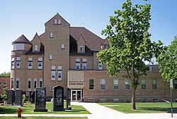
The county was established by the Minnesota legislature on March 6, 1871, with Granite Falls as the county seat. Its name comes from Yellow Medicine River, which runs through the eastern part of the county to the Minnesota. The river's name derives from a plant whose yellow root the native Dakota people used for medicinal purposes. [4]

It was proposed in 1878 to create a new county, taken from the western portions of Yellow Medicine, Lincoln, and Lac qui Parle counties. The state legislature approved the petition (subject to local voter approval), and Governor Pillsbury signed the act on February 27, 1879, but the proposal failed to garner a combined majority of votes in the three counties, and the proposed Canby County [5] did not come into being. [6]

Geography

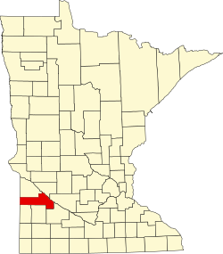
Yellow Medicine County lies on the west side of Minnesota. Its west border abuts the state of South Dakota. The Minnesota River flows east-southeast along the county's northeast side on its way to discharge into the Mississippi River. The Yellow Medicine River flows northeast through the eastern part of the county, discharging into the Minnesota near the midpoint of the county's eastern border. The Stony Run Creek flows east through the northeast part of the county; the Florida Creek flows northeast through the west end of the county, and the Lac qui Parle River also flows northeast through the west central part of the county. The county terrain consists of rolling hills, carved by drainages. The area is devoted to agriculture. [7] The terrain slopes to the east and slightly to the north; its highest point is on the west border, near its SW corner, at 1,732 ft (528 m) ASL. [8] The county has an area of 763 square miles (1,980 km2), of which 759 square miles (1,970 km2) is land and 4.1 square miles (11 km2) (0.5%) is water. [9]

Soils of Yellow Medicine County Yellow Medicine Co Pie Chart No Text Version.pdf
Soils of Yellow Medicine County

Lakes [7]

  • Burton Lake
  • Culver Lake (part)
  • Curtis Lake
  • Highbank Lake
  • Kvistid Lake
  • Lake Louie
  • Lone Tree Lake
  • Miedd Lake
  • Miller Lake
  • Mud Lake
  • Spellman Lake
  • Timm Lake
  • Tyson Lake
  • Wood Lake

Rivers and drainages [7]

Major highways

Adjacent counties

Protected areas [7]

  • Bigrock State Wildlife Management Area
  • Christopherson State Wildlife Management Area
  • Clawson State Wildlife Management Area
  • Flinks State Wildlife Management Area
  • Miller-Richter State Wildlife Management Area
  • Mound Springs Prairie Scientific and Natural Area
  • Omro State Wildlife Management Area
  • Oshkosh State Wildlife Management Area
  • Penthole State Wildlife Management Area
  • Posen State Wildlife Management Area
  • Saint Leo State Wildlife Management Area
  • Sioux Nation State Wildlife Management Area
  • Stokke State Wildlife Management Area
  • Stony Run State Wildlife Management Area
  • Swedes Forest Scientific and Natural Area (part)
  • Upper Sioux Agency State Park

Demographics

Historical population
CensusPop.Note
1880 5,884
1890 9,85467.5%
1900 14,60248.2%
1910 15,4065.5%
1920 16,5507.4%
1930 16,6250.5%
1940 16,9171.8%
1950 16,279−3.8%
1960 15,523−4.6%
1970 14,418−7.1%
1980 13,653−5.3%
1990 11,684−14.4%
2000 11,080−5.2%
2010 10,438−5.8%
2020 9,528−8.7%
2023 (est.)9,467 [11] −0.6%
U.S. Decennial Census [12]
1790-1960 [13] 1900-1990 [14]
1990-2000 [15] 2010-2020 [2]

2020 Census

Yellow Medicine County Racial Composition [16]
RaceNum.Perc.
White (NH)8,40888.3%
Black or African American (NH)480.5%
Native American (NH)2763%
Asian (NH)280.3%
Pacific Islander (NH)10.01%
Other/Mixed (NH)3193.4%
Hispanic or Latino 4484.7%

2000 census

Age pyramid of county residents based on 2000 census data USA Yellow Medicine County, Minnesota age pyramid.svg
Age pyramid of county residents based on 2000 census data

As of the census of 2000, there were 11,080 people, 4,439 households, and 2,974 families in the county. The population density was 14.6 per square mile (5.6/km2). There were 4,873 housing units at an average density of 6.42 per square mile (2.48/km2). The racial makeup of the county was 96.09% White, 0.11% Black or African American, 2.04% Native American, 0.17% Asian, 0.01% Pacific Islander, 0.92% from other races, and 0.66% from two or more races. 1.76% of the population were Hispanic or Latino of any race. 36.5% were of Norwegian and 34.6% German ancestry.

There were 4,439 households, out of which 30.30% had children under the age of 18 living with them, 58.60% were married couples living together, 5.70% had a female householder with no husband present, and 33.00% were non-families. 29.30% of all households were made up of individuals, and 15.20% had someone living alone who was 65 years of age or older. The average household size was 2.42 and the average family size was 3.01.

The county population contained 25.80% under the age of 18, 7.40% from 18 to 24, 24.20% from 25 to 44, 22.20% from 45 to 64, and 20.50% who were 65 years of age or older. The median age was 40 years. For every 100 females there were 98.20 males. For every 100 females age 18 and over, there were 94.90 males.

The median income for a household in the county was $34,393, and the median income for a family was $42,002. Males had a median income of $27,770 versus $20,870 for females. The per capita income for the county was $17,120. About 7.10% of families and 10.40% of the population were below the poverty line, including 10.40% of those under age 18 and 10.60% of those age 65 or over.

Communities

Cities

Unincorporated communities

Townships

Government and politics

Yellow Medicine County has recently been a swing county in national elections. Since 1980, the county has selected the Republican Party candidate in 56% of national elections (as of 2020). The county gave a majority to Barack Obama in 2008, but has trended more Republican in recent cycles.

United States presidential election results for Yellow Medicine County, Minnesota [17]
Year Republican Democratic Third party
No.%No.%No.%
2020 3,73467.55%1,68830.54%1061.92%
2016 3,38264.10%1,52428.89%3707.01%
2012 2,80651.83%2,46545.53%1432.64%
2008 2,57946.31%2,81650.57%1743.12%
2004 2,87849.98%2,79948.61%811.41%
2000 2,59847.11%2,52845.84%3897.05%
1996 2,00635.67%2,74148.74%87715.59%
1992 1,90930.83%2,59341.87%1,69127.31%
1988 2,92546.59%3,28252.28%711.13%
1984 3,81955.22%3,01843.64%791.14%
1980 4,00453.95%2,83338.18%5847.87%
1976 2,94639.48%4,33758.12%1792.40%
1972 3,68350.32%3,46247.30%1742.38%
1968 3,06043.34%3,58750.81%4135.85%
1964 2,75136.86%4,70763.06%60.08%
1960 3,80050.84%3,64948.82%260.35%
1956 3,59451.21%3,41648.67%80.11%
1952 4,32257.73%3,14341.99%210.28%
1948 2,69338.41%4,16459.38%1552.21%
1944 3,33750.68%3,21448.81%340.52%
1940 3,96450.89%3,78648.61%390.50%
1936 2,02930.38%3,92158.71%72910.91%
1932 1,73927.01%4,58071.14%1191.85%
1928 3,30252.96%2,86145.89%721.15%
1924 2,27838.70%1512.56%3,45858.74%
1920 4,22572.48%81413.96%79013.55%
1916 1,50150.08%1,23841.31%2588.61%
1912 35214.24%73729.81%1,38355.95%
1908 1,74565.06%78629.31%1515.63%
1904 1,94783.42%25811.05%1295.53%
1900 1,74365.95%76328.87%1375.18%
1896 1,57858.92%1,01537.90%853.17%
1892 91149.11%36419.62%58031.27%
County Board of Commissioners [18]
PositionNameDistrict
CommissionerGreg RennekeDistrict 1
CommissionerJohn BerendsDistrict 2
CommissionerMitch KlingDistrict 3
CommissionerRon AntonyDistrict 4
CommissionerGlen KackDistrict 5
State Legislature (2018-2020)
PositionNameAffiliationDistrict
Senate Gary Dahms [19] Republican District 16
House of Representatives Chris Swedzinski [20] Republican District 16A
U.S Congress (2018-2020)
PositionNameAffiliationDistrict
House of Representatives Michelle Fischbach Republican 7th
Senate Amy Klobuchar [21] Democratic N/A
Senate Tina Smith [22] Democratic N/A

See also

Related Research Articles

<span class="mw-page-title-main">Swift County, Minnesota</span> County in Minnesota, United States

Swift County is a county in the U.S. state of Minnesota. As of the 2020 census, the population was 9,838. Its county seat is Benson.

<span class="mw-page-title-main">Redwood County, Minnesota</span> County in Minnesota, United States

Redwood County is a county in the U.S. state of Minnesota. As of the 2020 census the population was 15,425. Its county seat is Redwood Falls, along the Redwood River near its confluence with the Minnesota River.

<span class="mw-page-title-main">Nobles County, Minnesota</span> County in Minnesota, United States

Nobles County is a county in the U.S. state of Minnesota. As of the 2020 census, the population was 22,290. Its county seat is Worthington. Nobles County comprises the Worthington, MN Micropolitan Statistical Area.

<span class="mw-page-title-main">Morrison County, Minnesota</span> County in Minnesota, United States

Morrison County is a county in the U.S. state of Minnesota. As of the 2020 census, the population was 34,010. Its county seat is Little Falls. Camp Ripley Military Reservation occupies a significant area in north-central Morrison County.

<span class="mw-page-title-main">Mille Lacs County, Minnesota</span> County in Minnesota, United States

Mille Lacs County is a county in the East Central part of the U.S. state of Minnesota. As of the 2020 census, the population was 26,459. Its county seat is Milaca. The county was founded in 1857, and its boundary was expanded in 1860.

<span class="mw-page-title-main">Lyon County, Minnesota</span> County in Minnesota, United States

Lyon County is a county in the U.S. state of Minnesota. As of the 2020 census, the population was 25,269. Its county seat is Marshall.

<span class="mw-page-title-main">Lincoln County, Minnesota</span> County in Minnesota, United States

Lincoln County is a county in the U.S. state of Minnesota. As of the 2020 census, the population was 5,640. Its county seat is Ivanhoe.

<span class="mw-page-title-main">Lac qui Parle County, Minnesota</span> County in Minnesota, United States

Lac qui Parle County is a county in the southwestern part of the U.S. state of Minnesota. As of the 2020 census, the population was 6,719. Its county seat is Madison. The largest city in the county is Dawson.

<span class="mw-page-title-main">Jackson County, Minnesota</span> County in Minnesota, United States

Jackson County is a county in the U.S. state of Minnesota. As of the 2020 census, the population was 9,989. Its county seat is Jackson.

<span class="mw-page-title-main">Grant County, Minnesota</span> County in Minnesota, United States

Grant County is a county in the U.S. state of Minnesota. As of the 2020 census, the population was 6,074. Its county seat is Elbow Lake.

<span class="mw-page-title-main">Clearwater County, Minnesota</span> County in Minnesota, United States

Clearwater County is a county in the northwestern part of the U.S. state of Minnesota. As of the 2020 census, the population was 8,524. Its county seat is Bagley.

<span class="mw-page-title-main">Chippewa County, Minnesota</span> County in Minnesota, United States

Chippewa County is a county in the U.S. state of Minnesota. As of the 2020 census, the population was 12,598. Its county seat is Montevideo. The county was formed in 1862, and was organized in 1868.

<span class="mw-page-title-main">Carlton County, Minnesota</span> County in Minnesota, United States

Carlton County is a county in the State of Minnesota, formed in 1857. As of the 2020 census, the population was 36,207. Its county seat is Carlton. Part of the Fond du Lac Indian Reservation lies in northeastern Carlton County.

<span class="mw-page-title-main">Brown County, Minnesota</span> County in Minnesota, United States

Brown County is a county in the U.S. state of Minnesota. As of the 2020 census, the population was 25,912. Its county seat is New Ulm. The county was formed in 1855 and organized in 1856.

<span class="mw-page-title-main">Big Stone County, Minnesota</span> County in Minnesota, United States

Big Stone County is a county in the U.S. state of Minnesota. As of the 2020 census, the population was 5,166. Its county seat is Ortonville.

<span class="mw-page-title-main">Aitkin County, Minnesota</span> County in Minnesota, United States

Aitkin County is a county in the U.S. state of Minnesota. As of the 2020 census, the population was 15,697. Its county seat is Aitkin. Part of the Mille Lacs Indian Reservation is in the county. The county was created in 1857 and organized in 1871.

Odessa Township is a township in Big Stone County, Minnesota, United States. The population was 147 as of the 2000 census. Odessa Township was named after Odesa, Ukraine.

Maxwell Township is a township in Lac qui Parle County, Minnesota, United States. The population was 206 at the 2000 census.

Providence Township is a township in Lac qui Parle County, Minnesota, United States. The population was 186 at the 2000 census.

<span class="mw-page-title-main">Lac qui Parle River</span> River in Minnesota, United States

The Lac qui Parle River is a tributary of the Minnesota River, 118 miles (190 km) long, in southwestern Minnesota in the United States. A number of tributaries of the river, including its largest, the West Branch Lac qui Parle River, also flow in eastern South Dakota. Via the Minnesota River, the Lac qui Parle River is part of the watershed of the Mississippi River, draining an area of 1,156 square miles (2,990 km2) in an agricultural region. Slightly more than two-thirds of the Lac qui Parle watershed is in Minnesota. Lac qui parle means "lake which speaks" in the French language, and was a translation of the Sioux name for Lac qui Parle, a lake on the Minnesota River upstream of the mouth of the Lac qui Parle River.

References

  1. Upham, Warren (1920). Minnesota Geographic Names: Their Origin and Historic Significance. Minnesota Historical Society. p.  593.
  2. 1 2 "State & County QuickFacts". United States Census Bureau. Retrieved April 15, 2023.
  3. "Find a County". National Association of Counties. Retrieved June 7, 2011.
  4. History of Yellow Medicine County Archived August 14, 2006, at the Wayback Machine , Yellow Medicine County website, accessed May 25, 2010
  5. Gramarly.com
  6. Upham, Warren. Minnesota Geographic Names, p. 593 (1920). Accessed March 13, 2019
  7. 1 2 3 4 Yellow Medicine County MN Google Maps (accessed March 13, 2019
  8. "Find an Altitude/Yellow Medicine County MN" Google Maps (accessed March 13, 2019)
  9. "2010 Census Gazetteer Files". United States Census Bureau. August 22, 2012. Archived from the original on October 6, 2014. Retrieved October 25, 2014.
  10. Nelson, Steven (2011). Savanna Soils of Minnesota. Minnesota: Self. pp. 69-70. ISBN   978-0-615-50320-2.
  11. "Annual Estimates of the Resident Population for Counties: April 1, 2020 to July 1, 2023" . Retrieved March 18, 2024.
  12. "U.S. Decennial Census". United States Census Bureau. Retrieved October 25, 2014.
  13. "Historical Census Browser". University of Virginia Library. Retrieved October 25, 2014.
  14. "Population of Counties by Decennial Census: 1900 to 1990". United States Census Bureau. Retrieved October 25, 2014.
  15. "Census 2000 PHC-T-4. Ranking Tables for Counties: 1990 and 2000" (PDF). United States Census Bureau. Archived (PDF) from the original on March 27, 2010. Retrieved October 25, 2014.
  16. "P2 HISPANIC OR LATINO, AND NOT HISPANIC OR LATINO BY RACE – 2020: DEC Redistricting Data (PL 94-171) – Yellow Medicine County, Minnesota".
  17. Leip, David. "Atlas of US Presidential Elections". uselectionatlas.org. Retrieved October 10, 2018.
  18. "County Commissioners - Yellow Medicine County, MN". www.co.ym.mn.gov. Retrieved April 25, 2023.
  19. "MN State Senate". www.senate.mn. Retrieved June 25, 2020.
  20. "Rep. Chris Swedzinski (16A) - Minnesota House of Representatives". www.house.leg.state.mn.us. Retrieved June 25, 2020.
  21. "U.S. Senator Amy Klobuchar". www.klobuchar.senate.gov. Retrieved June 24, 2020.
  22. "Home". Senator Tina Smith. Retrieved June 24, 2020.

44°43′N95°52′W / 44.72°N 95.86°W / 44.72; -95.86