St. Leo, Minnesota

Last updated

St. Leo, Minnesota
Nickname: 
Swamp Town
Yellow Medicine County Minnesota Incorporated and Unincorporated areas St. Leo Highlighted.svg
Location of St. Leo
within Yellow Medicine County, Minnesota
Coordinates: 44°43′02″N96°03′09″W / 44.71722°N 96.05250°W / 44.71722; -96.05250
CountryUnited States
State Minnesota
County Yellow Medicine
Incorporated June 6, 1940
Government
   Mayor David (Bubba) Gorecki
Area
[1]
  Total0.253 sq mi (0.655 km2)
  Land0.253 sq mi (0.655 km2)
  Water0.000 sq mi (0.000 km2)
Elevation
[2]
1,119 ft (341 m)
Population
 (2020) [3]
  Total93
  Estimate 
(2022) [4]
93
  Density367.59/sq mi (142.01/km2)
Time zone UTC–6 (Central (CST))
  Summer (DST) UTC–5 (CDT)
ZIP Code
56264
Area code 507
FIPS code 27-57202
GNIS feature ID2396499 [2]
Sales tax 6.875% [5]

St. Leo or Saint Leo is a city in Yellow Medicine County, Minnesota, United States. The population was 93 at the 2020 census. [3]

Contents

History

A post office called Saint Leo was established in 1880, and remained in operation until 1991. [6] The city was named for Pope Leo I (d. 461). [7]

Geography

According to the United States Census Bureau, the city has a total area of 0.253 square miles (0.66 km2), all land. [1]

County Roads 3 and 11 are the main routes in the community.

Demographics

Historical population
CensusPop.Note
1950 128
1960 1290.8%
1970 15318.6%
1980 147−3.9%
1990 111−24.5%
2000 106−4.5%
2010 100−5.7%
2020 93−7.0%
2022 (est.)93 [4] 0.0%
U.S. Decennial Census [8]
2020 Census [3]

2010 census

As of the 2010 census, there were 100 people, 51 households, and 26 families living in the city. The population density was 384.6 inhabitants per square mile (148.5/km2). There were 58 housing units at an average density of 223.1 per square mile (86.1/km2). The racial makeup of the city was 98.0% White and 2.0% from two or more races. Hispanic or Latino of any race were 5.0% of the population.

There were 51 households, of which 19.6% had children under the age of 18 living with them, 41.2% were married couples living together, 3.9% had a female householder with no husband present, 5.9% had a male householder with no wife present, and 49.0% were non-families. 43.1% of all households were made up of individuals, and 17.7% had someone living alone who was 65 years of age or older. The average household size was 1.96 and the average family size was 2.65.

The median age in the city was 49.5 years. 17% of residents were under the age of 18; 9% were between the ages of 18 and 24; 16% were from 25 to 44; 25% were from 45 to 64; and 33% were 65 years of age or older. The gender makeup of the city was 58.0% male and 42.0% female.

2000 census

As of the 2000 census, there were 106 people, 54 households, and 30 families living in the city. The population density was 404.0 inhabitants per square mile (156.0/km2). There were 57 housing units at an average density of 217.2 per square mile (83.9/km2). The racial makeup of the city was 98.11% White and 1.89% Native American.

There were 54 households, out of which 13.0% had children under the age of 18 living with them, 51.9% were married couples living together, 3.7% had a female householder with no husband present, and 42.6% were non-families. 40.7% of all households were made up of individuals, and 18.5% had someone living alone who was 65 years of age or older. The average household size was 1.96 and the average family size was 2.65.

In the city, the population was spread out, with 12.3% under the age of 18, 6.6% from 18 to 24, 24.5% from 25 to 44, 19.8% from 45 to 64, and 36.8% who were 65 years of age or older. The median age was 51 years. For every 100 females, there were 92.7 males. For every 100 females age 18 and over, there were 97.9 males.

The median income for a household in the city was $23,125, and the median income for a family was $40,000. Males had a median income of $19,375 versus $14,375 for females. The per capita income for the city was $15,275. There were 7.1% of families and 11.4% of the population living below the poverty line, including 11.8% of under eighteens and 5.3% of those over 64.

Related Research Articles

<span class="mw-page-title-main">Watertown, Minnesota</span> City in Minnesota, United States

Watertown is a small city in Carver County, Minnesota, United States, along the South Fork of the Crow River, on the outskirts of the Twin Cities metro area. The population was 4,659 at the 2020 census.

<span class="mw-page-title-main">Backus, Minnesota</span> City in Minnesota, United States

Backus is a city in Cass County, Minnesota, United States. The population was 250 at the 2010 census. It is part of the Brainerd Micropolitan Statistical Area.

<span class="mw-page-title-main">Lake Shore, Minnesota</span> City in Minnesota, United States

Lake Shore is a city in Cass County, Minnesota, United States. The population was 1,056 at the 2020 census. It is part of the Brainerd Micropolitan Statistical Area.

<span class="mw-page-title-main">Emily, Minnesota</span> City in Minnesota, United States

Emily is a city in Crow Wing County, Minnesota, United States. The population was 843 at the 2020 census. It is part of the Brainerd Micropolitan Statistical Area.

<span class="mw-page-title-main">Trommald, Minnesota</span> City in Minnesota, United States

Trommald is a city in Crow Wing County, Minnesota, United States. The population was 99 at the 2020 census. It is part of the Brainerd Micropolitan Statistical Area.

<span class="mw-page-title-main">Garfield, Minnesota</span> City in Minnesota, United States

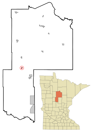
Garfield is a city in Douglas County, Minnesota, United States. The population was 349 at the 2020 census.

<span class="mw-page-title-main">Isanti, Minnesota</span> City in the United States

Isanti is a city in Isanti County, Minnesota, United States. The population was 6,804 at the 2020 census. The name Isanti is composed of two Dakota words: isan ("knife") and ati ("camp"), and refers to the Santee Dakota people.

<span class="mw-page-title-main">Sunburg, Minnesota</span> City in Minnesota, United States

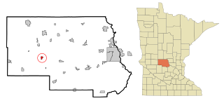
Sunburg is a city in Kandiyohi County, Minnesota, United States. The population was 94 at the 2020 census.

<span class="mw-page-title-main">Lake Bronson, Minnesota</span> City in Minnesota, United States

Lake Bronson is a city in Kittson County, Minnesota, United States. The population was 178 at the 2020 census. Lake Bronson State Park is nearby.

<span class="mw-page-title-main">Deer Creek, Minnesota</span> City in Minnesota, United States

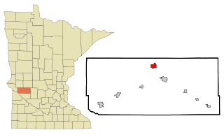
Deer Creek is a city in Otter Tail County, Minnesota, United States. The population was 330 at the 2020 census.

<span class="mw-page-title-main">Erhard, Minnesota</span> City in Minnesota, United States

Erhard is a city in Otter Tail County, Minnesota, United States. The population was 132 at the 2020 census.

<span class="mw-page-title-main">Henning, Minnesota</span> City in Minnesota, United States

Henning is a city in Otter Tail County, Minnesota, United States. The population was 854 at the 2020 census.

<span class="mw-page-title-main">Urbank, Minnesota</span> City in Minnesota, United States

Urbank is a city in Otter Tail County, Minnesota, United States. The population was 52 at the 2020 census.

<span class="mw-page-title-main">Maplewood, Minnesota</span> City in Minnesota, United States

Maplewood is a city in Ramsey County, Minnesota, United States. The population was 42,088 at the 2020 census. Maplewood is ten minutes' drive from downtown Saint Paul. It stretches along the northern and eastern borders of Saint Paul.

<span class="mw-page-title-main">Clontarf, Minnesota</span> City in Minnesota, United States

Clontarf is a city in Swift County, Minnesota, United States. The population was 164 at the 2010 census.

<span class="mw-page-title-main">Grant, Minnesota</span> City in Minnesota, United States

Grant is a city in Washington County, Minnesota, and a suburb of St. Paul. The population was 4,096 at the time of the 2010 census.

<span class="mw-page-title-main">Federal Dam, Minnesota</span> City in Minnesota, United States

Federal Dam is a city in Cass County, Minnesota, United States, near Leech Lake. The population was 110 at the 2010 census. It is part of the Brainerd Micropolitan Statistical Area.

<span class="mw-page-title-main">Spring Hill, Minnesota</span> City in Minnesota, United States

Spring Hill is a city in Stearns County, Minnesota, United States. The population was 85 at the 2010 census. It is part of the St. Cloud Metropolitan Statistical Area.

<span class="mw-page-title-main">Minnesota Lake, Minnesota</span> City in Minnesota, United States

Minnesota Lake is a city in Blue Earth and Faribault counties in the State of Minnesota. The population was 661 at the 2020 census. The bulk of the city is in Faribault County; a small part extends into Blue Earth County.

<span class="mw-page-title-main">Minneiska, Minnesota</span> City in Minnesota, United States

Minneiska is a city in Wabasha and Winona counties in the U.S. state of Minnesota. The population was 97 at the 2020 census.

References

  1. 1 2 "2023 U.S. Gazetteer Files". United States Census Bureau. Retrieved July 24, 2022.
  2. 1 2 U.S. Geological Survey Geographic Names Information System: St. Leo, Minnesota
  3. 1 2 3 "Explore Census Data". United States Census Bureau . Retrieved February 8, 2024.
  4. 1 2 "City and Town Population Totals: 2020-2022". United States Census Bureau. February 8, 2024. Retrieved February 8, 2024.
  5. "St. Leo (MN) sales tax rate" . Retrieved February 8, 2024.
  6. "Yellow Medicine County". Jim Forte Postal History. Retrieved August 16, 2015.
  7. Upham, Warren (1920). Minnesota Geographic Names: Their Origin and Historic Significance. Minnesota Historical Society. p.  596.
  8. "Census of Population and Housing". census.gov. Retrieved June 4, 2015.