Porter, Minnesota

Last updated

Porter, Minnesota
Lone Tree, Harstad, Dalston
Yellow Medicine County Minnesota Incorporated and Unincorporated areas Porter Highlighted.svg
Location of Porter, Minnesota
Coordinates: 44°38′34″N96°10′04″W / 44.64278°N 96.16778°W / 44.64278; -96.16778
CountryUnited States
State Minnesota
County Yellow Medicine
PlattedOctober 1881
Incorporated February 16, 1898
Named for L. C. Porter
Government
  TypeCity Council
   Mayor Donald J. Verschelde
Area
[1]
  Total1.998 sq mi (5.175 km2)
  Land1.996 sq mi (5.169 km2)
  Water0.002 sq mi (0.062 km2)
Elevation
[2]
1,194 ft (364 m)
Population
 (2020) [3]
  Total166
  Estimate 
(2022) [4]
165
  Density83.17/sq mi (32.11/km2)
Time zone UTC–6 (Central (CST))
  Summer (DST) UTC–5 (CDT)
ZIP Code
56280
Area code 507
FIPS code 27-52144
GNIS feature ID2396257 [2]
Sales tax 6.875% [5]
Website portermn.org

Porter is a city in Yellow Medicine and Lincoln counties, Minnesota, United States. The population was 166 at the 2020 census. [3]

Contents

History

Porter was platted in October 1881 when the Winona and St. Peter Railroad was extended to that point. [6] It was named for L. C. Porter, a mill owner and early settler. [6] A post office has been in operation in Porter since 1882. [7] Porter was incorporated on February 16, 1898. [8]

Geography

According to the United States Census Bureau, the city has a total area of 1.998 square miles (5.17 km2), all land. [1] The North Branch of the Yellow Medicine River flows through the city. [9]

Demographics

Historical population
CensusPop.Note
1900 196
1910 25329.1%
1920 2571.6%
1930 2632.3%
1940 250−4.9%
1950 29116.4%
1960 261−10.3%
1970 207−20.7%
1980 2111.9%
1990 210−0.5%
2000 190−9.5%
2010 183−3.7%
2020 166−9.3%
2022 (est.)165 [4] −0.6%
U.S. Decennial Census [10]
2020 Census [3]

2010 census

As of the 2010 census, there were 183 people, 86 households, and 47 families residing in the city. The population density was 79.9 inhabitants per square mile (30.8/km2). There were 97 housing units at an average density of 42.4 per square mile (16.4/km2). The racial makeup of the city was 99.5% White and 0.5% Asian. Hispanic or Latino of any race were 1.1% of the population.

There were 86 households, of which 23.3% had children under the age of 18 living with them, 45.3% were married couples living together, 4.7% had a female householder with no husband present, 4.7% had a male householder with no wife present, and 45.3% were non-families. 37.2% of all households were made up of individuals, and 18.6% had someone living alone who was 65 years of age or older. The average household size was 2.13 and the average family size was 2.83.

The median age in the city was 39.8 years. 21.9% of residents were under the age of 18; 7.7% were between the ages of 18 and 24; 24% were from 25 to 44; 32.2% were from 45 to 64; and 14.2% were 65 years of age or older. The gender makeup of the city was 50.8% male and 49.2% female.

2000 census

As of the 2000 census, there were 190 people, 88 households, and 54 families residing in the city. The population density was 85.2 inhabitants per square mile (32.9/km2). There were 98 housing units at an average density of 44.0 per square mile (17.0/km2). The racial makeup of the city was 97.37% White, 1.05% African American and 1.58% Native American.

There were 88 households, out of which 28.4% had children under the age of 18 living with them, 48.9% were married couples living together, 4.5% had a female householder with no husband present, and 38.6% were non-families. 37.5% of all households were made up of individuals, and 20.5% had someone living alone who was 65 years of age or older. The average household size was 2.16 and the average family size was 2.74.

In the city, the population was spread out, with 20.5% under the age of 18, 11.1% from 18 to 24, 28.4% from 25 to 44, 23.2% from 45 to 64, and 16.8% who were 65 years of age or older. The median age was 40 years. For every 100 females, there were 93.9 males. For every 100 females age 18 and over, there were 98.7 males.

The median income for a household in the city was $21,250, and the median income for a family was $27,000. Males had a median income of $23,875 versus $21,500 for females. The per capita income for the city was $12,910. About 17.7% of families and 18.1% of the population were below the poverty line, including 22.2% of those under the age of eighteen and 20.6% of those 65 or over.

Community

Porter was founded in 1881 by Scandinavian settlers. The town's heritage is still celebrated today with the annual Lutefisk, Lefse and Swedish Meatball Supper at Bethel Lutheran Church (Porter Norwegian Lutheran Church) in early November.

Auctions highlight a tradition in Porter. In January the long-standing Porter March of Dimes auction takes place at the Porter Community Hall. The fundraiser has been an annual event for over 70 years. Porter celebrates its annual Market Day Sale in April. The annual auction draws thousands to the town and shuts down streets for auction rings. The auction is a pre-World War II tradition that carries on to this day. As has been tradition for the over 90 years of the auction, homemade pies and sandwiches are still served in the Porter Community Hall by the Bethel Lutheran Church and food stands are operated by the Deb's Café and various Porter organizations throughout the auction grounds.

In August the community celebrates the bountiful harvests of the community with our Harvest Festival. The event has been held on the 3rd weekend in August for over 50 years.

Related Research Articles

<span class="mw-page-title-main">Good Thunder, Minnesota</span> City in Minnesota, United States

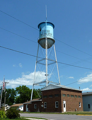
Good Thunder is a city in Blue Earth County, Minnesota, United States, situated along the Maple River. The population was 560 at the 2020 census. It is part of the Mankato–North Mankato Metropolitan Statistical Area.

<span class="mw-page-title-main">Clara City, Minnesota</span> City in Minnesota, United States

Clara City is a city in Chippewa County, Minnesota, United States. The population was 1,360 at the 2010 census.

<span class="mw-page-title-main">Storden, Minnesota</span> City in Minnesota, United States

Storden is a city in Cottonwood County, Minnesota, United States. The population was 219 at the 2010 census.

<span class="mw-page-title-main">Hayfield, Minnesota</span> City in Minnesota, United States

Hayfield is a city in Dodge County, Minnesota, United States. The population was 1,340 at the 2010 census.

<span class="mw-page-title-main">Bricelyn, Minnesota</span> City in Minnesota, United States

Bricelyn is a city in Faribault County, Minnesota, United States. The population was 365 at the 2010 census.

<span class="mw-page-title-main">Zumbrota, Minnesota</span> City in Minnesota, United States

Zumbrota is a city in Goodhue County, Minnesota, United States, along the North Fork of the Zumbro River. The population was 3,252 at the 2010 census. It promotes itself as "the only Zumbrota in the world."

<span class="mw-page-title-main">Wendell, Minnesota</span> City in Minnesota, United States

Wendell is a city in Grant County, Minnesota, United States. The population was 167 at the 2010 census.

<span class="mw-page-title-main">Caledonia, Minnesota</span> City in Minnesota, United States

Caledonia is a city and the county seat of Houston County, Minnesota, United States and is part of the La Crosse, Wisconsin Metropolitan Statistical Area. The population was 2,847 at the 2020 census.

<span class="mw-page-title-main">Avoca, Minnesota</span> City in Minnesota, United States

Avoca is a city in Murray County, Minnesota, United States. The population was 111 at the 2020 census.

Anthony Township is a township in Norman County, Minnesota. As of the 2000 census, the population was 85.

<span class="mw-page-title-main">Henning, Minnesota</span> City in Minnesota, United States

Henning is a city in Otter Tail County, Minnesota, United States. The population was 854 at the 2020 census.

<span class="mw-page-title-main">Glenwood, Minnesota</span> City in Minnesota, United States

Glenwood is a city in, and the county seat of, Pope County, Minnesota, United States. The population was 2,657 at the 2020 census. It is located on the northeastern shore of Lake Minnewaska.

<span class="mw-page-title-main">Charlestown Township, Redwood County, Minnesota</span> Township in Minnesota, United States

Charlestown Township is one of the twenty-six townships of Redwood County, Minnesota, United States. The population was 217 at the 2000 census.

<span class="mw-page-title-main">Franklin, Minnesota</span> City in Minnesota, United States

Franklin is a city in Renville County, Minnesota, United States. The population was 510 at the 2010 census.

<span class="mw-page-title-main">Arlington, Minnesota</span> City in Minnesota, United States

Arlington is a city in Sibley County, Minnesota, United States. The population was 2,233 at the 2010 census.

<span class="mw-page-title-main">Millville, Minnesota</span> City in Minnesota, United States

Millville is a city along the Zumbro River in Wabasha County, Minnesota, United States. The population was 182 at the 2010 census.

<span class="mw-page-title-main">Lewiston, Minnesota</span> City in Minnesota, United States

Lewiston is a city in Winona County, Minnesota, United States. The population was 1,620 at the 2010 census.

Marysville Township is a township in Wright County, Minnesota, United States. The population was 2,097 at the 2000 census.

<span class="mw-page-title-main">Center City, Minnesota</span> City in Minnesota, United States

Center City is a city and the county seat of Chisago County, Minnesota, United States. The population was 628 at the 2010 census.

<span class="mw-page-title-main">Minnesota Lake, Minnesota</span> City in Minnesota, United States

Minnesota Lake is a city in Blue Earth and Faribault counties in the State of Minnesota. The population was 661 at the 2020 census. The bulk of the city is in Faribault County; a small part extends into Blue Earth County.

References

  1. 1 2 "2023 U.S. Gazetteer Files". United States Census Bureau. Retrieved July 24, 2022.
  2. 1 2 U.S. Geological Survey Geographic Names Information System: Porter, Minnesota
  3. 1 2 3 "Explore Census Data". United States Census Bureau . Retrieved February 8, 2024.
  4. 1 2 "City and Town Population Totals: 2020-2022". United States Census Bureau. February 8, 2024. Retrieved February 8, 2024.
  5. "Porter (MN) sales tax rate" . Retrieved February 8, 2024.
  6. 1 2 Chicago and North Western Railway Company (1908). A History of the Origin of the Place Names Connected with the Chicago & North Western and Chicago, St. Paul, Minneapolis & Omaha Railways. p. 115.
  7. "Yellow Medicine County". Jim Forte Postal History. Retrieved March 22, 2015.
  8. Upham, Warren (1920). Minnesota Geographic Names: Their Origin and Historic Significance. Minnesota Historical Society. p.  596.
  9. Minnesota Atlas & Gazetteer. Yarmouth, Maine: DeLorme. 1994. p. 28. ISBN   0-89933-222-6.
  10. "Census of Population and Housing". census.gov. Retrieved June 4, 2015.