Lorne, Minnesota | |
---|---|
Unincorporated community | |
Coordinates: 44°44′46″N95°34′28″W / 44.74611°N 95.57444°W Coordinates: 44°44′46″N95°34′28″W / 44.74611°N 95.57444°W | |
Country | United States |
State | Minnesota |
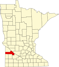
County | Yellow Medicine |
Elevation | 1,050 ft (320 m) |
Time zone | Central (CST) (UTC-6) |
• Summer (DST) | CDT (UTC-5) |
Area code(s) | 320 |
GNIS feature ID | 654805 [1] |
Lorne is an unincorporated community in Minnesota Falls Township, Yellow Medicine County, in the U.S. state of Minnesota. [1]
Minnesota Falls Township is a township in Yellow Medicine County, Minnesota, United States. The population was 361 at the 2000 census.
Yellow Medicine County is a county in the State of Minnesota. Its eastern border is formed by the Minnesota River. As of the 2010 United States Census, the population was 10,438. Its county seat is Granite Falls.
In the United States, a state is a constituent political entity, of which there are currently 50. Bound together in a political union, each state holds governmental jurisdiction over a separate and defined geographic territory and shares its sovereignty with the federal government. Due to this shared sovereignty, Americans are citizens both of the federal republic and of the state in which they reside. State citizenship and residency are flexible, and no government approval is required to move between states, except for persons restricted by certain types of court orders. Four states use the term commonwealth rather than state in their full official names.
Lorne was laid out in 1898, and named for Marquess of Lorne, a Governor General of Canada (1878–1883). [2] A post office was established at Lorne in 1905, and remained in operation until 1935. [3]
John George Edward Henry Douglas Sutherland Campbell, 9th Duke of Argyll,, usually better known by the courtesy title Marquess (Marquis) of Lorne, by which he was known between 1847 and 1900, was a British nobleman and was the fourth Governor General of Canada from 1878 to 1883. He is now remembered primarily for the place names bestowed on Canadian geography in honour of his wife and for his metrical paraphrase of Psalm 121, "Unto the hills around do I lift up".
Lyon County is a county in the U.S. state of Minnesota. As of the 2010 United States Census, the population was 25,857. Its county seat is Marshall.
Lac qui Parle County is a county in the U.S. state of Minnesota. As of the 2010 United States Census, the population was 7,259. Its county seat is Madison.
Sioux Agency Township is a township in Yellow Medicine County, Minnesota, United States. The population was 237 at the 2000 census.
Granite Falls is a city in Chippewa and Yellow Medicine counties in the State of Minnesota. The population was 2,897 at the 2010 census. It is the county seat of Yellow Medicine County. The Andrew John Volstead House, a National Historic Landmark, is located in Granite Falls.
The Yellow Medicine River is a tributary of the Minnesota River, 107 miles (173 km) long, in southwestern Minnesota in the United States. Via the Minnesota River, it is part of the watershed of the Mississippi River, draining an area of 665 square miles (1,722 km²) in an agricultural region. Its name is a translation of the Dakota name for the river, pajutazee,,
The Lac qui Parle River is a tributary of the Minnesota River, 118 miles (190 km) long, in southwestern Minnesota in the United States. A number of tributaries of the river, including its largest, the West Branch Lac qui Parle River, also flow in eastern South Dakota. Via the Minnesota River, the Lac qui Parle River is part of the watershed of the Mississippi River, draining an area of 1,156 square miles (2,990 km2) in an agricultural region. Slightly more than two-thirds of the Lac qui Parle watershed is in Minnesota. Lac qui parle means "the lake which speaks" in the French language, and was a translation of the Sioux name for Lac qui Parle, a lake on the Minnesota River upstream of the mouth of the Lac qui Parle River.
The Upper Sioux Indian Reservation, or Pezihutazizi in Dakota, is the reservation of the Upper Sioux Community, a federally recognized tribe of the Dakota people, that includes the Mdewakanton.
Yellow Medicine East High School is a small town high school located at 450 9th Avenue, Granite Falls, Yellow Medicine County, Minnesota. As of the 2009-2010 academic year, the school had 263 students. The school mascot is the "Sting," which resembles the Georgia Tech Yellow Jacket. The Yellow Medicine East school district is the result of the merger of neighboring communities' schools. The majority of students from Granite Falls, Clarkfield, Hazel Run, Hanley Falls, Echo attend Yellow Medicine East Schools.
Lake Shaokatan is a lake in Lincoln County, in the U.S. state of Minnesota.. The Minnesota DNR identifies the lake as ID 41008900. It is a "sentinel" lake of 996 acres.
Tyson Lake is a lake in Yellow Medicine County, in the U.S. state of Minnesota.
Spring Creek is a small river in southwestern Minnesota. It is a headwater to the Yellow Medicine River, which is a tributary to the Minnesota River. Springs are part of the source of the creek's water, hence the name. In the winter, the springs may cause the ice to be thinner and weaker over and downstream of the spring. Spring Creek has a perennial length of 33.4 miles (53.8 km), and can reach a total length of 46 miles (74 km) when conditions permit. Spring Creek flows entirely within the boundaries of Yellow Medicine County.
Wood Lake is a lake near the town of Wood Lake, Minnesota in Yellow Medicine County.
The Yellow Bank River is a 12.0-mile-long (19.3 km) tributary of the Minnesota River in western Minnesota in the United States. It is formed by the confluence of two longer streams, the North Fork Yellow Bank River and the South Fork Yellow Bank River, which also flow in northeastern South Dakota. Via the Minnesota River, the Yellow Bank River is part of the watershed of the Mississippi River, draining an area of approximately 460 square miles (1,190 km²) in an agricultural region.
Libby is an unincorporated community in Libby Township, Aitkin County, Minnesota, United States. The community is located between McGregor and Jacobson along State Highway 65. The Mississippi River flows nearby. Libby is located immediately northwest of Big Sandy Lake.
Burr is an unincorporated community in Florida Township, Yellow Medicine County, in the U.S. state of Minnesota.
Stony Run Creek is a stream in Yellow Medicine County, in the U.S. state of Minnesota.
Canby Creek is a stream in Yellow Medicine County, in the U.S. state of Minnesota.
Normania is an unincorporated community in Normania Township, Yellow Medicine County, Minnesota, United States.
Spring Creek is an unincorporated community in Friendship Township, Yellow Medicine County, Minnesota, United States.
This article about a location in Yellow Medicine County, Minnesota is a stub. You can help Wikipedia by expanding it. |