
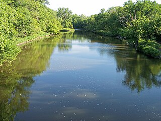
The Red Cedar River is a tributary of the Grand River in central Michigan in the United States. The river is approximately 51.1 miles (82.2 km) long and drains a watershed of approximately 461 square miles (1,190 km2) in the Lansing–East Lansing metropolitan area and suburban and rural areas to the east.

The Souris River or Mouse River is a river in central North America. It is about 700 km (435 mi) in length and drains about 23,600 square miles (61,100 km2). It rises in the Yellow Grass Marshes north of Weyburn, Saskatchewan. It wanders south through North Dakota beyond Minot to its most southern point at the city of Velva, and then back north into Manitoba. The river passes through the communities of Melita, Hartney, Souris and Wawanesa and on to its confluence with the Assiniboine River near Treesbank, about 25 miles (40 km) south east of Brandon. The main tributaries which flow into the Souris in Manitoba are the Antler River, the Gainsborough and Plum Creeks. Much of its drainage basin is fertile silt and clay deposited by former glacial Lake Souris.

Oatka Creek is the third longest tributary of the Genesee River, located entirely in the Western New York region of the U.S. state of New York. From southern Wyoming County, it flows 58 miles (93 km) to the Genesee near Scottsville, draining an area of 215 square miles (560 km2) that includes all or part of 23 towns and villages in Wyoming, Genesee, Livingston and Monroe counties as well. Its name means "leaving the highlands" or "approaching an opening" in Seneca.

Rock Creek is a free-flowing tributary of the Potomac River that empties into the Atlantic Ocean via the Chesapeake Bay. The 32.6-mile (52.5 km) creek drains about 76.5 square miles (198 km2). Its final quarter-mile is affected by tides.

Canadarago Lake is a 1,917-acre (7.76 km2) lake located in Otsego County, New York and is the source of Oaks Creek. The Village of Richfield Springs is located at the lake's northern end. It is the second largest lake in Otsego County, lying to the west of and parallel to the larger Otsego Lake. The lake's name is also spelled "Candajarago Lake" or "Caniadaraga Lake".

Okamanpeedan Lake, partially located in Martin County, Minnesota, and Emmet County, Iowa, is also known as Tuttle Lake. Okamanpeedan Lake is a roughly 2,300-acre (9.3 km²) riverine lake located on the East Fork of the Des Moines River. It has an average depth of about four to six feet. The lake has a contributing watershed of approximately 120,056 acres (486 km²) and watershed:lake ratio on the order of about 50:1. The lake is situated in a glacial till plain and is generally in an area dominated by loamy, poorly drained soils. The area is primarily level but does have some rolling hills.
The Yellow Medicine River is a tributary of the Minnesota River, 107 miles (173 km) long, in southwestern Minnesota in the United States. Via the Minnesota River, it is part of the watershed of the Mississippi River, draining an area of 665 square miles (1,722 km²) in an agricultural region. Its name is a translation of the Dakota name for the river, pajutazee,,

The Lac qui Parle River is a tributary of the Minnesota River, 118 miles (190 km) long, in southwestern Minnesota in the United States. A number of tributaries of the river, including its largest, the West Branch Lac qui Parle River, also flow in eastern South Dakota. Via the Minnesota River, the Lac qui Parle River is part of the watershed of the Mississippi River, draining an area of 1,156 square miles (2,990 km2) in an agricultural region. Slightly more than two-thirds of the Lac qui Parle watershed is in Minnesota. Lac qui parle means "the lake which speaks" in the French language, and was a translation of the Sioux name for Lac qui Parle, a lake on the Minnesota River upstream of the mouth of the Lac qui Parle River.

Lake of the Isles is a lake in Minneapolis, Minnesota, United States, connected to Cedar Lake and Bde Maka Ska. In winter it is used for ice skating and hockey and serves as the location of a New Year's Eve celebration featuring roasted marshmallows and hot chocolate. The lake has an area of 109 acres (0.4 km2), 2.86 miles (4.6 km) of shoreline with a little under three miles of paved walking and biking paths, and a maximum depth of 31 feet (9 m).
Cootes Paradise at the western end of Lake Ontario is a property of the Royal Botanical Gardens and a remnant of the larger Dundas Marsh Crown Game Preserve established by the Province of Ontario in 1927. Cootes Paradise Marsh is a 4.5km long rivermouth wetland within this property and represent the lakes western terminus. It is found on the west side of Hamilton Harbour and It is located in the municipality of Hamilton, Ontario, Canada. It is owned and managed by Royal Botanical Gardens (RBG), a charitable organization established in 1941 by the Government of Ontario. The marsh is part of the Cootes Paradise Nature Reserve, with these lands representing 99% of the unaltered lands along the local Lake Ontario shoreline (~25km). The site carries multiple designations, including a National Historic Site, a Nationally Important Bird Area (IBA), and an Impor tant Amphibian and Reptile Area (IMPARA). Cootes Paradise is sometimes also called the Dundas Marsh.
Salt Creek is a 43.4-mile-long (69.8 km) stream in northeastern Illinois. It is an important tributary of the Des Plaines River, part of the Illinois River and ultimately the Mississippi River watersheds. It rises in northwest Cook County at Wilke Marsh in Palatine and flows in a meandering course generally southward through DuPage County, returning to central Cook County and emptying into the Des Plaines River in Riverside, Illinois. Most of the creek's watershed is urbanized, densely populated and flood-prone.

The Cottonwood River is a tributary of the Minnesota River, 152 miles (245 km) long, in southwestern Minnesota in the United States. Via the Minnesota River, it is part of the watershed of the Mississippi River, draining an area of 1,313 square miles (3,400 km2) in an agricultural region. The river's name is a translation of the Sioux name for the river, Waraju, for the cottonwood tree, which is common along prairie rivers. It has also been known historically as the Big Cottonwood River.

The Little Cottonwood River is a tributary of the Minnesota River, 83 miles (133 km) long, in southwestern Minnesota in the United States. Via the Minnesota River, it is part of the watershed of the Mississippi River, draining an area of 230 square miles (596 km²) in an agricultural region.
The Yellow Bank River is a 12.0-mile-long (19.3 km) tributary of the Minnesota River in western Minnesota in the United States. It is formed by the confluence of two longer streams, the North Fork Yellow Bank River and the South Fork Yellow Bank River, which also flow in northeastern South Dakota. Via the Minnesota River, the Yellow Bank River is part of the watershed of the Mississippi River, draining an area of approximately 460 square miles (1,190 km²) in an agricultural region.

The Long Prairie River is a tributary of the Crow Wing River, 96 miles (154 km) long, in central Minnesota in the United States. Via the Crow Wing River, it is part of the watershed of the Mississippi River, draining an area of 892 square miles (2,310 km2) in a generally rural region.
The Fish Hook River, also spelled Fishhook River, is a tributary of the Shell River, 9 miles (14 km) long, in north-central Minnesota in the United States. The river's source, Fish Hook Lake, collects short tributaries known as the Portage River and the Potato River. Via the Shell and Crow Wing rivers, the Fish Hook River is part of the watershed of the Mississippi River. The river flows for its entire length in southwestern Hubbard County; its watershed extends into northeastern Becker County.

The Straight River is a tributary of the Fish Hook River, 23 miles (37 km) long, in north-central Minnesota in the United States. Via the Fish Hook, Shell, and Crow Wing Rivers, it is part of the watershed of the Mississippi River, draining an area of approximately 60 square miles (160 km2) in a rural region. The river is known as one of Minnesota's best trout fishing streams.

Rainbow Lake is a 116-acre manmade lake near the town of Pinetop-Lakeside in southern Navajo County, Arizona, United States. The lake was created in 1903 when Mormon settlers dammed Walnut Creek, a tributary of the Little Colorado River, to impound water for irrigation.

Grays Lake is a 80-acre (32 ha) kettle lake located in the Village of Grayslake in Lake County, Illinois.

Medicine Lake is an inland lake located approximately 8 miles northwest of downtown Minneapolis, Minnesota. The lake lies within Hennepin County and is surrounded by two municipalities. At 902 acres, it is Hennepin County's second largest lake behind Lake Minnetonka and is popular among boaters, sailors, and fishers. Medicine Lake's most significant tributary is Plymouth Creek, which enters the lake at West Medicine Lake Park. The lake is also fed by rain and drainage from nearby cities, including Medicine Lake, Plymouth, New Hope, Golden Valley and Minnetonka.

