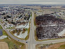
Minnesota State Highway 5 is a 76.347-mile-long (122.869 km) highway in Minnesota, which runs from its intersection with MN 19 and MN 22 in Gaylord and continues east and northeast to its eastern terminus at its intersection with MN 120 in Maplewood. The route passes through downtown Saint Paul.

Minnesota State Highway 77 (MN 77) is a 11.403-mile-long (18.351 km) highway in Minnesota, which runs from its intersection with 138th Street in Apple Valley and continues north to its northern terminus at its interchange with State Highway 62 in Minneapolis. MN 77 is also known as Cedar Avenue.

Minnesota State Highway 47 is a 126.872-mile-long (204.181 km) highway in east–central Minnesota, which runs from its intersection with Central Avenue in Minneapolis and continues north to its northern terminus at its intersection with U.S. Highway 169 in Aitkin.
Minnesota State Highway 16 is an 87.671-mile-long (141.093 km) two-lane highway in southeast Minnesota, which runs from its interchange with Interstate Highway 90 in Dexter and continues east to its eastern terminus at the Wisconsin state line concurrent with U.S. Highways 14 and 61 outside La Crescent just west of La Crosse, Wisconsin.

Minnesota State Highway 74 (MN 74) is a 34.956-mile-long (56.256 km) highway in southeast Minnesota that runs from its intersection with U.S. Highway 52 and State Highway 30 in Chatfield and continues north to its northern terminus at its intersection with U.S. Highway 61 at Weaver along the Mississippi River. It is the only remaining road in the state highway system that is still partially unpaved.
Minnesota State Highway 80 (MN 80) is a two-lane 8.431-mile-long (13.568 km) highway in southeast Minnesota that runs from its intersection with State Highway 16 near Wykoff and continues east to its eastern terminus at its intersection with U.S. Highway 52 at Fountain.

Minnesota State Highway 76 is a highway in southeast Minnesota, which runs from Iowa Highway 76 at the Iowa state line, and continues north to its northern terminus at its interchange with Interstate Highway 90 in Pleasant Hill Township near Winona.

Minnesota State Highway 56 (MN 56) is a 99.121-mile-long (159.520 km) highway in southeast Minnesota, which runs from its intersection with U.S. Highway 63 near the Iowa state line and Chester, Iowa, and continues north to its northern terminus at its junction with U.S. Highway 52 and State Highway 50 in Hampton.
Minnesota State Highway 22 (MN 22) is a 166.325-mile-long (267.674 km) highway in south-central and central Minnesota, which runs from Winnebago County Road R50 at the Iowa state line near Kiester and continues north to its northern terminus at its intersection with State Highway 23 in Richmond, west of St. Cloud.

Minnesota State Highway 19 is a 207.877-mile-long (334.546 km) highway in southern Minnesota, which runs from South Dakota Highway 30 at the South Dakota state line near Ivanhoe and continues east to its eastern terminus at its intersection with U.S. Highway 61 in Red Wing.
Minnesota State Highway 42 (MN 42) is a 30.717-mile-long (49.434 km) highway in southeast Minnesota, which runs from its interchange with Interstate 90 near Eyota and continues north and northeast to its northern terminus at its intersection with U.S. Highway 61 in Kellogg.

Minnesota State Highway 68 (MN 68) is a 141.026-mile-long (226.959 km) highway in southwest and south-central Minnesota, which runs from South Dakota Highway 22 at the South Dakota state line near Canby, and continues east to its eastern terminus at its intersection with U.S. Highway 169 and State Highway 60 in South Bend Township near Mankato.
Minnesota State Highway 92 (MN 92) is a 71.526-mile-long (115.110 km) highway in northwest Minnesota, which runs from its intersection with State Highway 32 in Lake Pleasant Township near Red Lake Falls and continues east and then south to its eastern terminus at its intersection with State Highway 200 at Zerkel, south of the city of Bagley.

Minnesota State Highway 104 is a 27.320-mile-long (43.967 km) highway in west-central Minnesota, which runs from its intersection with State Highway 9 in Norway Lake Township near Sunburg and continues north to its northern terminus at its intersection with State Highways 28 and 29 in the city of Glenwood.

Minnesota State Highway 106 is a 7.365-mile-long (11.853 km) highway in west-central Minnesota, which runs from its intersection with State Highway 29 in Deer Creek and continues north to its northern terminus at its intersection with U.S. Highway 10 near New York Mills.
Minnesota State Highway 86 (MN 86) is a highway in southwest Minnesota, which runs from Iowa Highway 86 at the Iowa state line, near Spirit Lake, IA, and continues north to its northern terminus at its intersection with State Highway 60 near Windom and Wilder.

Minnesota State Highway 89 (MN 89) is a 143.650-mile-long (231.182 km) highway in northwest Minnesota, which runs from its intersection with U.S. Highway 2 at Eckles Township, just north of Wilton and continues north to its northern terminus at the Canada–United States border, where it becomes Manitoba Highway 89, near Pinecreek.

Minnesota State Highway 117 is a short 1.797-mile-long (2.892 km) highway in west central Minnesota, which runs from Roberts County Road 19 at the South Dakota state line and continues east to its eastern terminus at its intersection with MN 27 near Wheaton. MN 117 passes through Lake Valley Township.

Minnesota State Highway 200 (MN 200) is a 201.203-mile-long (323.805 km) highway in northwest and northeast Minnesota, which runs from North Dakota Highway 200 at the North Dakota state line near Halstad, and continues east to its eastern terminus at its intersection with U.S. Highway 2 in Northeast Aitkin County, 9-miles west of Floodwood.

Minnesota State Highway 113 is a 54.592-mile-long (87.857 km) highway in northwest Minnesota, which runs from its intersection with State Highway 32 in Syre and continues east to its eastern terminus at its intersection with U.S. Highway 71 in Clover Township.


