Laura Elizabeth Ingalls Wilder was an American writer known for the Little House on the Prairie series of children's books, published between 1932 and 1943, which were based on her childhood in a settler and pioneer family.
The "Little House" Books is a series of American children's novels written by Laura Ingalls Wilder, based on her childhood and adolescence in the American Midwest between 1870 and 1894. Eight of the novels were completed by Wilder, and published by Harper & Brothers. The appellation "Little House" books comes from the first and third novels in the series of eight published in her lifetime. The second novel was about her husband's childhood. The first draft of a ninth novel was published posthumously in 1971 and is commonly included in the series.
Lake Benton is a city in Lincoln County, Minnesota, United States. The population was 683 at the 2010 census.
Rochester is a city founded in 1854 in the U.S. State of Minnesota and is the county seat of Olmsted County located on the Zumbro River's south fork in Southeast Minnesota. It is Minnesota's third-largest city and the largest city located outside the Minneapolis-St. Paul Metropolitan Statistical Area. As of 2015, the Rochester metropolitan area has a population of 215,884. According to the 2010 United States Census the city has a population of 106,769. The U.S. Census Bureau estimated that the 2017 population was 115,733. It is the home of the Mayo Clinic and an IBM facility, formerly one of the company's largest. The city has long been rated as one of the best places to live in the United States by multiple publications such as Money.
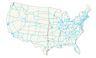
U.S. Route 63 is a highway in southeastern Minnesota that runs from the Minnesota-Iowa border south of Spring Valley to the Mississippi River at Red Wing. It connects the cities of Spring Valley, Stewartville, Rochester, and Lake City.
Lake City is a city in Goodhue and Wabasha counties in the U.S. state of Minnesota. It lies along Lake Pepin, a wide portion of the Mississippi River. The population was 5,063 at the 2010 census. Most of Lake City is located within Wabasha County with only a small portion in Goodhue County.
This page is based on this Wikipedia article Text is available under the CC BY-SA 4.0 license; additional terms may apply. Images, videos and audio are available under their respective licenses.
Related Research Articles
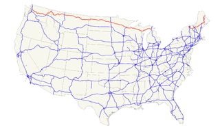
U.S. Route 12 is an east–west United States highway, running from Aberdeen, Washington, to Detroit, Michigan, for almost 2,500 miles (4,000 km). As a thoroughfare, it has mostly been supplanted by I-90 and I-94, but remains an important road for local and regional travel.
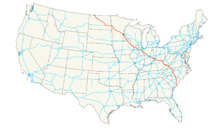
U.S. Route 61 (US 61) is the official designation for a major United States highway which extends 1,400 miles (2,300 km) between New Orleans, Louisiana and the city of Wyoming, Minnesota. The highway generally follows the course of the Mississippi River, and is designated the Great River Road for much of its route. As of 2004, the highway's northern terminus in Wyoming, Minnesota, is at an intersection with Interstate 35 (I-35). Until 1991, the highway extended north on what is now Minnesota State Highway 61 through Duluth and across the Canada–U.S. border, near Grand Portage. Its southern terminus in New Orleans, Louisiana, is at an intersection with Tulane Avenue at South Broad Street. The highway is often called the Blues Highway because it connects Saint Paul, Minnesota; St. Louis, Missouri; Memphis, Tennessee; the Mississippi Delta, and New Orleans.
U.S. Route 14, an east–west route, is one of the original United States highways of 1926. It currently has a length of 1,398 miles (2,250 km), but it had a peak length of 1,429 miles (2,300 km). For much of its length, it runs roughly parallel to Interstate 90.
U.S. Route 77 is a major north–south United States highway which extends for 1305 miles in the central United States. As of 2005, the highway's northern terminus is in Sioux City, Iowa, at an interchange with Interstate 29. Its southern terminus is in Brownsville, Texas, at Veteran's International Bridge on the U.S.-Mexico border, where it connects with both Mexican Federal Highway 101 and Mexican Federal Highway 180.
U.S. Route 2 or U.S. Highway 2 (US 2) is an east–west U.S. Highway spanning 2,571 miles (4,138 km) across the northern continental United States. US 2 consists of two segments connected by various roadways in southern Canada. Unlike some routes, which are disconnected into segments because of encroaching Interstate Highways, the two portions of US 2 were designed to be separate in the original 1926 highway plan.
U.S. Route 52 (US 52) is a major United States highway in the central United States that extends from the northern to southeastern region of the United States. Contrary to most other even-numbered U.S. Highways, US 52 primarily follows a northwest–southeast route, and is signed north–south or east–west depending on the local orientation of the route.
U.S. Route 16 (US 16) is an east–west United States Highway between Rapid City, South Dakota and Yellowstone National Park in Wyoming.
U.S. Route 18 is an east–west U.S. highway in the Midwestern United States. The western terminus is in Orin, Wyoming at an interchange with Interstate 25. Its eastern terminus is in downtown Milwaukee, Wisconsin. However, US 18 runs concurrent with other U.S. routes from its western terminus to Mule Creek Junction, Wyoming.
U.S. Highway 55 was a north–south United States highway. Though it was part of the original 1926 numbering plan, it was deleted within 10 years.
U.S. Highway 8 (US 8) is a United States Numbered Highway that runs primarily east–west for 280 miles (451 km), mostly within the state of Wisconsin. It connects Interstate 35 (I-35) in Forest Lake, Minnesota, to US 2 at Norway in the Upper Peninsula of Michigan near the border with Wisconsin. Except for the short freeway segment near Forest Lake, and sections near the St. Croix River bridge and Rhinelander, Wisconsin, it is mostly undivided surface road. As a state highway in the three states, US 8 is maintained by the Minnesota, Wisconsin and Michigan departments of transportation.
In the U.S. state of Minnesota, a legislative route is a highway number defined by the Minnesota State Legislature. The routes from 1 to 70 are constitutional routes, defined as part of the Babcock Amendment to the Minnesota State Constitution, passed November 2, 1920. All of them were listed in the constitution until a 1974 rewrite. Though they are now listed separately in §161.114 of the Minnesota Statutes, the definitions are legally considered to be part of the constitution, and cannot be altered or removed without an amendment. Legislative routes with numbers greater than 70 can be added or deleted by the legislature.
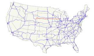
Iowa Highway 9 is the most northern of Iowa's east–west highways, traversing the entire northern tier of counties. It runs from the eastern terminus of South Dakota Highway 42 at the South Dakota border east of Sioux Falls, South Dakota near Benclare, to the Wisconsin border at Lansing where it continues as Wisconsin Highway 82. It is largely rural in character, bypassing any large city. Making a few dips north and south, the highway largely follows a very straight east–west alignment.
Iowa Highway 163 is a state highway that travels from U.S. Highway 69 in Des Moines to US 63 near Oskaloosa. The Iowa Department of Transportation has signed Iowa 163 from Oskaloosa to Burlington along US 63 and US 34, but it does not officially recognize those sections of road as part of the route.
Minnesota State Highway 56 (MN 56) is a highway in southeast Minnesota, which runs from its intersection with U.S. Highway 63 near the Iowa state line and Chester, Iowa, and continues north to its northern terminus at its junction with U.S. Highway 52 and State Highway 50 in Hampton.
Trunk Highway 60 (MN 60) is a highway in southern Minnesota, which runs from Iowa Highway 60 at the Iowa state line and continues east-northeast to its eastern terminus at the Wisconsin state line, where the route becomes Wisconsin Highway 25 upon crossing the Mississippi River.
U.S. Highway 52 enters the state of Minnesota at the unincorporated community of Prosper, north of the town of Burr Oak, Iowa. The route is marked north–south in Minnesota along its independent segment from the Iowa state line to downtown St. Paul. Highway 52 is not signed along the length of its concurrency with Interstate 94 (I-94) from downtown St. Paul to the North Dakota state line at Moorhead and Fargo.
U.S. Highway 18 (US 18) is the northernmost east–west U.S. Highway in the state of Iowa. As with all state highways in Iowa, it is maintained by the Iowa Department of Transportation (Iowa DOT). It enters the state by crossing the Big Sioux River between Inwood and Canton, South Dakota. It travels 311 miles (501 km) and connects Spencer, Mason City and Charles City. The highway leaves the state via the Marquette–Joliet Bridge over the Mississippi River at Marquette. Prior to becoming a U.S. Highway, the route US 18 follows was known as Primary Road No. 19 and the National Parks Pike.