
Elko Regional Airport – formerly Elko Municipal Airport – is a public airport located approximately 1 mile (1.6 km) west of downtown Elko, in Elko County, Nevada, United States.

Merrill Field is a public-use general aviation airport located one mile (1.6 km) east of downtown Anchorage in the U.S. state of Alaska. The airport is owned by Municipality of Anchorage. It opened in 1930 as Anchorage Aviation Field and was renamed in honor of Alaska aviation pioneer Russel Merrill.
Hutchinson Municipal Airport, also known as Butler Field, is a public airport located two miles (3 km) south of the central business district of Hutchinson, a city in McLeod County, Minnesota, United States. It is owned by the City of Hutchinson. The airport is home to the Civil Air Patrol. The FBO is operated by ASI JET.

Danbury Municipal Airport is a public use general aviation and commercial airport located three miles (5 km) southwest of the central business district of Danbury, in Fairfield County, Connecticut, United States. The airport opened in 1930. It is currently run by the City of Danbury under the management of Michael Safranek. It is included in the Federal Aviation Administration (FAA) National Plan of Integrated Airport Systems for 2017–2021, in which it is categorized as a regional reliever airport facility.
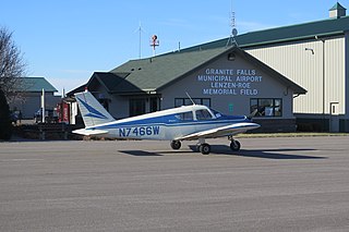
Granite Falls Municipal Airport, also known as Lenzen-Roe Memorial Field, is a public-use airport in Yellow Medicine County, Minnesota, United States. It is owned by the City of Granite Falls and located four nautical miles (7 km) south of its central business district. The airport is situated near State Highway 23.
Marina Municipal Airport is a public airport located two miles (3 km) east of the central business district of Marina, a city in Monterey County, California, United States. It is owned by the City of Marina.

Houston County Airport is a public use airport located three miles south of the central business district of Caledonia, a city in Houston County, Minnesota, United States. It is owned by Houston County. It serves general aviation for Caledonia and surrounding towns including Spring Grove and Houston. There is no scheduled air service. The airport opened in 1968. The dedication of the completed airport was held on September 21, 1969.
Longville Municipal Airport is a city-owned public-use airport located one nautical mile (1.85 km) northeast of the central business district of Longville, a city in Cass County, Minnesota, United States.
Maple Lake Municipal Airport is a city-owned, public-use airport located one nautical mile (2 km) northeast of the central business district of Maple Lake, a city in Wright County, Minnesota, United States. It is located on Maple Lake and is also known as Maple Lake Municipal Airport & Seaplane Base. The current full name is now Maple Lake Municipal - Bill Mavencamp Sr Field.
Aitkin Municipal Airport, also known as Steve Kurtz Field, is a public use airport located two nautical miles (4 km) northeast of the central business district of Aitkin, a city in Aitkin County, Minnesota, United States. It is owned by the County & City of Aitkin.
Litchfield Municipal Airport is a city-owned public-use airport located two nautical miles southeast of the central business district of Litchfield, a city in Meeker County, Minnesota, United States. The airport at this location opened in 1987. The original Litchfield Airport was closer to town and was located near the County Fair Grounds.
Indy South Greenwood Airport is a city-owned public-use airport in Greenwood, a city in Johnson County, Indiana, United States. It is 10 miles (16 km) southeast of Downtown Indianapolis. The airport was founded in September 1947 and is primarily used for general aviation. The airport has several on-field businesses, including a flight school and maintenance shop. In 2022 the airport was awarded Airport of the Year by Aviation Indiana.
Pittsfield Penstone Municipal Airport is a public-use civil airport in Pittsfield, Pike County, Illinois, United States. It is owned by the City of Pittsfield and is located between the Mississippi and Illinois Rivers. The airport is classified as a general aviation facility by the Federal Aviation Administration.
Blue Earth is a city-owned public-use airport located three miles south of the city of Blue Earth, Minnesota in Faribault County.
Paynesville Municipal Airport is a city-owned public-use airport located one mile southwest of the city of Paynesville, Minnesota in Stearns County.
Glencoe Municipal Airport also known as Vernon Perschau Field is a city-owned public-use airport located three miles south-east of the city of Glencoe, Minnesota in McLeod County.
Hawley Municipal Airport is a city-owned public-use airport located four miles south-east of the city of Hawley, Minnesota in Clay County.
Windom Municipal Airport is a city-owned public-use airport located three miles north of the city of Windom, Minnesota in Cottonwood County.
Redwood Falls Municipal Airport is a city-owned public-use airport located two miles north-east of the city of Redwood Falls, Minnesota in Redwood County.
Hallock Municipal Airport is a city-owned public-use airport located one mile south of the city of Hallock, Minnesota in Kittson County.


