
Range Regional Airport is a public use airport located four nautical miles southeast of the central business district of Hibbing, in Saint Louis County, Minnesota, United States. It was formerly known as Chisholm-Hibbing Airport or Chisholm-Hibbing Municipal Airport. The airport is mostly used for general aviation but is also served by one commercial and one charter airline. Scheduled passenger service is subsidized by the Essential Air Service program.
Clarion Municipal Airport is a city-owned public-use airport located one nautical mile (1.85 km) northwest of the central business district of Clarion, a city in Wright County, Iowa, United States. This airport is included in the FAA's National Plan of Integrated Airport Systems for 2009–2013, which categorized it as a general aviation facility.
Longville Municipal Airport is a city-owned public-use airport located one nautical mile (1.85 km) northeast of the central business district of Longville, a city in Cass County, Minnesota, United States.
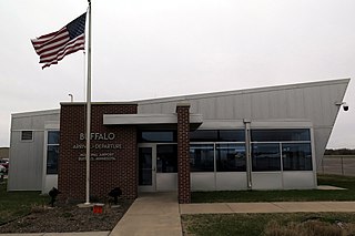
Buffalo Municipal Airport is a city-owned public-use airport located two miles (3 km) southeast of the central business district of Buffalo, a city in Wright County, Minnesota, United States.
Benson Municipal Airport Veteran's Field is a city-owned public-use airport located two miles (3 km) west of the central business district of Benson, a city in Swift County, Minnesota, United States.
Cambridge Municipal Airport is a city-owned public-use airport located two miles (3 km) southwest of the central business district of Cambridge, a city in Isanti County, Minnesota, United States.
Maple Lake Municipal Airport is a city-owned, public-use airport located one nautical mile (2 km) northeast of the central business district of Maple Lake, a city in Wright County, Minnesota, United States. It is located on Maple Lake and is also known as Maple Lake Municipal Airport & Seaplane Base. The current full name is now Maple Lake Municipal - Bill Mavencamp Sr Field.
Aitkin Municipal Airport, also known as Steve Kurtz Field, is a public use airport located two nautical miles (4 km) northeast of the central business district of Aitkin, a city in Aitkin County, Minnesota, United States. It is owned by the County & City of Aitkin.

Austin Municipal Airport is a public owned public use airport located two nautical miles (3.2 km) east of the central business district of the city of Austin, in Mower County, Minnesota, United States.
Fairmont Municipal Airport is a city-owned public-use airport located two nautical miles (3.7 km) southeast of the central business district of Fairmont, a city in Martin County, Minnesota, United States.
Litchfield Municipal Airport is a city-owned public-use airport located two nautical miles southeast of the central business district of Litchfield, a city in Meeker County, Minnesota, United States. The airport at this location opened in 1987. The original Litchfield Airport was closer to town and was located near the County Fair Grounds.

Princeton Municipal Airport is a city-owned public-use airport located one nautical mile southwest of the central business district of Princeton, a city in Mille Lacs County, Minnesota, United States. This airport is included in the FAA's National Plan of Integrated Airport Systems 2015–2019, which categorizes it as a general aviation airport.
Centerville Municipal Airport is a city-owned public-use airport located three nautical miles (6 km) southwest of the central business district of Centerville, a city in Appanoose County, Iowa, United States. According to the FAA's National Plan of Integrated Airport Systems for 2009–2013, it is categorized as a general aviation airport.
Orange City Municipal Airport was a city-owned public-use airport located one nautical mile (1.85 km) south of the central business district of Orange City, a city in Sioux County, Iowa, United States. This airport was included in the FAA's National Plan of Integrated Airport Systems for 2009–2013, which categorized it as a general aviation facility.
Wheaton Municipal Airport is a city-owned public-use airport located three miles southwest of the central business district of Wheaton, a city in Traverse County, Minnesota, United States.
Pipestone Municipal Airport is a city-owned public-use airport located one mile southeast of the central business district of Pipestone, a city in Pipestone County, Minnesota, United States.
Luverne Municipal Airport, also known as Quentin Aanenson Field, is a public use airport in Rock County, Minnesota, United States. It is owned by the City of Luverne and located two nautical miles (4 km) south of its central business district. This airport is included in the National Plan of Integrated Airport Systems for 2011–2015, which categorized it as a general aviation facility.
Jackson Municipal Airport is a city-owned public-use airport located two nautical miles north of the central business district of Jackson, a city in Jackson County, Minnesota, United States. It is included in the FAA's National Plan of Integrated Airport Systems for 2011–2015, which categorized it as a general aviation facility.
Tracy Municipal Airport is a city-owned public-use airport located one mile northeast of the central business district of Tracy, a city in Lyon County, Minnesota, United States.
Denison Municipal Airport is a city-owned, public-use airport located two nautical miles (4 km) southwest of the central business district of Denison, a city in Crawford County, Iowa, United States. It is included in the National Plan of Integrated Airport Systems for 2011–2015, which categorized it as a general aviation facility.

