Taunton Municipal Airport, also known as King Field, is a public use airport located three nautical miles (6 km) east of the central business district of Taunton, a city in Bristol County, Massachusetts. It is located in the East Taunton neighborhood of the city. The city-owned airport is maintained and operated by the Taunton Airport Commission. According to the FAA's National Plan of Integrated Airport Systems for 2009–2013, it is categorized as a general aviation airport.
Abrams Municipal Airport is a city-owned, public-use airport located two nautical miles (3.7 km) north of the central business district of Grand Ledge, a city in Eaton County, Michigan, United States. It is included in the Federal Aviation Administration (FAA) National Plan of Integrated Airport Systems for 2017–2021, in which it is categorized as a local general aviation facility.

Chicago/Aurora Municipal Airport is a public airport opened in April 1966, located in the village of Sugar Grove, Illinois, United States, 8 miles (13 km) west of the city of Aurora, both in Kane County. The airport is owned and operated by the City of Aurora. It is 50 miles (80 km) west of Chicago and is designated as a reliever airport for Chicago's O'Hare and Midway airports.
Waseca Municipal Airport is a public airport located two miles (3 km) west of the central business district of Waseca, in Waseca County, Minnesota, United States. It is owned by the City of Waseca.
Wadena Municipal Airport is a public airport located three miles (4.8 km) west of the central business district of Wadena, a city in Otter Tail County, Minnesota, United States. It is owned by the City of Wadena.
Little Falls/Morrison County Airport, also known as Lindbergh Field, is a public airport located two miles (3 km) south of the central business district of Little Falls, a city in Morrison County, Minnesota, United States. It is owned by the City of Little Falls and Morrison County.
Northeast Iowa Regional Airport is a public airport located three miles (5 km) east of the central business district of Charles City, in Floyd County, Iowa, United States. It is owned by the North Cedar Aviation Authority and was formerly known as Charles City Municipal Airport.
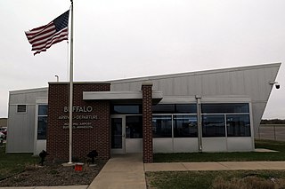
Buffalo Municipal Airport is a city-owned public-use airport located two miles (3 km) southeast of the central business district of Buffalo, a city in Wright County, Minnesota, United States.
Baudette International Airport is a county-owned public-use airport located one mile (2 km) north of the central business district of Baudette, a city in Lake of the Woods County, Minnesota, United States. Also known as Baudette International Airport & Seaplane Base, it is located on the Rainy River, which is the border between Minnesota in the U.S. and Ontario in Canada.
Aitkin Municipal Airport, also known as Steve Kurtz Field, is a public use airport located two nautical miles (4 km) northeast of the central business district of Aitkin, a city in Aitkin County, Minnesota, United States. It is owned by the County & City of Aitkin.

Crookston Municipal Airport, also known as Kirkwood Field, is a city-owned public-use airport located four nautical miles (7 km) north of the central business district of Crookston, a city in Polk County, Minnesota, United States.
Madison Municipal Airport is a city-owned public use airport located one nautical mile northeast of the central business district of Madison, a city in Lake County, South Dakota, United States. This airport is included in the FAA's National Plan of Integrated Airport Systems for 2009–2013, which categorized it as a general aviation facility.
Detroit Lakes Airport is a city-owned public-use airport located two miles (3 km) west of the central business district of Detroit Lakes, a city in Becker County, Minnesota, United States.
Moorhead Municipal Airport is a city-owned public-use airport located four miles south east of the central business district of Moorhead, a city in Clay County, Minnesota.
Wheaton Municipal Airport is a city-owned public-use airport located three miles southwest of the central business district of Wheaton, a city in Traverse County, Minnesota, United States.
Pipestone Municipal Airport is a city-owned public-use airport located one mile southeast of the central business district of Pipestone, a city in Pipestone County, Minnesota, United States.
Jackson Municipal Airport is a city-owned public-use airport located two nautical miles north of the central business district of Jackson, a city in Jackson County, Minnesota, United States. It is included in the FAA's National Plan of Integrated Airport Systems for 2011–2015, which categorized it as a general aviation facility.
Perham Municipal Airport is a city-owned public-use airport located two miles northwest of the central business district of Perham, a city in Otter Tail County, Minnesota, United States.
Warren Municipal Airport is a city-owned, public-use airport located two nautical miles (4 km) east of the central business district of Warren, a city in Marshall County, Minnesota, United States.
Creston Municipal Airport is a city-owned public-use airport located three nautical miles (6 km) south of the central business district of Creston, a city in Union County, Iowa, United States. It is included in the National Plan of Integrated Airport Systems for 2011–2015, which categorized it as a general aviation facility.

