
Watertown Regional Airport, formerly Watertown Municipal Airport, is two miles northwest of Watertown in Codington County, South Dakota, United States.

Pierre Regional Airport is a public airport three miles east of Pierre, in Hughes County, South Dakota.

Huron Regional Airport is in Huron, in Beadle County, South Dakota. The airport has charter passenger flights operated by fixed base operator (FBO), Fly Jet Center and Revv Aviation. Revv Aviation wants to bring all services to Huron including maintenance, avionics, flight school and charter.

Aberdeen Regional Airport is a city-owned, public-use airport located two nautical miles east of the central business district of Aberdeen, a city in Brown County, South Dakota, United States. It is mostly used for general aviation, and is served by Delta Connection.

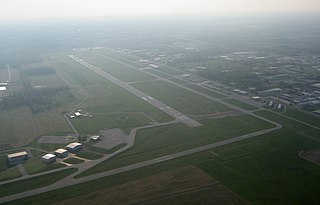
Glacier Park International Airport is in Flathead County, Montana, United States, six miles northeast of Kalispell. The airport is owned and operated by the Flathead Municipal Airport Authority, a public agency created by the county in 1974.
Tunica Municipal Airport is a public use airport located one nautical mile (2 km) east of the central business district of Tunica, in Tunica County, Mississippi, United States. It is owned by the Tunica County Airport Commission. Also known as Tunica Airport, it should not be confused with the 10 acre privately owned, public use Tunica Airport located 2 nautical miles (4 km) south of the center of town, which has been recently changed to Ralph M Sharpe Airport.
Chan Gurney Municipal Airport is a regional airport located three miles north of Yankton, in Yankton County, South Dakota.

Winona Municipal Airport is located three miles northwest of Winona, Minnesota and next to Goodview on the Mississippi River, in Winona County, Minnesota. It has no scheduled airline flights.
South St. Paul Municipal Airport, also known as Richard E. Fleming Field or simply Fleming Field, is a city-owned public-use airport located two miles (3 km) south of the central business district of South St. Paul, a city in Dakota County, Minnesota, United States. It is named for Richard E. Fleming, a United States Marine Corps Naval Aviator during World War II who was posthumously awarded a Medal of Honor. It is the only reliever airport for Minneapolis–St. Paul International Airport that is not operated by the Metropolitan Airports Commission.
Southwest Minnesota Regional Airport or Marshall/Ryan Field is a general aviation airport located 1 mile west of the central business district (CBD) of Marshall, Minnesota, United States. It is primarily a general aviation facility, though passenger air service did once exist on Midwest Aviation, also known as Lake State Airways. The namesake for Ryan Field is Matthew Ryan, commissioner of small airport around Minneapolis.
New Ulm Municipal Airport is a public airport located two statute miles (3 km) west of the central business district (CBD) of New Ulm, a city in Brown County, Minnesota, United States. This general aviation airport covers 195 acres (79 ha) and has two runways. Operational since September 1945, scheduled airline service was once available on Midwest Aviation, also known as Lake State Airways, though today only charter flights are offered by the city's New Ulm Flight Service, founded in the 1960s.
Mankato Regional Airport is a public airport located five miles (8 km) northeast of the central business district of Mankato, a city in Blue Earth County, Minnesota, United States. This airport is publicly owned by the city of Mankato. The airport is home to Northstar Aviation (FBO) and Minnesota State University's flight training program. Base to Mn composite Squadron Mn 048 Civil Air Patrol (CAP/USAF-AUX)
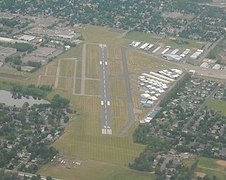
Elkhart Municipal Airport is a city-owned public-use airport located three nautical miles (6 km) northwest of the central business district of Elkhart, a city in Elkhart County, Indiana, United States.
Ely Municipal Airport is a public airport located in Saint Louis County, Minnesota, United States, four miles south of the city of Ely, which owns the airport.
Fairmont Municipal Airport is a city-owned public-use airport located two nautical miles (3.7 km) southeast of the central business district of Fairmont, a city in Martin County, Minnesota, United States.
Natchez–Adams County Airport, also known as Hardy–Anders Field, is a county-owned public-use airport located six nautical miles (11 km) northeast of the central business district of Natchez, a city in Adams County, Mississippi, United States.
Alexandria Municipal Airport, also known as Chandler Field, is a city-owned public-use airport located two nautical miles (3.7 km) southwest of the central business district of Alexandria, a city in Douglas County, Minnesota, United States.
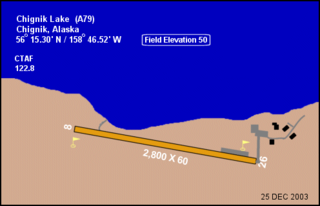
Chignik Lake Airport is a state-owned, public-use airport located at Chignik Lake, in the Lake and Peninsula Borough of the U.S. state of Alaska.
Chignik Lagoon Airport is a state-owned, public-use airport serving Chignik Lagoon, in the Lake and Peninsula Borough of the U.S. state of Alaska. It is also known as Chignik Flats Airport. Scheduled airline service to King Salmon Airport is provided by Grant Aviation.
Appleton Municipal Airport, is a public use airport located 2 miles (3 km) northeast of the central business district of Appleton, a city in Swift County, Minnesota, United States. The closest airport with commercial airline service is Watertown Regional Airport about 60 miles (97 km) to the southwest.


