
Sierra Vista Municipal Airport, a joint-use civil-military airport which shares facilities with Libby Army Airfield, is located on Fort Huachuca in Sierra Vista, a city and U.S. Army installation in Cochise County, Arizona, United States. The airport has three runways and one helipad. It is mostly used for military aviation for the surrounding military base.

Watertown Municipal Airport is a public use airport located in and owned by the city of Watertown, in Jefferson County, Wisconsin, United States. It is included in the Federal Aviation Administration (FAA) National Plan of Integrated Airport Systems for 2021–2025, in which it is categorized as a regional general aviation facility.
Longville Municipal Airport is a city-owned public-use airport located one nautical mile (1.85 km) northeast of the central business district of Longville, a city in Cass County, Minnesota, United States.

Chicago/Aurora Municipal Airport is a public airport opened in April 1966, located in the village of Sugar Grove, Illinois, United States, 8 miles (13 km) west of the city of Aurora, both in Kane County. The airport is owned and operated by the City of Aurora. It is 50 miles (80 km) west of Chicago and is designated as a reliever airport for Chicago's O'Hare and Midway airports.
Little Falls/Morrison County Airport, also known as Lindbergh Field, is a public airport located two miles (3 km) south of the central business district of Little Falls, a city in Morrison County, Minnesota, United States. It is owned by the City of Little Falls and Morrison County.
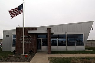
Buffalo Municipal Airport is a city-owned public-use airport located two miles (3 km) southeast of the central business district of Buffalo, a city in Wright County, Minnesota, United States.
Benson Municipal Airport Veteran's Field is a city-owned public-use airport located two miles (3 km) west of the central business district of Benson, a city in Swift County, Minnesota, United States.
Cambridge Municipal Airport is a city-owned public-use airport located two miles (3 km) southwest of the central business district of Cambridge, a city in Isanti County, Minnesota, United States.
Maple Lake Municipal Airport is a city-owned, public-use airport located one nautical mile (2 km) northeast of the central business district of Maple Lake, a city in Wright County, Minnesota, United States. It is located on Maple Lake and is also known as Maple Lake Municipal Airport & Seaplane Base. The current full name is now Maple Lake Municipal - Bill Mavencamp Sr Field.
Aitkin Municipal Airport, also known as Steve Kurtz Field, is a public use airport located two nautical miles (4 km) northeast of the central business district of Aitkin, a city in Aitkin County, Minnesota, United States. It is owned by the County & City of Aitkin.
Bay City Municipal Airport is a city-owned public-use airport located five nautical miles (9 km) east of the central business district of Bay City, in Matagorda County, Texas, United States.
Fairmont Municipal Airport is a city-owned public-use airport located two nautical miles (3.7 km) southeast of the central business district of Fairmont, a city in Martin County, Minnesota, United States.

Princeton Municipal Airport is a city-owned public-use airport located one nautical mile southwest of the central business district of Princeton, a city in Mille Lacs County, Minnesota, United States. This airport is included in the FAA's National Plan of Integrated Airport Systems 2015–2019, which categorizes it as a general aviation airport.
Detroit Lakes Airport is a city-owned public-use airport located two miles (3 km) west of the central business district of Detroit Lakes, a city in Becker County, Minnesota, United States.
Moorhead Municipal Airport is a city-owned public-use airport located four miles south east of the central business district of Moorhead, a city in Clay County, Minnesota.
Pipestone Municipal Airport is a city-owned public-use airport located one mile southeast of the central business district of Pipestone, a city in Pipestone County, Minnesota, United States.
Menomonie Municipal Airport is a city-owned public use airport located three miles east of the central business district of Menomonie, a city in Dunn County, Wisconsin, United States. It is included in the Federal Aviation Administration (FAA) National Plan of Integrated Airport Systems for 2021–2025, in which it is categorized as a local general aviation facility.
Jackson Municipal Airport is a city-owned public-use airport located two nautical miles north of the central business district of Jackson, a city in Jackson County, Minnesota, United States. It is included in the FAA's National Plan of Integrated Airport Systems for 2011–2015, which categorized it as a general aviation facility.
Tracy Municipal Airport is a city-owned public-use airport located one mile northeast of the central business district of Tracy, a city in Lyon County, Minnesota, United States.
Appleton Municipal Airport, is a public use airport located 2 miles (3 km) northeast of the central business district of Appleton, a city in Swift County, Minnesota, United States. The closest airport with commercial airline service is Watertown Regional Airport about 60 miles (97 km) to the southwest.

