Hayfield Township, Dodge County, Minnesota

Last updated

Hayfield Township, Minnesota
USA Minnesota location map.svg
Red pog.svg
Hayfield Township, Minnesota
Location within the state of Minnesota
Usa edcp location map.svg
Red pog.svg
Hayfield Township, Minnesota
Hayfield Township, Minnesota (the United States)
Coordinates: 43°52′47″N92°51′15″W / 43.87972°N 92.85417°W / 43.87972; -92.85417
Country United States
State Minnesota
County Dodge
Area
  Total36.6 sq mi (94.7 km2)
  Land36.6 sq mi (94.7 km2)
  Water0.0 sq mi (0.0 km2)
Elevation
1,302 ft (397 m)
Population
 (2000)
  Total445
  Density12.2/sq mi (4.7/km2)
Time zone UTC-6 (Central (CST))
  Summer (DST) UTC-5 (CDT)
ZIP code
55940
Area code 507
FIPS code 27-27890 [1]
GNIS feature ID0664425 [2]

Hayfield Township is a township in Dodge County, Minnesota, United States. The population was 445 at the 2000 census.

Contents

Hayfield Township was organized in 1872, and named after Hayfield Township, Crawford County, Pennsylvania. [3]

Geography

According to the United States Census Bureau, the township has a total area of 36.6 square miles (95 km2), all land.

Demographics

As of the census [1] of 2000, there were 445 people, 137 households, and 117 families residing in the township. The population density was 12.2 people per square mile (4.7/km2). There were 140 housing units at an average density of 3.8/sq mi (1.5/km2). The racial makeup of the township was 98.43% White, 0.45% Asian, 0.45% from other races, and 0.67% from two or more races. Hispanic or Latino of any race were 1.35% of the population.

There were 137 households, out of which 48.2% had children under the age of 18 living with them, 76.6% were married couples living together, 8.0% had a female householder with no husband present, and 13.9% were non-families. 11.7% of all households were made up of individuals, and 7.3% had someone living alone who was 65 years of age or older. The average household size was 3.25 and the average family size was 3.54.

In the township the population was spread out, with 36.4% under the age of 18, 5.4% from 18 to 24, 28.8% from 25 to 44, 18.0% from 45 to 64, and 11.5% who were 65 years of age or older. The median age was 35 years. For every 100 females, there were 107.0 males. For every 100 females age 18 and over, there were 96.5 males.

The median income for a household in the township was $48,438, and the median income for a family was $50,208. Males had a median income of $38,036 versus $25,313 for females. The per capita income for the township was $15,587. About 8.5% of families and 9.2% of the population were below the poverty line, including 14.4% of those under age 18 and 4.2% of those age 65 or over.

Related Research Articles

Center Township is a township in Crow Wing County, Minnesota, United States. The population was 808 at the 2000 census.

<span class="mw-page-title-main">Hayfield, Minnesota</span> City in Minnesota, United States

Hayfield is a city in Dodge County, Minnesota, United States. The population was 1,340 at the 2010 census.

Arendahl Township is a township in Fillmore County, Minnesota, United States. The population was 333 at the 2000 census.

Wildwood Township is a township in Itasca County, Minnesota, United States. The population was 193 at the 2010 census.

Norway Lake Township is a township in Kandiyohi County, Minnesota, United States. The population was 284 at the 2000 census.

Perry Township is a township in Lac qui Parle County, Minnesota, United States. The population was 137 at the 2000 census.

Donnelly Township is a township in Marshall County, Minnesota, United States. The population was 28 at the 2000 census.

Espelie Township is a township in Marshall County, Minnesota, United States. The population was 58 at the 2000 census.

Parker Township is a township in Marshall County, Minnesota, United States. The population was 57 at the 2000 census. Parker Township was organized in 1884, and named for George L. Parker, an early settler who had come to the area from Norridgewock, Maine.

Glencoe Township is a township in McLeod County, Minnesota, United States. The population was 565 at the 2000 census.

Harvey Township is a township in Meeker County, Minnesota, United States. The population was 445 at the 2000 census.

Racine Township is a township in Mower County, Minnesota, United States. The population was 445 at the time of the 2000 census. The largest town in the township is Racine with a population of 442 as of the 2010 census.. All other area in the township is unincorporated.

Wilma Township is a township in Pine County, Minnesota, United States. The population was 137 at the 2000 census.

Cotton Township is a township in Saint Louis County, Minnesota, United States. The population was 445 at the 2010 census.

Portage Township is a township in Saint Louis County, Minnesota, United States. The population was 170 at the 2010 census.

Grove Township is a township in Stearns County, Minnesota, United States. The population was 493 at the 2010 census. The township includes the southern one-third of the City of Melrose and the City of Greenwald.

Wilton Township is a township in Waseca County, Minnesota, United States. The population was 392 at the 2000 census.

<span class="mw-page-title-main">Madelia Township, Watonwan County, Minnesota</span> Township in Minnesota, United States

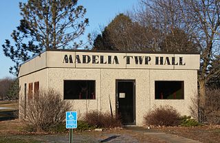
Madelia Township is a township in Watonwan County, Minnesota, United States. The population was 393 at the 2000 census.

Woodland Township is a township in Wright County, Minnesota, United States. The population was 1,137 at the 2000 census.

Lisbon Township is a township in Yellow Medicine County, Minnesota, United States. The population was 217 at the 2000 census.

References

  1. 1 2 "U.S. Census website". United States Census Bureau . Retrieved January 31, 2008.
  2. "US Board on Geographic Names". United States Geological Survey. October 25, 2007. Retrieved January 31, 2008.
  3. Upham, Warren (1920). Minnesota Geographic Names: Their Origin and Historic Significance. Minnesota Historical Society. p.  173.