
Steele County is a county in the U.S. state of Minnesota. As of the 2010 United States Census, the population was 36,576. Its county seat is Owatonna.
Dodge County is a county in the U.S. state of Minnesota. The population was 20,087 as of the 2010 United States Census. Its county seat is Mantorville.

Kasson is a city in Dodge County, Minnesota, United States. The population was 5,931 at the 2010 census. The city is located 13 miles (21 km) west of Rochester, Minnesota along U.S. Highway 14 and is one of the endpoints of Minnesota State Highway 57. The Dakota, Minnesota and Eastern Railroad's main freight rail line also runs through the city. Kasson shares a school system with nearby Mantorville, Minnesota. The K–M school system is a member of the Zumbro Education school district (ZED). Kasson is part of the Rochester, MN Metropolitan Statistical Area.

Wasioja Township is a township in Dodge County, Minnesota, United States. The population was 963 at the 2000 census. The unincorporated community of Wasioja is located within the township.

Rochester is a city founded in 1854 in the U.S. state of Minnesota and is the county seat of Olmsted County located on the Zumbro River's south fork in Southeast Minnesota. It is Minnesota's third-largest city and the largest city located outside the Minneapolis-St. Paul-Bloomington Metropolitan Statistical Area. As of 2018, the Rochester metropolitan area had a population estimated at 219,802. According to the 2010 United States Census the city had a population of 106,769. The U.S. Census Bureau estimated that the 2019 population was 118,935. It is the home of the Mayo Clinic and a major IBM facility, one of the company's largest at its peak.

Mazeppa is a city in Wabasha County, Minnesota, United States, along the North Fork of the Zumbro River. The population was 842 at the 2010 census.
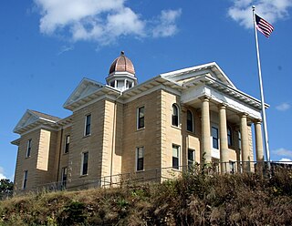
Mantorville is a city in Dodge County, Minnesota, United States. The population was 1,197 at the 2010 census. It is the county seat of Dodge County. Founded in 1854, the city is one of the oldest in Minnesota.

The Zumbro River is a tributary of the Mississippi River in the Driftless Area of southeastern Minnesota in the United States. It is 64.6 miles (104.0 km) long from the confluence of its principal tributaries and drains a watershed of 1,428 square miles (3,700 km2). The river's name in English is a change from its French name Rivière des Embarras due to its mouth near Pine Island in the Mississippi River; the pronunciation changed from [dez‿ɑ̃.ba.ʁɑ] to. The Dakota name for this river is Wapka Wazi Oju, having reference to the grove of great white pines at Pine Island.

West Albany is an unincorporated community in West Albany Township, Wabasha County, Minnesota, United States.
Inger is an unincorporated community and census-designated place (CDP) in Itasca County, Minnesota, United States, along the Bowstring River of the Leech Lake Indian Reservation. As of the 2010 census, its population was 212.

The United States Census Bureau defines the Rochester, Minnesota Metropolitan Statistical Area (MSA) as an area consisting of four counties in southeast Minnesota, anchored by the city of Rochester. As of 2018, the US Census Bureau estimates that the Rochester metropolitan statistical area has a population of 219,802. The Rochester–Austin combined statistical area has a population of 259,813 as of 2018.

Reads Landing is an unincorporated community in Pepin Township, Wabasha County, Minnesota, United States, along the Mississippi River.
Berne is an unincorporated community in Milton Township, Dodge County, Minnesota, United States. The community is located near the junction of State Highway 57 and Dodge County Road 24. The Middle Fork of the Zumbro River flows nearby.
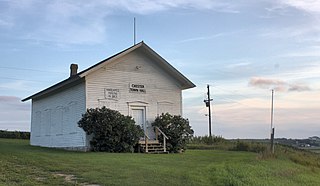
The Bear Valley Grange Hall is a historic meeting hall in Chester Township, Minnesota, United States. It was built in 1874 for the exclusive use of a local chapter of the National Grange of the Order of Patrons of Husbandry, an early farmers' advocacy group and fraternal organization. The chapter folded in the 1880s and the building has been used since as the Chester Town Hall. It was listed on the National Register of Historic Places in 1989 for having local significance in the theme of social history. It was nominated for being the only surviving Grange hall in Wabasha County—and one of only a few in Minnesota—and a rare example of a purpose-built Grange hall, as most chapters met in existing spaces like schools.

Dresbach is an unincorporated community in Dresbach Township, Winona County, Minnesota, United States.
Oak Center is an unincorporated community in Gillford Township, Wabasha County, Minnesota, United States.
Theilman is an unincorporated community in Wabasha County, Minnesota, United States.
Oslo is an unincorporated community in Vernon Township, Dodge County, Minnesota, United States, near Hayfield. The community is located near the junction of State Highway 30 and Dodge County Road 13. The South Fork of the Zumbro River flows nearby.
Eden is an unincorporated community in Wasioja Township, Dodge County, Minnesota, United States. The community is located along Dodge County Road 16 near its junction with State Highway 56 and Dodge County Road G. Nearby places include Dodge Center, Wasioja, and West Concord. The South Branch Middle Fork of the Zumbro River flows nearby.
Concord is an unincorporated community in Concord Township, Dodge County, Minnesota, United States. The community is located near the junction of Dodge County Road 24 and 201st Avenue. County Roads 9 and 22 are also in the immediate area. The Middle Fork of the Zumbro River flows through the community. Nearby places include West Concord, Berne, and Wasioja.


