Fountain, Minnesota

Last updated
Fountain
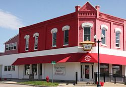
VillageSquareFountainMN.jpg
Village Square at First and Main Streets
Fillmore County Minnesota Incorporated and Unincorporated areas Fountain Highlighted.svg
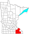
Location of Fountain, Minnesota
Coordinates: 43°44′29″N92°8′8″W / 43.74139°N 92.13556°W / 43.74139; -92.13556
Country United States
State Minnesota
County Fillmore
Area
[1]
  Total0.99 sq mi (2.57 km2)
  Land0.99 sq mi (2.57 km2)
  Water0.00 sq mi (0.00 km2)
Elevation
1,306 ft (398 m)
Population
 (2020)
  Total409
  Density411.47/sq mi (158.88/km2)
Time zone UTC-6 (Central (CST))
  Summer (DST) UTC-5 (CDT)
ZIP code
55935
Area code 507
FIPS code 27-22094 [2]
GNIS feature ID0643839 [3]

Fountain is a city in Fillmore County, Minnesota, United States. The population was 410 at the 2010 census. [4] Fountain is the western terminus of the Root River segment of the Root River State Trail. Local attractions include the Fillmore County History Center.

Contents

Geography

According to the United States Census Bureau, the city has a total area of 0.83 square miles (2.15 km2), all land. [5]

Fountain is claimed as the sinkhole capital of the United States of America [6] due to the prevalence of karst topography.

Demographics

Historical population
CensusPop.
1880 266
1890 248−6.8%
1900 29418.5%
1910 3219.2%
1920 3405.9%
1930 303−10.9%
1940 3061.0%
1950 3122.0%
1960 297−4.8%
1970 34716.8%
1980 327−5.8%
1990 3270.0%
2000 3434.9%
2010 41019.5%
2020 409−0.2%
U.S. Decennial Census [7]

2010 census

As of the census [8] of 2010, there were 410 people, 171 households, and 112 families living in the city. The population density was 494.0 inhabitants per square mile (190.7/km2). There were 177 housing units at an average density of 213.3 per square mile (82.4/km2). The racial makeup of the city was 98.0% White, 0.2% Native American, 0.5% Asian, 0.7% from other races, and 0.5% from two or more races. Hispanic or Latino of any race were 2.0% of the population.

There were 171 households, of which 35.7% had children under the age of 18 living with them, 52.6% were married couples living together, 7.0% had a female householder with no husband present, 5.8% had a male householder with no wife present, and 34.5% were non-families. 29.2% of all households were made up of individuals, and 10.5% had someone living alone who was 65 years of age or older. The average household size was 2.40 and the average family size was 2.96.

The median age in the city was 37.3 years. 27.1% of residents were under the age of 18; 5.8% were between the ages of 18 and 24; 25.9% were from 25 to 44; 27.1% were from 45 to 64; and 14.1% were 65 years of age or older. The gender makeup of the city was 50.7% male and 49.3% female.

2000 census

As of the census [2] of 2000, there were 343 people, 131 households, and 94 families living in the city. The population density was 413.4 inhabitants per square mile (159.6/km2). There were 137 housing units at an average density of 165.1 per square mile (63.7/km2). The racial makeup of the city was 98.54% White, 0.58% Native American, and 0.87% from two or more races.

There were 131 households, out of which 32.1% had children under the age of 18 living with them, 67.9% were married couples living together, 2.3% had a female householder with no husband present, and 27.5% were non-families. 20.6% of all households were made up of individuals, and 9.2% had someone living alone who was 65 years of age or older. The average household size was 2.62 and the average family size was 3.06.

In the city, the population was spread out, with 26.2% under the age of 18, 11.4% from 18 to 24, 30.3% from 25 to 44, 18.4% from 45 to 64, and 13.7% who were 65 years of age or older. The median age was 35 years. For every 100 females, there were 100.6 males. For every 100 females age 18 and over, there were 105.7 males.

The median income for a household in the city was $40,250, and the median income for a family was $49,583. Males had a median income of $28,571 versus $22,321 for females. The per capita income for the city was $18,085. None of the families and 3.4% of the population were living below the poverty line, including no under eighteens and 8.9% of those over 64.
Related Research Articles

<span class="mw-page-title-main">South Pasadena, Florida</span> City in Florida, United States

South Pasadena is a city in southern Pinellas County, Florida, United States, near St. Pete Beach. The population was 4,964 at the 2010 census.

<span class="mw-page-title-main">Maunaloa, Hawaii</span> Census-designated place in Hawaii, United States

Maunaloa or Mauna Loa is a census-designated place (CDP) in Maui County, Hawaiʻi, United States, in the western part of the island of Molokai. The population was 435 at the 2020 census.

<span class="mw-page-title-main">Cannelton, Indiana</span> City in Indiana, United States

Cannelton is a city in Troy Township, Perry County, in the U.S. state of Indiana, along the Ohio River. The population was 1,563 at the 2010 census. Cannelton, which was the smallest incorporated city in the state until 2010, was formerly the county seat of Perry County until the seat was relocated to Tell City.

<span class="mw-page-title-main">Fountain City, Indiana</span> Town in Indiana, United States

Fountain City, formerly Newport, is a town in New Garden Township, Wayne County, in the U.S. state of Indiana. The population was 796 at the 2010 census.

<span class="mw-page-title-main">Squaw Lake, Minnesota</span> City in Minnesota, United States

Squaw Lake is a city in Itasca County, Minnesota, United States. The population was 107 at the 2010 census.

<span class="mw-page-title-main">Henning, Minnesota</span> City in Minnesota, United States

Henning is a city in Otter Tail County, Minnesota, United States. The population was 854 at the 2020 census.

<span class="mw-page-title-main">Fountain N' Lakes, Missouri</span> Village in Missouri, United States

Fountain N' Lakes is a village in Lincoln County, Missouri, United States. The population was 165 at the 2010 census.

<span class="mw-page-title-main">Winfield, Missouri</span> City in Missouri, United States

Winfield is a city in Lincoln County, Missouri, United States. The population was 1,404 at the 2010 census.

Hume is a town in Allegany County, New York, United States. The population was 2,094 at the 2020 census. The town is on the northern border of Allegany County.

<span class="mw-page-title-main">Unionville Center, Ohio</span> Village in Ohio, United States

Unionville Center is a village in Union County, Ohio, in the United States. The population was 233 at the 2010 census.

<span class="mw-page-title-main">Springer, Oklahoma</span> Town in Oklahoma, United States

Springer is a town in Carter County, Oklahoma, United States. The population was 700 at the 2010 census. It is part of the Ardmore, Oklahoma Micropolitan Statistical Area.

<span class="mw-page-title-main">Butler Township, Schuylkill County, Pennsylvania</span> Township in Pennsylvania, United States

Butler Township is a township in Schuylkill County, Pennsylvania, United States. Formed in 1848 from part of Barry Township, it is named for war hero William Orlando Butler.

Fountain Springs is a census-designated place in Butler Township, Schuylkill County, Pennsylvania, United States. The population was 100 at the 2000 census.

<span class="mw-page-title-main">Hegins Township, Schuylkill County, Pennsylvania</span> Township in Pennsylvania, United States

Hegins Township is a township in Schuylkill County, Pennsylvania, United States. The population was 3,350 at the 2020 census.

<span class="mw-page-title-main">Lakesite, Tennessee</span> City in Tennessee, United States

Lakesite is a city in Hamilton County, Tennessee, United States. The population was 1,856 at the 2020 census. It is a northern suburb of the Chattanooga, TN–GA Metropolitan Statistical Area, located 15 miles north of the city.

<span class="mw-page-title-main">Rancho Alegre, Texas</span> Census-designated place in Texas, United States

Rancho Alegre is an unincorporated area and census-designated place (CDP) in Jim Wells County, Texas, United States. The population was 1,704 at the 2010 census.

<span class="mw-page-title-main">Cochrane, Wisconsin</span> Village in Wisconsin, United States

Cochrane is a village in Buffalo County in the U.S. state of Wisconsin. The population was 450 at the 2010 census.

<span class="mw-page-title-main">Templeville, Maryland</span> Town in Maryland, United States

Templeville is a town in Caroline and Queen Anne's counties, Maryland, United States. Templeville is located near the Maryland-Delaware line. The population was 138 at the 2010 census. It was known as Bullock Town until the name was changed in 1847. The name Templeville derives from the Temple family, whose most famous member was Governor William Temple of Delaware.

<span class="mw-page-title-main">Boscobel, Wisconsin</span> City in Wisconsin, United States

Boscobel is a city in Grant County, Wisconsin, United States. The population was 3,286 at the 2020 census. Approximately 0.6 mi. (1 km) to the north of the city, across a riparian swamp, is the Wisconsin River. U.S. Route 61 crosses the Wisconsin River at Boscobel. To the south, the city is bordered by the Town of Boscobel.

<span class="mw-page-title-main">Omro, Wisconsin</span> City in Wisconsin, United States

Omro is a city in Winnebago County, Wisconsin, United States. The population was 3,517 at the 2010 census. The city is located along the Fox River, approximately 10 miles west of Oshkosh, Wisconsin.

References

  1. "2020 U.S. Gazetteer Files". United States Census Bureau. Retrieved July 24, 2022.
  2. 1 2 "U.S. Census website". United States Census Bureau . Retrieved 2008-01-31.
  3. "US Board on Geographic Names". United States Geological Survey. 2007-10-25. Retrieved 2008-01-31.
  4. "2010 Census Redistricting Data (Public Law 94-171) Summary File". American FactFinder. United States Census Bureau . Retrieved 27 April 2011.[ dead link ]
  5. "US Gazetteer files 2010". United States Census Bureau. Archived from the original on 2012-07-02. Retrieved 2012-11-13.
  6. KARE 11: Land of 10,000 Capitals
  7. "Census of Population and Housing". Census.gov. Retrieved June 4, 2015.
  8. "U.S. Census website". United States Census Bureau . Retrieved 2012-11-13.

Coordinates: 43°44′24″N92°08′11″W / 43.74000°N 92.13639°W / 43.74000; -92.13639