The city is surrounded by the town of Olean and is located in the southeastern part of Cattaraugus County.
History
The first European in the area was possibly Joseph de La Roche Daillon, a missionary and explorer from Canada. La Roche reported on the presence of oil near Cuba, the first petroleum sighting in North America. At that time the area was a part of the territory of the Wenrohronon or Wenro Indians, an Iroquois speaking people. In 1643, the Wenro tribes became the first victims of a series of brutal conflicts known as the Second Beaver War.
The area was first settled by Europeans around 1765, called by the Indian name "Ischua". Officially, this was illegal, as the British had declared the land in the Allegheny River watershed to be part of the Indian Reserve after conquering the territory in the French and Indian War two years prior. The surface is a hilly upland, separated into two distinct parts by the valley of the Allegheny. The highest points are 500 to 600 feet (150 to 180m) above the valley. During the American Revolutionary War, the 1779 Sullivan Expedition established the first road to what would become Olean, blazing a trail to what is now Kittanning, Pennsylvania along the path of what is now New York State Route 16.
Originally the entire territory of the county of Cattaraugus was called the Town of Olean, formed March 11, 1808. As population allowed, the county was split in half and the top half was called "Hebe", and was taken off in 1812, a part of Perrysburgh in 1814, then Great Valley in 1818. Hinsdale formed in 1820, and Portville in 1837, leaving the current boundary of Olean that lies upon the south line of the county, near the southeast corner. The area remained sparsely populated until 1804, when Major Adam Hoops acquired the land and gave it its modern name. Hoops was a surveyor and Revolutionary War veteran, and was politically connected with Robert Morris, the financier of the Revolution. Along with Morris, Hoops became involved with the Holland Land Company, which was settling western New York.
This was a time of great western expansion into places such as Ohio and Indiana. Since neither canals nor railroads had become widespread by this point, the main means of travel was either by cart or small-boat travel. The Allegheny River was a major transportation route. Hoops believed that a great city could be created at the confluence of the Allegheny and one of its tributaries and went looking for the right spot. In 1804 he found a spot where Olean Creek meets the river; the confluence was important as it was the farthest point downstream in the state before hitting the Seneca Reservation that surrounded most of New York's piece of the river. Hoops received title to 20,000 acres (81km2) from the Holland Land Company in 1804. Hoops' brother Robert came to the site and built the first permanent structure near today's Forness Park, calling the area Hamilton in honor of Alexander Hamilton.
In a letter to Joseph Ellicott in 1804, Hoops discusses the name Olean from the local Oil Springs and the Latin word oleum:
Canandaigua, N.Y., April 15, 1804 "To Joseph ELLICOTT, Esq., Batavia, New York. Dear Sir,―It was proposed to me at New York to drop the Indian name of Ischue or Ischua (it is also spelt other ways). Confusion might arise from the various spellings, of which to obviate all risk I have concluded so to do as proposed. The neighborhood of the oil spring suggests a name different in sound, though perhaps not different in meaning, which I wish to adopt,―it is "Olean." You will do me a favor by assisting me to establish this name. It may easily be done now by your concurrence. The purpose will be most effectually answered by employing the term, when occasion requires, without saying anything of an intended change of name. To begin, you will greatly oblige me by addressing the first letter you may have occasion to write to me, after I receive the survey, to the Mouth of Olean. The bearer being properly instructed, there will be thereafter no difficulty. Your co-operation in the matter (the effect of which, though not important in itself, may be so on account of precision) will oblige. Your servant, A. HOOPS
The Post Office recognized the new town as "Olean Point". The site was surveyed by 1808, and a map from that year shows a basic street pattern that still survives, along with most of the modern street names. In 1823, the city is called Olean, without the "Point", on county maps.
In 1854 Olean was formally incorporated by the New York State Legislature, and the trustees elected at the first subsequent town meeting were Lambert Thithney, C.B.B. Barse, Charles Thing, and John K. Comstock. Enos C. Brooks was appointed clerk of Olean.[2]
Timber and railroads
Adam Hoops's dream of creating a major transportation hub on the Allegheny River, on the scale of a Buffalo or a Pittsburgh, was never realized and he himself died in poverty. Nonetheless, Olean prospered and was soon the central town of the region. Olean grew quickly as a transportation hub for migrants taking the Allegheny River into Ohio. For much of this era Olean was larger and better known than its northern competitor Buffalo. This period ended with the creation of the great canals, especially the Erie Canal in 1825. The Allegheny River was usually too shallow for the larger steamboats to navigate, except in the spring, and only two steamboats—the Allegheny in 1830 and the New Castle of 1837—reached the city.[3] A Genesee Valley Canal was extended to Olean and the Allegheny River in 1862, but the Allegheny's shallowness and the rise of the railroads rendered it obsolete before it even opened.
Timber was a major industry in New York and Pennsylvania between 1830 and 1850, and Olean was the chief timber town in the region during those times. After river travel declined Olean became the regional railroad hub. The town was the crossroads of several railroads, a situation which endures into today with the Western New York and Pennsylvania Railroad.
Olean was the home of several corporations. During the late-19th century, Olean had a few mills, a bicycle company, a manufacturer of mechanical pumps and a glass works, among other factories. St. Bonaventure University was founded just outside town in 1858. Olean was incorporated as a village in 1854, and as a city in 1893. Olean was a rival of the comparably-populated, but much newer, city of Salamanca, New York at the turn of the 20th century, but the decline of the timber industry in southwestern Cattaraugus County and complications with Salamanca being situated on borrowed Seneca Nation land allowed Olean to continue growing while Salamanca declined.
Oil and rum-running
Oil was first discovered in the region by a French explorer in 1632, but it was rediscovered for commercial use during the Pennsylvania oil rush. Oil became the city's claim to fame for fifty years.
Olean was the railroad and pipeline hub for the surrounding oil region. The operations HQ of Standard Oil's New York affiliate, Socony, was based in the city. Oil produced on both sides of the state line (e.g. in Bradford, Pennsylvania) would be transported to Olean for rail travel. For a short time, Olean was the world's largest oil depot, complete with a "tank city" on the edge of town.[4] A pipeline was also built linking the city to Standard Oil refineries in Bayonne, New Jersey. The oil industry maintained a presence in the city until 1954, the same year in which Olean's population peaked.
Oil also produced Olean's highest-ranking politician. Oil executive Frank W. Higgins was governor of New York in 1905–1907. Higgins' family owned grocery stores in the area, and Higgins also ran this business before his political career. To this day, Olean is one of the few smaller cities in New York State to be home to a governor.
Olean garnered notoriety as a major stop on bootlegging routes during Prohibition through the 1920s until 1933. Dempsey, the Chief of Police, did not condone these thugs or their illegal activities. He did not aggressively pursue arrests, however, unless he had evidence that the violator was responsible for a crime committed in his jurisdiction. As long as you kept your nose clean in the Olean City limits, it was a "safe haven". Local stories relating to this period are numerous. Some are documented and some are legends. Olean, located on a back-road route between Chicago and New York City, was often frequented by famous mobsters of the era. Al Capone of Chicago, probably the most famous gang leader of the time, visited Olean in pursuance of his illegal endeavors. Olean was nicknamed "Little Chicago" in the press, due to its connection with mobsters and bootleggers, and Capone was a frequent visitor.[5]
Today
In September 1968, Olean was the first city in the United States to install video cameras along its main business street in an effort to fight crime.[6]
Olean is the largest city in Cattaraugus County. The city's population peaked at an estimated 25,000 during the mid-1950s. The current[as of?] population of the city is around 15,000.
According to the United States Census Bureau, the city has a total area of 6.2 square miles (16.0km2), of which 5.9 square miles (15.3km2) is land and 0.27 square miles (0.7km2), or 4.19%, is water.[8]
As a result of its higher elevation, Olean has a cooler humid continental climate (Köppen Dfb) than the larger western New York cities with hot-summer humid continental climates (Dfa).
Climate data for Olean, New York, 1991–2020 normals, extremes 1927–present
As of the census[12] of 2000, there were 15,347 people, 6,446 households, and 3,803 families residing in the city. The population density was 2,588.0 inhabitants per square mile (999.2/km2). There were 7,121 housing units at an average density of 1,200.8 per square mile (463.6/km2). The racial makeup of the city was 93.31% White, 3.47% Black or African American, 0.43% Native American, 0.89% Asian, 0.03% Pacific Islander, 0.43% from other races, and 1.45% from two or more races. Hispanic or Latino of any race were 1.24% of the population.
There were 6,446 households, out of which 29.1% had children under the age of 18 living with them, 42.0% were married couples living together, 13.2% had a female householder with no husband present, and 41.0% were non-families. 35.3% of all households were made up of individuals, and 14.1% had someone living alone who was 65 years of age or older. The average household size was 2.29 and the average family size was 2.97.
In the city, the population was spread out, with 24.6% under the age of 18, 8.0% from 18 to 24, 27.2% from 25 to 44, 22.3% from 45 to 64, and 17.9% who were 65 years of age or older. The median age was 38 years. For every 100 females, there were 88.1 males. For every 100 females age 18 and over, there were 84.3 males.
The median income for a household in the city was $30,400, and the median income for a family was $38,355. Males had a median income of $32,341 versus $22,469 for females. The per capita income for the city was $17,169. About 13.9% of families and 15.9% of the population were below the poverty line, including 20.5% of those under age 18 and 10.2% of those age 65 or over.
Cutco is headquartered in Olean and manufactures all of its knives in the city.
Dresser-Rand's North American headquarters was in Olean.
Hysol Corporation, later bought by Dexter Corporation and then Henkel was one of Olean's largest employers. Henkel sold the company to SolEpoxy in 2010.
Colonial Radio Group was headquartered in Olean from 2009 to 2018. It has since exited the region and moved to the Carolinas.
Olean General Hospital, is part of Upper Allegheny Health System (UAHS), which includes Bradford Regional Medical Center (BRMC) in Bradford, Pennsylvania. UAHS provides care to a service area with more than 160,000 individuals in Southwestern New York and Northwestern Pennsylvania.
Olean Wholesale Grocery, a regional grocery wholesaler, was located just east of the city. It was bought out by C&S Wholesale Grocers with intent to close the facility in 2019.
Bradner Stadium, originally built in the 1920s, is a multi-purpose stadium which for years was once the home to the minor-league baseball teams the Olean Oilers. However, in 2012 the Olean Oilers were recreated. The Oilers currently play in the New York Collegiate Baseball League or NYCBL and won the League Championship in 2015 and 2016.
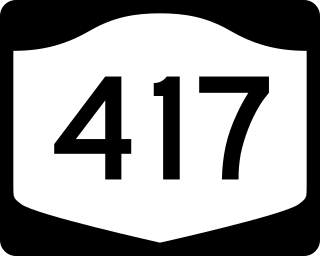
Interstate 86 spans east–west and is to the northern edge of Olean. New York Route 16 heads north from Olean to Buffalo. New York Route 417 heads east from Olean. Until 1968, the Pennsylvania Railroad operated the Buffalo Day Express heading north from Washington, D.C., through Olean to Buffalo (the Baltimore Day Express operated on the southbound version of the route).[19] The Penn Central railroad operated an unnamed successor train through Olean from Harrisburg, Pennsylvania to Buffalo between 1968 and May 1, 1971, when passenger train service in the region ended with the inception of Amtrak.[20][21]
Since 2001, the former Erie Lackawanna Railway mainline between Hornell, NY and Meadville, PA has been operated by the Western New York and Pennsylvania Railroad, a shortline railroad that has also operated portions of the former Pennsylvania Railroad Buffalo Line, both north and south of its Olean headquarters, since 2007.
Until January 6, 1970, the Erie Lackawanna Railroad operated through Olean with the Chicago - Hoboken, New Jersey " Lake Cities": the last passenger train to traverse the entire Southern Tier.[22] The Erie and the PRR train stations were about one mile (1.6km) apart.[23]
The nearest general commercial airports with scheduled flights for the public are in Erie, Buffalo and the Elmira area.[citation needed]
The Allegheny River is a 325-mile-long (523 km) tributary of the Ohio River that is located in western Pennsylvania and New York in the United States. It runs from its headwaters just below the middle of Pennsylvania's northern border, northwesterly into New York, then in a zigzag southwesterly across the border and through Western Pennsylvania to join the Monongahela River at the Forks of the Ohio at Point State Park in Downtown Pittsburgh, Pennsylvania.
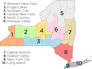
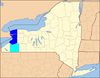
Cattaraugus County is a county in Western New York, with one side bordering Pennsylvania. As of the United States 2020 census, the population was 77,042. The county seat is Little Valley. The county was created in 1808 and later organized in 1817. The county is part of the Western New York region of the state.
Carrollton is a town in Cattaraugus County, New York, United States. The population was 1,214 at the 2020 census. The town was named after Guy Carrollton Irvine, an early settler of the region.
South Valley is a town in Cattaraugus County, New York, United States. The population was 250 at the 2020 census. The name is derived from the town's geographical attributes.
Coudersport is a borough in and the county seat of Potter County, Pennsylvania. It is located approximately 110 miles (180 km) east by south of Erie on the Allegheny River. The population was 2,371 at the 2020 census.
Cuba is a town on the western border of Allegany County, New York, United States. The village of Cuba lies within its borders. The federally recognized tribe of Seneca Native Americans has a reservation on the western town line. As of the 2020 Census, the total population was 3,154.
Allegany is a town in Cattaraugus County, New York, United States. The population was 7,493 at the 2020 census.
Little Valley is a town in Cattaraugus County, New York, United States. The population was 1,672 at the 2020 census. The town is named after its local geographical setting, a relative comparison of two tributaries of the Allegheny River.
Olean is a town in Cattaraugus County, New York, United States. The name is derived from the Latin word "oleum" due to the discovery of crude oil in nearby Ischua.
Portville is a town in Cattaraugus County, New York, United States. The population was 3,504 at the 2020 census. The name is derived from the town's early role in shipping lumber and other items down the Allegheny River. It was formed in 1837 from the town of Olean.
Salamanca is a city in Cattaraugus County, New York, United States, inside the Allegany Indian Reservation, one of two governed by the Seneca Nation of New York. The population was 5,929 at the 2020 census. It was named after José de Salamanca, a Spanish nobleman and cabinet minister of the mid-19th century. Salamanca invested in railroads around the globe, including the Atlantic and Great Western Railroad in New York State, Pennsylvania, and Ohio.
The Southern Tier is a geographic subregion of the broader Upstate region of New York State, geographically situated along or very near the state border with Pennsylvania. Definitions of the region vary widely, but generally encompass counties surrounding the Binghamton and Elmira-Corning metropolitan areas. This region is adjacent to the Northern Tier of Pennsylvania, and both these regions together are known as the Twin Tiers.
Western New York (WNY) is the westernmost region of the U.S. state of New York. The eastern boundary of the region is not consistently defined by state agencies or those who call themselves "Western New Yorkers". Almost all sources agree WNY includes the cities of Buffalo, Niagara Falls, Jamestown, and the surrounding suburbs, as well as the outlying rural areas of Niagara Frontier, and Chautauqua-Alleghany. Many would also place Rochester and the Genesee Valley in the region, although those legally belong in the Finger Lakes Region and are separate from Western New York Region.
The Genesee Valley Canal is a former canal that operated in western New York between 1840 and 1878. It ran for a length of 124 miles, passing through 106 locks. Its course was later used by the Genesee Valley Canal Railroad and today comprises portions of the Genesee Valley Greenway.
New York State Route 16 (NY 16) is a state highway in western New York, in the United States. It runs from the Pennsylvania state line, where it is one of the highest highways in the state in elevation, to downtown Buffalo. NY 16 is a major route through Erie County, despite the construction of the paralleling NY 400 freeway from East Aurora. In Cattaraugus County it also plays an important role, serving as the major connection from Olean to the Southern Tier Expressway. Between those two areas, and indeed for much of its length, it is a two-lane rural road.
New York State Route 417 (NY 417) is an east–west state highway located in the Southern Tier of New York in the United States. It begins at exit 20 of the Southern Tier Expressway in the city of Salamanca and ends at a junction with NY 415 in Painted Post, west of the city of Corning. At 105.25 miles (169.38 km) in length, NY 417 is the longest of the state highways that were formerly part of NY 17 before the construction of the Southern Tier Expressway. It also diverges the most from the current NY 17, coming within 100 feet (30 m) of the Pennsylvania state line at one intersection.
The Buffalo–Niagara Falls Metropolitan statistical area is a metropolitan area, designated by the United States Census Bureau, encompassing two counties - Erie and Niagara - in the state of New York. It has a population of over 1.1 million people and is the second-largest metropolitan area in the state. As of the 2020 US. census, the metropolitan statistical area (MSA) had a population of 1,166,902. The larger Buffalo Niagara Region is an economic zone consisting of eight counties in Western New York.
The Western New York and Pennsylvania Railroad is a short-line railroad that operates freight trains in Western New York and Northwest Pennsylvania. The company is controlled by the Livonia, Avon and Lakeville Railroad, with which it does not connect. It started operations in 2001 on the Southern Tier Extension, a former Erie Railroad line between Hornell, New York and Corry, Pennsylvania, owned by the public Chautauqua, Cattaraugus, Allegany and Steuben Southern Tier Extension Railroad Authority (STERA).
The Allegheny River Valley Trail is a 5.6-mile (9.0 km) rail trail in Cattaraugus County in western New York, United States. It was built on portions of the former Western New York and Pennsylvania Railway. It has two "loops" the main loop that crosses through Gargoyle Park, West State Street, Constitution Ave, as well as Saint Bonaventure University. There is a shorter alternative loop called the Saint Francis Loop which is 2.6 miles, loops around Saint Bonaventure's campus.
The New York & Pennsylvania Railroad (NYP) was a single track, shortline railroad running on a route described as east—west in the company's timetables, but closer to an arc: almost due south along Bennett's Creek from Canisteo through the hamlets of Greenwood, Rexville, and Whitesville, New York, southwest through Genesee, Pennsylvania to Oswayo, Pennsylvania, then northwest through Shinglehouse, Pennsylvania to Ceres, New York. In Canisteo trains made "a close connection" with "electric cars for Hornellsville". Trains connected in Canisteo with the Erie Railroad, with service to Buffalo and New York City; in Genesee with the Buffalo and Susquehanna Railroad, with service to Wellsville, New York, and in Ceres with the Pittsburg [sic], Shawmutt, and Northern Railroad, with service to Olean, New York, and points west. While the railroad did not serve Hornell, occasionally it did run special trains, using the Erie tracks. Its route was primarily in southwestern Steuben County, New York, and northern Potter County, Pennsylvania, with small portions in Allegany County, New York, and McKean County, Pennsylvania. Total track was 56.13 miles (90.33 km) main line and 7.69 miles (12.38 km) of sidings.
↑ [Robb, Gary C. (1979) "Police Use of CCTV Surveillance: Constitutional Implications and Proposed Regulations" University of Michigan Journal of Law Reform. pg. 572]
This page is based on this Wikipedia article Text is available under the CC BY-SA 4.0 license; additional terms may apply. Images, videos and audio are available under their respective licenses.