
Cattaraugus County is a county in Western New York, with one side bordering Pennsylvania. As of the United States 2020 census, the population was 77,042. The county seat is Little Valley. The county was created in 1808 and later organized in 1817.

Madison County is a county located in the U.S. state of New York. As of the 2020 census, the population was 68,016. Its county seat is Wampsville. The county is named after James Madison, the fourth president of the United States, and was first formed in 1806.

Allegany Reservation is a Seneca Nation of Indians reservation in Cattaraugus County, New York, U.S. In the 2000 census, 58 percent of the population within the reservation boundaries were Native Americans. Some 42% were European Americans; they occupy properties under leases from the Seneca Nation, a federally recognized tribe. The population outside of the rented towns was 1,020 at the 2010 census. The reservation's Native American residents are primarily members of the Seneca, but a smaller number of Cayuga, another Iroquois nation, also reside there, and at least one family is known to have descended from the Neutral Nation. Prior to the 17th century, this area was occupied by the Iroquoian-speaking Wenrohronon and Eriehronon. The more powerful Seneca eliminated these competing groups during the Beaver Wars beginning in 1638, as the Iroquois Confederacy sought to control the lucrative fur trade with the French and Dutch colonists.

The Tonawanda Indian Reservation is an Indian reservation of the Tonawanda Seneca Nation located in western New York, United States. The band is a federally recognized tribe and, in the 2010 census, had 693 people living on the reservation. The reservation lies mostly in Genesee County, extending into Erie and Niagara counties. It is bordered by the Towns of Alabama, Pembroke, Newstead, and Royalton.
Salamanca is a town in Cattaraugus County, New York, United States. The population was 470 at the 2020 census. The name is from José de Salamanca y Mayol, Marquis of Salamanca, a major Spanish investor in the Atlantic and Great Western Railroad, a local railroad.
The Seneca are a group of Indigenous Iroquoian-speaking people who historically lived south of Lake Ontario, one of the five Great Lakes in North America. Their nation was the farthest to the west within the Six Nations or Iroquois League (Haudenosaunee) in New York before the American Revolution. For this reason, they are called “The Keepers of the Western Door.”

The Holland Land Company was an unincorporated syndicate of thirteen Dutch investors from Amsterdam, headquartered in Philadelphia, who purchased large tracts of American land for development and speculation. Their primary purchase was that of the western two-thirds of the Phelps and Gorham Purchase in 1792 and 1793, an area that afterward was known as the Holland Purchase. Additional lands were purchased in northwest Pennsylvania. Aliens were forbidden from owning land within New York State, except by special acts of the New York State Legislature, so investors placed their funds in the hands of certain trustees who bought the land in central and western New York State. The syndicate hoped to sell the land rapidly at a great profit. Instead, for many years they were forced to make further investments in their purchase; surveying it, building roads, digging canals, to make it more attractive to settlers. They influenced state policy in New York to allow foreign ownership of the land, avoid new taxes, and promote the construction of the Erie Canal and government roads on the company lands. They supported Governor Dewitt Clinton's faction in the state government to achieve these goals. The company finished selling its New York lands in 1839 and its Pennsylvania lands in 1849, and the company was liquidated in 1858.

The Phelps and Gorham Purchase was the sale, in 1788, of a portion of a large tract of land in western New York State owned by the Seneca nation of the Iroquois Confederacy to a syndicate of land developers led by Oliver Phelps and Nathaniel Gorham. The larger tract of land is generally known as the "Genesee tract" and roughly encompasses all that portion of New York State west of Seneca Lake, consisting of about 6,000,000 acres (24,000 km2).
There are four treaties of Buffalo Creek, named for the Buffalo River in New York. The Second Treaty of Buffalo Creek, also known as the Treaty with the New York Indians, 1838, was signed on January 15, 1838 between the Seneca Nation, Mohawk nation, Cayuga nation, Oneida Indian Nation, Onondaga (tribe), Tuscarora (tribe) and the United States. It covered land sales of tribal reservations under the U.S. Indian Removal program, by which they planned to move most eastern tribes to Kansas Territory west of the Mississippi River.
The Tonawanda Seneca Nation is a federally recognized tribe in the State of New York. They have maintained the traditional form of government led by sachems selected by clan mothers. The Seneca are one of the original Five Nations of the Haudenosaunee or Iroquois Confederacy. Their people speak the Seneca language, an Iroquoian language.
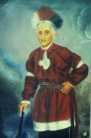
Tah-won-ne-ahs or Thaonawyuthe, known in English as either Chainbreaker to his own people or Governor Blacksnake to the European settlers, was a Seneca war chief and sachem. Along with other Iroquois war chiefs, he led warriors to fight on the side of the British during the American Revolutionary War from 1777 to 1783. He was prominent for his role at the Battle of Oriskany, in which the Loyalist and allied forces ambushed a force of Patriots. After the war, he supported his maternal uncle, Handsome Lake, as a prominent religious leader. Chainbreaker allied with the United States in the War of 1812 and later encouraged some accommodation to European-American settlers, allowing missionaries and teachers on the Seneca reservation.
Canawaugus was a Seneca Indian village. The village was located on the west side of the Genesee River, "about a mile above the ford", on the eastern edge of the Town of Caledonia. It was nearly opposite of the Avon sulphur springs. The name means "stinking waters" because of the sulphur.

The Buffalo Creek Reservation was a tract of land surrounding Buffalo Creek in the central portion of Erie County, New York. It contained approximately 49,920 acres (202.0 km2) of land and was set aside for the Seneca Nation following negotiations with the United States after the American Revolutionary War.

The Seneca–Cayuga Nation is one of three federally recognized tribes of Seneca people in the United States. It includes the Cayuga people and is based in Oklahoma, United States. The tribe had more than 5,000 people in 2011. They have a tribal jurisdictional area in the northeast corner of Oklahoma and are headquartered in Grove. They are descended from Iroquoian peoples who had relocated to Ohio from New York state in the mid-18th century.
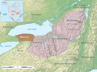
The Wenrohronon or Wenro people were an Iroquoian indigenous nation of North America, originally residing in present-day western New York, who were conquered by the Confederation of the Five Nations of the Iroquois in two decisive wars between 1638–1639 and 1643. This was likely part of the Iroquois Confederacy campaign against the Neutral people, another Iroquoian-speaking tribe, which lived across the Niagara River. This warfare was part of what was known as the Beaver Wars, as the Iroquois worked to dominate the lucrative fur trade. They used winter attacks, which were not usual among Native Americans, and their campaigns resulted in attrition of both the larger Iroquoian confederacies, as they had against the numerous Huron.
The Seneca Nation of Indians is a federally recognized Seneca tribe based in western New York. They are one of three federally recognized Seneca entities in the United States, the others being the Tonawanda Band of Seneca and the Seneca-Cayuga Nation of Oklahoma. Some Seneca also live with other Iroquois peoples on the Six Nations of the Grand River in Ontario.
The Treaty of Big Tree was a formal treaty signed in 1797 between the Seneca Nation and the United States, in which the Seneca relinquished their rights to nearly all of their traditional homeland in New York State—nearly 3.5 million acres. In the 1788 Phelps and Gorham Purchase, the Haudenosaunee (Iroquois) had previously sold rights to their land between Seneca Lake and the Genesee River. The Treaty of Big Tree signed away their rights to all their territory west of the Genesee River except 12 small tracts of land for $100,000 and other considerations. The money was not paid directly to the tribe, but was to be invested in shares of the Bank of the United States, and to be paid out to the Senecas in annual earnings of up to six percent, or $6,000 a year, on the bank stock.
Jimerson Town is a native planned community on the Allegany Indian Reservation within the bounds of Cattaraugus County, New York. Along with Irving on the Cattaraugus Reservation, Jimerson Town is one of two capitals of the Seneca Nation of Indians.
The Third Treaty of Buffalo Creek or Treaty with the Seneca of 1842 signed by the U.S. and the Seneca Nation modified the Second Treaty of Buffalo Creek. This reflected that the Ogden Company had purchased only two of the four Seneca reservations, the Buffalo Creek and Tonawanda reservations, that the Senecas had agreed to sell in the Second Treaty; it thus restored native title to the Allegany, Cattaraugus and Oil Springs reservations.

Maris Bryant Pierce, was a Seneca Nation chief, lawyer, and teacher. He was a tribal land-rights activist, and a major influence to the Second Treaty of Buffalo Creek of 1838.


