Red House is a town in Cattaraugus County, New York, United States. As of the 2020 census, the town population was 30, making it the least populous town in the state. The town is on the south edge of Cattaraugus County, south of the city of Salamanca.
Salamanca is a city in Cattaraugus County, New York, United States, inside the Allegany Indian Reservation, one of two governed by the Seneca Nation of New York. The population was 5,929 at the 2020 census. It was named after José de Salamanca, a Spanish nobleman and cabinet minister of the mid-19th century. Salamanca invested in railroads around the globe, including the Atlantic and Great Western Railroad in New York State, Pennsylvania, and Ohio.

New York State Route 417 (NY 417) is an east–west state highway located in the Southern Tier of New York in the United States. It begins at exit 20 of the Southern Tier Expressway in the city of Salamanca and ends at a junction with NY 415 in Painted Post, west of the city of Corning. At 105.25 miles (169.38 km) in length, NY 417 is the longest of the state highways that were formerly part of NY 17 before the construction of the Southern Tier Expressway. It also diverges the most from the current NY 17, coming within 100 feet (30 m) of the Pennsylvania state line at one intersection.

U.S. Route 219 (US 219) is a part of the U.S. Highway System that runs from Rich Creek, Virginia, to West Seneca, New York. In the U.S. state of New York, US 219 extends 67.63 miles (108.84 km) from the Pennsylvania state line at Carrollton to an interchange with the New York State Thruway at exit 55 in West Seneca, southeast of downtown Buffalo. In Cattaraugus County, the area surrounding US 219 is predominantly rural. However, in northern Cattaraugus County, US 219 becomes a freeway leading through Erie County and into the heart of Buffalo. The route serves the villages of Ellicottville and Springville, where it meets New York State Route 242 (NY 242) and NY 39, respectively, and indirectly serves Hamburg via NY 391.
Alpha is an unincorporated community in Clinton County, Kentucky, United States. It lies along Route 90 northeast of the city of Albany, the county seat of Clinton County. Its elevation is 1,014 feet (309 m), and it is located at 36°45′44″N85°0′37″W. It has a post office with the ZIP code 42603.
Crockett is an unincorporated community in Morgan County, Kentucky, United States. It lies along Route 172 northeast of the city of West Liberty, the county seat of Morgan County. Its elevation is 912 feet (278 m). It has a post office with the ZIP code 41413.
Center Point is an unincorporated community in northeastern Doddridge County, West Virginia, United States. It lies along Route 23 northeast of the town of West Union, the county seat of Doddridge County. Its elevation is 791 feet (241 m).
Brohard is an unincorporated community in Ritchie and Wirt counties in the U.S. state of West Virginia. Its elevation is 965 feet (294 m). Brohard had a post office, which closed on November 2, 2002.
Creston is an unincorporated community in southeastern Wirt County, West Virginia, United States. It lies at the confluence of the Little Kanawha River and the West Fork Little Kanawha River on West Virginia Route 5, southeast of the town of Elizabeth, the county seat of Wirt County. Its elevation is 653 feet (199 m). Creston had a post office, which closed on June 25, 2011. The community was named for a drainage divide near the town site.

Ames is an unincorporated hamlet in southern Dodge County, Nebraska, United States. As of the 2010 census it had a population of 24.
Flint is an unincorporated community in southeastern Smith County, Texas, United States. It lies along FM 2493, south of the city of Tyler, the county seat of Smith County. Its elevation is 522 feet (159 m). Although Flint is unincorporated, it has a post office, with the ZIP code of 75762.
Elko was a town in Cattaraugus County, New York that existed from 1890 to 1965. It was forcibly evacuated in 1965 due to the construction of the Kinzua Dam on the Allegheny River in Warren County, Pennsylvania, one of the largest dams in the United States east of the Mississippi. The dam was authorized by the United States Congress as a flood control measure in the Flood Control Acts of 1936 and 1938, and was built by the U. S. Army Corps of Engineers beginning in 1960. Other benefits from the dam include drought control, hydroelectric power production, and recreation.
Eldred is a rural hamlet located in the central part of the town of Highland, Sullivan County, New York, United States. The community is located along New York State Route 55, approximately 13.5 miles (21.7 km) southwest of Monticello. Eldred has a post office, which opened on October 5, 1831, with the current ZIP code as 12732. Other points of interest in the hamlet include the Highland Town Hall, Sunshine Hall Free Library, a firehouse, several churches and parks, and a Dollar General store. Public education in Eldred is serviced through the Eldred Central School District.
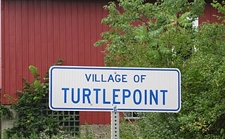
Turtlepoint is an unincorporated community in Annin Township, McKean County, Pennsylvania, United States. The community is located along Pennsylvania Route 155, approximately 5.2 miles (8.4 km) northwest of Port Allegany. Turtlepoint has a post office with ZIP code 16750. The Allegheny River flows through the area.
South Otselic is a hamlet in Chenango County, New York, United States.
West Leyden is a hamlet in Lewis County, New York, United States. The community is located in the town of Lewis along the East Branch of the Mohawk River at the intersection of New York State Route 26 and New York State Route 294, 6.6 miles (10.6 km) west-southwest of Boonville. West Leyden has a post office with ZIP code 13489, which opened on December 16, 1826. Today West Leyden is home to approximately 250 residents, a grocery store/gas station, church, two restaurants, garbage company, Volunteer Fire and Ambulance Department and Elementary School.
East Branch is a hamlet in Delaware County, New York, United States. The community is located at the confluence of the East Branch Delaware River and Beaver Kill and along New York State Route 17, 7.9 miles (12.7 km) east-northeast of Hancock. East Branch has a post office with the ZIP Code 13756.
Fishs Eddy is a hamlet in Delaware County, New York, United States. The community is located along the East Branch Delaware River, 5.5 miles (8.9 km) east of Hancock, off New York State Route 17 at Exit 89. Fishs Eddy has a post office with ZIP code 13774.
Seneca Castle is a hamlet in Ontario County, New York, United States. The community is 5.8 miles (9.3 km) west-northwest of Geneva. Seneca Castle has a post office with ZIP code 14547.
Little Genesee is a hamlet in Allegany County, New York, United States. The community is located along New York State Route 417, 3.4 miles (5.5 km) southwest of Bolivar. Little Genesee has a post office with ZIP code 14754, which opened on August 6, 1845.


