East Otto, New York

Last updated

East Otto, New York
U.S. Post Office East Otto NY Aug 10.JPG
East Otto Post Office, August 2010
USA New York location map.svg
Red pog.svg
East Otto
Location within the state of New York
Coordinates: 42°23′19″N78°44′28″W / 42.38861°N 78.74111°W / 42.38861; -78.74111
Country United States
State New York
County Cattaraugus
Government
  Type Town Council
   Town Supervisor James A. Beach (R)
   Town Council
Members' List
Area
[1]
  Total41.46 sq mi (107.39 km2)
  Land41.14 sq mi (106.54 km2)
  Water0.33 sq mi (0.84 km2)
Elevation
1,522 ft (464 m)
Population
 (2020) [2]
  Total977
  Estimate 
(2021) [2]
971
  Density25.55/sq mi (9.86/km2)
Time zone UTC-5 (Eastern (EST))
  Summer (DST) UTC-4 (EDT)
ZIP code
14729
Area code 716
FIPS code 36-009-22678
GNIS feature ID0978921
Website eastottony.org
Winter scene in East Otto, January 1998 Winter Scene in East Otto, New York, January 1998.jpg
Winter scene in East Otto, January 1998

East Otto is a town in Cattaraugus County, New York, United States. The population was 977 at the 2020 census. [2] The town, along with neighboring Otto, is named after an agent of the Holland Land Company, Jacob Otto. The town of East Otto is on the northern border of the county.

Contents

History

The town of East Otto was founded in 1854. As its name implies, the town was formed from the eastern half of the town of Otto, which at the time covered most of the north-central portion of the county. East Otto was one of the last towns to be formed in Cattaraugus County.

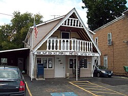
The East Otto Union School, which was constructed in 1920 and now serves as a town hall, is listed on the National Register of Historic Places. [3]

Geography

According to the United States Census Bureau, the town has a total area of 40.4 square miles (104.6 km2), of which 40.1 square miles (103.8 km2) is land and 0.31 square miles (0.8 km2), or 0.81%, is water. [4]

The north town line is marked by Cattaraugus Creek and is the border of Erie County.

Cattaraugus County Route 12 is the primary highway through the area, heading westward toward Otto and northward to U.S. Route 219 in Ashford. Cattaraugus County Route 14 (Reed Hill Road) heads southward toward Little Valley, while Cattaraugus County Route 75 (Plato Road) travels east/southeast to US 219 along a more southerly route. Routes 12, 14, and 75 converge at the hamlet of East Otto.

Demographics

Historical population
CensusPop.Note
1860 1,300
1870 1,164−10.5%
1880 1,2517.5%
1890 1,2883.0%
1900 1,138−11.6%
1910 1,093−4.0%
1920 915−16.3%
1930 751−17.9%
1940 732−2.5%
1950 7431.5%
1960 701−5.7%
1970 91029.8%
1980 9423.5%
1990 1,0036.5%
2000 1,10510.2%
2010 1,062−3.9%
2020 977−8.0%
2021 (est.)971 [2] −0.6%
U.S. Decennial Census [5]

As of the census [6] of 2000, there were 1,105 people, 412 households, and 285 families residing in the town. The population density was 26.8 inhabitants per square mile (10.3/km2). There were 545 housing units at an average density of 13.2 per square mile (5.1/km2). The racial makeup of the town was 98.37% White, 0.45% African American, 0.09% Native American, 0.27% Asian, 0.36% from other races, and 0.45% from two or more races. Hispanic or Latino of any race were 0.72% of the population.

There were 412 households, out of which 34.7% had children under the age of 18 living with them, 58.3% were married couples living together, 7.0% had a female householder with no husband present, and 30.8% were non-families. 21.1% of all households were made up of individuals, and 6.1% had someone living alone who was 65 years of age or older. The average household size was 2.68 and the average family size was 3.14.

In the town, the population was spread out, with 27.2% under the age of 18, 7.6% from 18 to 24, 30.7% from 25 to 44, 24.2% from 45 to 64, and 10.3% who were 65 years of age or older. The median age was 37 years. For every 100 females, there were 106.9 males. For every 100 females age 18 and over, there were 108.3 males.

The median income for a household in the town was $36,250, and the median income for a family was $42,917. Males had a median income of $31,917 versus $20,795 for females. The per capita income for the town was $15,607. About 10.2% of families and 12.2% of the population were below the poverty line, including 15.2% of those under age 18 and 12.0% of those age 65 or over.

Communities and locations in East Otto

Adjacent towns and areas

Griffis Sculpture Park Griffis sculpture park1.JPG
Griffis Sculpture Park

(Clockwise)

Notable people

Related Research Articles

Ashford is a town in Cattaraugus County, New York, United States. The population was 1,974 at the 2020 census. The town is on the county's northern border.

<span class="mw-page-title-main">Carrollton, New York</span> Town in New York, United States

Carrollton is a town in Cattaraugus County, New York, United States. The population was 1,214 at the 2020 census. The town was named after Guy Carrollton Irvine, an early settler of the region.

Conewango is a town in Cattaraugus County, New York, United States. The population was 1,794 at the 2020 census. The town is named after a creek which flows through the town.

<span class="mw-page-title-main">Dayton, New York</span> Town in New York, United States

Dayton is a town in Cattaraugus County, New York, United States. The population was 1,689 at the 2020 census. The town is on the western border of Cattaraugus County.

Farmersville is a town located in the eastern border of Cattaraugus County, New York, United States. The population was 1,081 at the 2020 census.

Freedom is a town in Cattaraugus County, New York, United States. The population was 2,244 at the 2021 census. The town is in the northeast corner of Cattaraugus County.

<span class="mw-page-title-main">Hinsdale, New York</span> Town in New York, United States

Hinsdale is a town in Cattaraugus County, New York, United States. The population was 2,119 at the 2020 census. The town was named after Hinsdale in New Hampshire.

<span class="mw-page-title-main">Machias, New York</span> Town in New York, United States

Machias is a town in Cattaraugus County, New York, United States. The population was 2,309 at the 2020 census. Machias is an interior town in the northeast quadrant of the county. It is northeast of the city of Salamanca.

Mansfield is a town in Cattaraugus County, New York, United States. The population was 843 at the 2020 census. The name was thought to be that of a noble family in England.

<span class="mw-page-title-main">New Albion, New York</span> Town in New York, United States

New Albion is a town in Cattaraugus County, New York, United States. The population was 1,990 at the 2020 census. The town is named after Albion in Orleans County, the source of some early settlers. New Albion is in the northwest quadrant of the county, northwest of the city of Salamanca.

<span class="mw-page-title-main">Otto, New York</span> Town in New York, United States

Otto is a town in Cattaraugus County, New York, United States. The population was 775 at the 2020 census. The name comes from Jacob S. Otto, an agent of the Holland Land Company. The town lies on the northern border of Cattaraugus County.

<span class="mw-page-title-main">Hanover, New York</span> Town in New York, United States

Hanover is a town in Chautauqua County, New York, United States. The population was 6,893 at the 2020 census. The town lies in the northeast corner of Chautauqua County.

<span class="mw-page-title-main">Concord, New York</span> Town in New York, United States

Concord is a town in Erie County, New York, United States. The population was 8,494 at the 2010 census. The town is believed to be named after Concord, Massachusetts, by early settlers from New England.

<span class="mw-page-title-main">Java, New York</span> Town in New York, United States

Java is an incorporated town in Wyoming County, New York. The population was 2,057 at the 2010 census. The Town of Java is on the western border of Wyoming County.

Allegany is a town in Cattaraugus County, New York, United States. The population was 7,493 at the 2020 census.

<span class="mw-page-title-main">Ellicottville, New York</span> Town in New York, United States

Ellicottville is a town in Cattaraugus County, New York, United States. The population was 1,317 at the 2020 census. The town is named after Joseph Ellicott, principal land agent of the Holland Land Company.

Perrysburg is a town in Cattaraugus County, New York, United States. The population was 1,515 at the 2020 census. The town is named after Commodore Oliver Hazard Perry and is located in the northwest corner of the county. The town contains the census-designated place also named Perrysburg, formerly an incorporated village.

Randolph is a town in Cattaraugus County, New York, United States. The population was 2,470 at the 2020 census. The town was named after Randolph, Vermont.

<span class="mw-page-title-main">Yorkshire, New York</span> Town in New York, United States

Yorkshire is a town in Cattaraugus County, New York, United States. The population was 3,840 at the 2020 census. The town is located on the northern edge and in the northeast quadrant of the county.

<span class="mw-page-title-main">Arcade, New York</span> Town in New York, United States

Arcade is a town in Wyoming County, New York, United States. The population was 4220 at the 2020 census.

References

  1. "2016 U.S. Gazetteer Files". United States Census Bureau. Retrieved July 4, 2017.
  2. 1 2 3 4 Bureau, US Census. "City and Town Population Totals: 2020-2021". Census.gov. US Census Bureau. Retrieved July 4, 2022.
  3. "National Register Information System". National Register of Historic Places . National Park Service. March 13, 2009.
  4. "Geographic Identifiers: 2010 Demographic Profile Data (G001): East Otto town, Cattaraugus County, New York". U.S. Census Bureau, American Factfinder. Archived from the original on February 12, 2020. Retrieved October 23, 2014.
  5. "Census of Population and Housing". Census.gov. Retrieved June 4, 2015.
  6. "U.S. Census website". United States Census Bureau . Retrieved January 31, 2008.

42°23′23″N78°45′17″W / 42.38972°N 78.75472°W / 42.38972; -78.75472