Poospatuck Reservation

Last updated
Poospatuck Reservation, New York
Poospatuck-reservation.gif
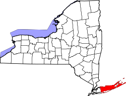
Map of Poospatuck Reservation
9300R Poospatuck (state) Reservation Locator Map.svg
Location of Poospatuck Reservation
Coordinates: 40°47′23″N72°49′58″W / 40.78972°N 72.83278°W / 40.78972; -72.83278
Country United States
State New York
County Suffolk
Area
  Land0.1130 sq mi (0.2927 km2)
  Water0.0562 sq mi (0.1456 km2)
Elevation
17 ft (5 m)
Population
 (2020)
  Total436
  Density3,858.4/sq mi (1,489.6/km2)
Time zone UTC-5 (Eastern (EST))
  Summer (DST) UTC-4 (EDT)
ZIP code
11950
Area code(s) 631, 934
GNIS feature ID979384

The Poospatuck Reservation is a Native American reservation of the Unkechaugi band in the community of Mastic, Suffolk County, New York, United States. It is one of two Native American reservations in Suffolk County, the other being the Shinnecock Reservation. The population was 436 at the 2020 census.

Contents

The Unkechaugi are descendants of the Quiripi-speaking Native Americans, who occupied much of southern New England and central Long Island at the time of European encounter in the colonial era. Historically they spoke an Algonquian language. They have retained a community; the reservation is the smallest in New York State. The current 55 acre reservation was originally set aside for the Unkechaugs as a 175-acre plot by William "Tangier" Smith after he purchased large tracts of land from Unkechaug John Mayhew in 1691. [1] It is located in Mastic on the north side of Poospatuck Creek, on the east side of Poospatuck Lane, and south of Eleanor Avenue. Poospatuck is situated in the southeast corner of Suffolk County's present-day Town of Brookhaven; and is the township's sole Indian reservation. On account of the innumerable tobacco shops, the reservation is known synecdochally as "Mastic Boges" by those in neighboring towns. It is about 70 miles or 1½ hours east of New York City.

The reservation and its people are recognized as Native American by the state of New York but it has not received federal recognition from the US Bureau of Indian Affairs. However, the Unkechaug established that it met the criteria of a Tribe set out in the Supreme Court case Montoya v. United States, 180 U.S. 261, 266 (1901). The Unkechaug proved beyond a preponderance of the evidence that they met the criteria of a common law definition of a tribe consisting of the following: 1. A body of Indians of the same or similar race; 2. United in a community under one leadership or government; 3. Inhabiting a particular though sometimes ill-defined territory. Federal District Judge Kiyo Matsomoto held that the Unkechaug satisfied all 3 Montoya criteria thereby entitling the Unkechaug to Sovereign Immunity from lawsuits because they are a federal Tribe under federal common law. [2]

Geography

According to the United States Census Bureau, the Indian reservation has a land area of 72.3 acres (0.293 km2), and a water area of 36 acres (0.15 km2). The reservation reports the size of the reservation is actually 55 acres (0.22 km2). [3]

Demographics

Historical population
CensusPop.Note
1970 125
1980 20362.4%
1990 136−33.0%
2000 27199.3%
2010 32419.6%
2020 43634.6%
U.S. Decennial Census [4]

As of the census of 2000, there were 271 people, 93 households, and 67 families residing in the Indian reservation. The population density was 3,040.9/mi2 (1,162.6/km2). There were 100 housing units at an average density of 1,122.1 inhabitants/mi2 (429.0 inhabitants/km2). The racial makeup of the Indian reservation was 1.48% White, 12.92% African American, 79.34% Native American (mostly Unkechaug people), no Asians, no Pacific Islanders, 0.74% from other races, and 5.54% from two or more races. 4.80% of the population were Hispanic or Latino of any race.

There were 93 households, out of which 47.3% had children under the age of 18 living with them, 29.0% were married couples living together, 32.3% had a woman whose husband does not live with her, and 26.9% were non-families. 24.7% of all households were made up of individuals, and 2.2% had someone living alone who was 65 years of age or older. The average household size was 2.91 and the average family size was 3.51.

In the Indian reservation the population was spread out, with 36.5% under the age of 18, 10.0% from 18 to 24, 30.3% from 25 to 44, 17.3% from 45 to 64, and 5.9% who were 65 years of age or older. The median age was 27 years. For every 100 females, there were 78.3 males. For every 100 females age 18 and over, there were 79.2 males.

The median income for a household in the Indian reservation was $13,125, and the median income for a family was $17,500. Males had a median income of $47,500 versus $20,250 for females. The per capita income for the Indian reservation was $8,127. 36.6% of the population and 36.8% of families were below the poverty line. Out of the total people living in poverty, 46.6% were under the age of 18 and 25.0% were 65 or older. [5]

Related Research Articles

<span class="mw-page-title-main">Bennett County, South Dakota</span> County in South Dakota, United States

Bennett County is a county in the U.S. state of South Dakota. As of the 2020 census, the population was 3,381. Its county seat is Martin. The county lies completely within the exterior boundary of the Pine Ridge Indian Reservation. To the east is the Rosebud Indian Reservation, where dwell the Sicangu Oyate, also known the Upper Brulé Sioux Nation and the Rosebud Sioux Tribe (RST), a branch of the Lakota people.

<span class="mw-page-title-main">Venetie, Alaska</span> CDP in Alaska, United States

Venetie, is a census-designated place (CDP) in Yukon–Koyukuk Census Area, Alaska. At the 2010 census, the population was 166, down from 202 in 2000. It includes the Village of Venetie, a Gwich'in tribal entity designated in the 1971 Alaska Native Claims Settlement Act.

<span class="mw-page-title-main">Crystal Lake, Connecticut</span> Census-designated place in Connecticut, United States

Crystal Lake is a village, census-designated place, and part of the town of Ellington, in Tolland County, Connecticut, United States. The population was 1,945 at the 2010 census. The CDP includes an eponymous lake.

<span class="mw-page-title-main">Hanover, Kansas</span> City in Washington County, Kansas

Hanover is a city in Washington County, Kansas, United States. As of the 2020 census, the population of the city was 690.

Charenton is a census-designated place (CDP) in St. Mary Parish, Louisiana, United States. The population was 1,903 at the 2010 census. It is part of the Morgan City Micropolitan Statistical Area. According to legend, the community received its name from one of the earliest settlers of the region, Alexandre Frere. Frere, a native of Paris, reportedly exclaimed on his deathbed that "anyone choosing to move to that part of Louisiana belonged in Charenton!" Charenton was the name of a notorious insane asylum outside of Paris.

<span class="mw-page-title-main">Red Lake, Minnesota</span> Census-designated place in Minnesota, US

Red Lake is a census-designated place (CDP) within the Lower Red Lake unorganized territory located in Beltrami County, Minnesota, United States. As of the 2020 census, Red Lake had a total population of 1,786. The Red Lake Indian Reservation is based in Red Lake.

<span class="mw-page-title-main">Pender, Nebraska</span> Village in and county seat of Thurston County, Nebraska, United States

Pender is a village in and the county seat of Thurston County, Nebraska, United States. On March 22, 2016, the United States Supreme Court resolved a disagreement as to whether Pender is located on the Omaha Indian Reservation, holding unanimously that "the disputed land is within the reservation’s boundaries." The predominantly European-American population was 1,115 at the 2020 census.

<span class="mw-page-title-main">Mastic, New York</span> Hamlet and census-designated place in New York, United States

Mastic is a hamlet and a census-designated place (CDP) in the southeastern part of the town of Brookhaven in central Suffolk County, New York, United States. The population was 15,481 at the 2010 census.

<span class="mw-page-title-main">Rosebud, South Dakota</span> CDP in South Dakota, United States

Rosebud also Sicanġu is a census-designated place (CDP) in Todd County, South Dakota, United States. The population was 1,455 at the 2020 census.

<span class="mw-page-title-main">Nisqually Reservation</span> CDP in Washington, United States

The Nisqually Reservation, also known as Nisqually Indian Reservation is a federally recognized Indian reservation in Thurston County, Washington, United States. The population was 668 at the 2020 census.

<span class="mw-page-title-main">Passamaquoddy Indian Township Reservation</span> Indian reservation in Maine, United States

Passamaquoddy Indian Township Reservation is one of two Indian reservations of the federally recognized Passamaquoddy tribe in Washington County, Maine, United States. The population was 760 at the 2020 census. Most of the 2,500 members of the tribe in the United States live in other parts of Maine. The reservation is located about 13 miles west-northwest of the city of Calais.

<span class="mw-page-title-main">Allegany Indian Reservation</span> Indian Reservation in New York, United States

Allegany Reservation is a Seneca Nation of Indians reservation in Cattaraugus County, New York, U.S. In the 2000 census, 58 percent of the population within the reservation boundaries were Native Americans. Some 42% were European Americans; they occupy properties under leases from the Seneca Nation, a federally recognized tribe. The population outside of the rented towns was 1,020 at the 2010 census. The reservation's Native American residents are primarily members of the Seneca, but a smaller number of Cayuga, another Iroquois nation, also reside there, and at least one family is known to have descended from the Neutral Nation. Prior to the 17th century, this area was occupied by the Iroquoian-speaking Wenrohronon and Eriehronon. The more powerful Seneca eliminated these competing groups during the Beaver Wars beginning in 1638, as the Iroquois Confederacy sought to control the lucrative fur trade with the French and Dutch colonists.

<span class="mw-page-title-main">Tuscarora Reservation</span>

The Tuscarora Reservation also known as the Tuscaroran Indian Nation is an Indian reservation in Niagara County, New York. The population was 1,152 at the 2010 census. The Tuscarora are a federally recognized tribe and the Sixth Nation of the Haudenosaunee or Iroquois Confederacy active before the American Revolutionary War.

<span class="mw-page-title-main">Onondaga Reservation</span> Indian reservation in New York, United States

Onondaga Reservation is a Native American reservation in Onondaga County, New York, United States. It is the territory of the Onondaga Nation. It lies just south of the city of Syracuse. The population was 2,244 at the 2010 census.

<span class="mw-page-title-main">Shinnecock Reservation</span> Indian Reservation in New York, United States

Shinnecock Reservation is a Native American reservation for members of the Shinnecock Indian Nation in the town of Southampton in Suffolk County, New York, United States. It is the most easterly of the two Native American reservations in Suffolk County; the other being Poospatuck Reservation in the town of Brookhaven. It lies on the east side of Shinnecock Bay on southeastern Long Island, near Tuckahoe, Shinnecock Hills, and the village of Southampton. The population was 819 as of the 2020 census. Roughly that many tribal members additionally live off the reservation.

<span class="mw-page-title-main">Penobscot Indian Island Reservation</span> Indian reservation in United States, Penobscot

Penobscot Indian Island Reservation is an Indian reservation for the Penobscot Tribe of Maine, a federally recognized tribe of the Penobscot in Penobscot County, Maine, United States, near Old Town. The population was 758 at the 2020 census. The reservation extends for many miles alongside 15 towns and two unorganized territories in a thin string along the Penobscot River, from its base at Indian Island, near Old Town and Milford, northward to the vicinity of East Millinocket, almost entirely in Penobscot County. A small, uninhabited part of the reservation used as a game preserve and hunting and gathering ground is in South Aroostook, Aroostook County, by which it passes along its way northward.

Cattaraugus Reservation is an Indian reservation located partly in Cattaraugus County, New York, United States. The population was 314 at the 2010 census. The majority of the residents are of the federally recognized Seneca Nation, one of the original Five Nations of the Iroquois Confederacy.

The Cattaraugus Reservation is an Indian reservation of the Seneca Nation of New York, located partly in Chautauqua County, New York, United States. The population of this portion of the reservation was 38 at the 2010 census. Most of the inhabitants are of the Seneca tribe.

<span class="mw-page-title-main">Cattaraugus Reservation, Erie County, New York</span> Indian reservation in New York, US

Cattaraugus Reservation is an Indian reservation located partly in Erie County, New York, United States. The population was 1,833 at the 2010 census.

<span class="mw-page-title-main">Tonawanda Reservation</span> Indian reservation in New York, United States

The Tonawanda Indian Reservation is an Indian reservation of the Tonawanda Seneca Nation located in western New York, United States. The band is a federally recognized tribe and, in the 2010 census, had 693 people living on the reservation. The reservation lies mostly in Genesee County, extending into Erie and Niagara counties. It is bordered by the Towns of Alabama, Pembroke, Newstead, and Royalton.

References

  1. Illustrated History of the Moriches Bay Area by Van and Mary Field suffolk.lib.ny.us - retrieved November 12, 2007
  2. "Gristede's Foods, Inc. v. Unkechauge Nation, 660 F. Supp. 2d 442 | Casetext Search + Citator". casetext.com. Retrieved 2024-07-14.
  3. Newsday.com
  4. "Census of Population and Housing". Census.gov. Retrieved June 4, 2015.
  5. Center for New Media & Promotion (CNMP), US Census Bureau. "My Tribal Area". www.census.gov. Retrieved 2024-07-14.