East Shoreham, New York

Last updated

East Shoreham, New York
Shoreham Nuclear Power Plant.jpg
East-shoreham-ny.png
U.S. Census map
USA New York location map.svg
Red pog.svg
East Shoreham
Location within the state of New York
Coordinates: 40°57′1″N72°53′7″W / 40.95028°N 72.88528°W / 40.95028; -72.88528
Country United States
State New York
County Suffolk
Area
[1]
  Total6.71 sq mi (17.37 km2)
  Land5.40 sq mi (13.98 km2)
  Water1.31 sq mi (3.39 km2)
Elevation
121 ft (37 m)
Population
 (2020)
  Total6,841
  Density1,267.09/sq mi (489.20/km2)
Time zone UTC−05:00 (Eastern Time Zone)
  Summer (DST) UTC−04:00
ZIP Codes
11786
Area code(s) 631, 934
FIPS code 36-22980
GNIS feature ID1867403

East Shoreham is a hamlet and census-designated place (CDP) in the Suffolk County town of Brookhaven, New York, United States. The population was 6,841 at the 2020 census. [2]

Contents

History

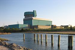
Sited in East Shoreham, the Shoreham Nuclear Power Plant was approved for Shoreham in 1973, but it was later decommissioned as the result of public protest. The builder, Long Island Lighting Company (LILCO), was partially reimbursed for money spent on construction. [3] The municipal bonds that were floated to reimburse the builder are being paid off by a special levy on the electric bills of residents of Long Island. [4] In 2022, estimates calculated the debt had grown from just under $8 billion to over $9 billion – more than $8,000 per ratepayer. [5]

Geography

East Shoreham is located on the North Shore of Long Island, by Long Island Sound. It is approximately 100 km (70 miles) from New York City. According to the United States Census Bureau, the CDP has a total area of 13.9 square kilometres (5.4 sq mi), all land. East Shoreham and the adjoining village of Shoreham share a post office, which has 11786 as the zip code. Despite its official name, East Shoreham is invariably referred to by its inhabitants as "Shoreham", while the adjoining village is often called "Shoreham Village".

East Shoreham is bordered to the east by Wading River in the town of Riverhead, to the south by Ridge, to the southwest by Rocky Point, to the west by the village of Shoreham.

Demographics

At the 2020 census, [6] there were 6,841 people in 2,023 households inside of the CDP. The population density was 1,267.1 inhabitants per square mile (489.2/km2). There were 1,934 housing units at an average density of 357.6 per square mile (138.1/km2). The racial makeup of the CDP was 88.6% White, 3.5% African American, 0.13% Native American, 3.4% Asian, 0.06% Pacific Islander, 3.23% from other races, and 3.6% from two or more races. Hispanic or Latino of any race were 10.2% of the population.

There were 1,787 households, of which 48.2% had children under the age of 18 living with them, 78.6% were married couples living together, 7.8% had a female householder with no husband present, and 11.1% were non-families. 9.0% of all households were made up of individuals, and 3.1% had someone living alone who was 65 years of age or older. The average household size was 3.20 and the average family size was 3.40.

29.9% of the population were under the age of 18, 7.0% from 18 to 24, 27.6% from 25 to 44, 28.0% from 45 to 64, and 7.5% who were 65 years of age or older. The median age was 37 years. For every 100 females, there were 100.0 males. For every 100 females age 18 and over, there were 95.9 males.

The median income was $85,916 and the median family income was $88,020. Males had a median income of $61,359 and females $35,536. The per capita income was $29,485. About 3.4% of families and 4.1% of the population were below the poverty threshold, including 2.3% of those under age 18 and 8.4% of those age 65 or over.

Education

The Josiah Woodhull house, built in 1720, is the oldest house in the Shoreham area and was undergoing renovation in 2014 Josiah Woodhull House.JPG
The Josiah Woodhull house, built in 1720, is the oldest house in the Shoreham area and was undergoing renovation in 2014

Shoreham, East Shoreham and the neighboring hamlet of Wading River form the Shoreham-Wading River School District.

Related Research Articles

Long Lake is an unincorporated community and census-designated place (CDP) in Lake County, Illinois, United States. Per the 2020 census, the population was 3,663.

<span class="mw-page-title-main">Wade, Mississippi</span> Census-designated place in Mississippi, United States

Wade is an unincorporated community and census-designated place (CDP) in Jackson County, Mississippi, United States. It is part of the Pascagoula Metropolitan Statistical Area. The population was 1,074 at the 2010 census, up from 491 at the 2000 census.

<span class="mw-page-title-main">Bellerose Terrace, New York</span> Hamlet and census-designated place in New York, United States

Bellerose Terrace is a hamlet and census-designated place (CDP) in the Town of Hempstead in Nassau County, on Long Island, in New York, United States. The population was 2,329 at the 2020 census.

<span class="mw-page-title-main">East Atlantic Beach, New York</span> Hamlet and census-designated place in New York, United States

East Atlantic Beach is a hamlet and census-designated place (CDP) in Nassau County, New York, United States. The population was 2,049 at the 2010 census. The unincorporated hamlet is governed by the Town of Hempstead, one of three towns in Nassau County.

<span class="mw-page-title-main">East Norwich, New York</span> Hamlet and census-designated place in New York, United States

East Norwich is a hamlet and census-designated place (CDP) located within the Town of Oyster Bay in Nassau County, on the North Shore of Long Island, in New York, United States. The population was 2,792 at the time of the 2020 census.

<span class="mw-page-title-main">Garden City Park, New York</span> Hamlet and census-designated place in New York, United States

Garden City Park is a hamlet and census-designated place (CDP) located in the Town of North Hempstead in Nassau County, on Long Island, in New York, United States. The population was 7,806 at the 2010 census.

<span class="mw-page-title-main">Harbor Isle, New York</span> Hamlet and census-designated place in New York, United States

Harbor Isle is a hamlet and census-designated place (CDP) in the Town of Hempstead in Nassau County, New York, United States. The population was 1,301 at the 2010 census.

<span class="mw-page-title-main">South Hempstead, New York</span> Hamlet and census-designated place in New York, United States

South Hempstead is a hamlet and census-designated place (CDP) in the Town of Hempstead in Nassau County, on Long Island, in New York, United States. The population was 3,406 at the time of the 2020 census.

<span class="mw-page-title-main">Uniondale, New York</span> Hamlet and census-designated place in New York, United States

Uniondale is a hamlet and census-designated place in Nassau County, New York, on Long Island, in the town of Hempstead. The population was 32,473 at the 2020 United States Census. Uniondale is home to Hofstra University's north campus, as well as a portion of its southern campus.

<span class="mw-page-title-main">Woodbury, Nassau County, New York</span> Hamlet and census-designated place in New York, United States

Woodbury is a hamlet and census-designated place (CDP) located within the Town of Oyster Bay in Nassau County, on Long Island, in New York, United States. The population was 9,335 at the 2020 census.

<span class="mw-page-title-main">Centereach, New York</span> Hamlet and census-designated place in New York, United States

Centereach is a hamlet and census-designated place in Suffolk County, New York, United States. The population was 31,578 at the 2010 census.

<span class="mw-page-title-main">East Quogue, New York</span> Hamlet and census-designated place in New York, United States

East Quogue is a hamlet and census-designated place (CDP) in the Town of Southampton in Suffolk County, on Long Island, in New York, United States. The population was 4,757 at the 2010 census.

<span class="mw-page-title-main">Medford, New York</span> Hamlet & census-designated place in New York, United States

Medford is a hamlet and census-designated place (CDP) in the Town of Brookhaven in Suffolk County, on Long Island, in New York, United States. The population was 24,247 at the 2020 census.

<span class="mw-page-title-main">Northville, Suffolk County, New York</span> Place in New York, United States

Northville is a hamlet and census-designated place (CDP) in the Town of Riverhead in Suffolk County, on Long Island, in New York, United States. The CDP population was 1,340 at the 2010 census. Between 1921 and 1930, it was an incorporated village known originally as the Incorporated Village of Sound Avenue, and from 1927 to 1930 as the Incorporated Village of Northville.

<span class="mw-page-title-main">Shoreham, New York</span> Village in New York, United States

Shoreham is an incorporated village in the Town of Brookhaven, Suffolk County, New York, United States. The population was 531 at the 2010 census. It is officially known as the Incorporated Village of Shoreham.

<span class="mw-page-title-main">Wading River, New York</span> Hamlet and census-designated place in New York, United States

Wading River is a hamlet and census-designated place (CDP) in Suffolk County, New York, United States, on the North Shore of Long Island. As of the 2010 census, the CDP population was 7,719. It is adjacent to Shoreham and shares a school district.

<span class="mw-page-title-main">Wainscott, New York</span> Hamlet and census-designated place in New York, United States

Wainscott is a hamlet in the Town of East Hampton in Suffolk County, New York, United States, on the South Fork of Long Island. As of the 2010 United States Census, the CDP population was 650. For statistical purposes, the United States Census Bureau defined a census-designated place (CDP) for the 2000 census that roughly corresponds to the same area.

<span class="mw-page-title-main">Hope Valley, Rhode Island</span> Census-designated place in Rhode Island, United States

Hope Valley is a village and census-designated place (CDP) in the town of Hopkinton, Rhode Island, United States. The population of the CDP was 1,612 at the 2010 census. Hope Valley is the largest village in Hopkinton, and the town's principal commercial center. While the village of Hope Valley is located in Hopkinton, its zip code, 02832, extends into the neighboring town of Richmond.

<span class="mw-page-title-main">Mount Gay-Shamrock, West Virginia</span> Census-designated place in West Virginia, United States

Mount Gay-Shamrock is a census-designated place (CDP) in Logan County, West Virginia, United States.

<span class="mw-page-title-main">Gulfport–Biloxi metropolitan area</span> Metropolitan statistical area in Mississippi, US

The Gulfport-Biloxi Metropolitan Statistical Area is a metropolitan statistical area (MSA) in the Mississippi Gulf Coast region that includes four counties – Hancock, Harrison, Jackson and Stone. The principal cities are Gulfport and Biloxi. The 2010 census placed the Gulfport-Biloxi MSA population at 388,488, though as of 2019, it was estimated to have increased to 417,665. The area was significantly impacted by Hurricane Katrina on August 29, 2005, and prior to the hurricane, had experienced steady to moderate population growth. However, growth has since rebounded, with the population steadily increasing every year throughout the 2010s.

References

  1. "ArcGIS REST Services Directory". United States Census Bureau. Retrieved September 20, 2022.
  2. "U.S. Census Bureau QuickFacts".
  3. "LIPA may acquire LILCO". CNN. Retrieved March 31, 2024.
  4. "Refinancing of Long Island Lighting Company". The Connecticut General Assembly, OFFICE OF LEGISLATIVE RESEARCH. Retrieved March 31, 2024.
  5. "Municipalized LIPA Won't Solve Long Islanders' Power Woes". The Empire Center. Retrieved March 31, 2024.
  6. "U.S. Census website". United States Census Bureau . Retrieved January 31, 2008.