Davis Park, New York

Last updated

Davis Park
Davis Park Dockmaster Tower.jpg
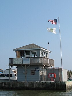
Davis Park Dockmaster Tower, Ferry Port and Marina
USA New York location map.svg
Red pog.svg
Davis Park
Location within the state of New York
Coordinates: 40°41′1.7″N73°0′19.1″W / 40.683806°N 73.005306°W / 40.683806; -73.005306
Country United States
State New York
County Suffolk
Time zone UTC−05:00 (Eastern Time Zone)
  Summer (DST) UTC−04:00
ZIP Code
11772
Area code(s) 631, 934
GNIS feature ID948069 [1]

Davis Park is a hamlet in the Town of Brookhaven, Suffolk County, New York, United States. It is located on Fire Island, a barrier island separated from the southern side of Long Island by the Great South Bay off the South Shore village of Patchogue. It lies within the Fire Island National Seashore.

Contents

Davis Park is a Fire Island beach community which acts as a destination for families and singles alike, who are home owners, renters, boaters, and ferry goers.

Davis Park is commonly used to refer to three contiguous areas in the hamlet of Davis Park, namely, Davis Park, Leja Beach, and Ocean Ridge. The three areas share services and social life, and are separated from other communities on Fire Island.

Technically, Davis Park refers to the business and public part of the community on both sides of Trustees' Walk, in contrast to the sections known as Leja Beach (to the west of Trustees Walk bounding Center Walk to the North and South) and Ocean Ridge (to the east).

Davis Park is the easternmost private community on Fire Island (formerly, there were other communities to the east that were removed by the National Park Service after the creation of Fire Island National Seashore in 1964, they included Bayberry Dunes, [2] Whalehouse Point [3] and Long Cove [4] ).

The community extends along approximately34 mile (1.2 km) of beachfront, and is approximately 330 yards (0.30 km) wide at its widest and 190 yards (0.17 km) wide at its narrowest point (dune to bay, excluding ocean beach width). Davis Park is bordered by extensive wilderness areas to both east and west. The Watch Hill facility of the National Park Service (with a small marina, restaurant, campground, nature trail and seasonal tours and activities) is approximately 12 mile (0.80 km) east, and Water Island (a community, not a separate island) is approximately one mile (1.6 km) to the west. Davis Park lies approximately 13.9 miles (22.4 km) from the eastern end of Fire Island at Moriches Inlet and 16.3 miles (26.2 km) from the western end of Fire Island at Democrat Point (in Robert Moses State Park).

The United States Post Office at Davis Park (open July and August only) lies at approximately 40°41′04″N73°00′15″W / 40.68444°N 73.00417°W / 40.68444; -73.00417 .

To reach Davis Park, one must travel by boat. A ferry (seasonal, mid-March to end of November) is available which departs from Sandspit Park in Patchogue on the mainland of Long Island and travels approximately for 15–20 minutes across the Great South Bay.

Davis Park has approximately 350 homes (130 in Ocean Ridge and 220 in Davis Park), one general store and grill, one restaurant and one bar. The restaurant and bar are the only ones on Fire Island with a clear view of the bay and the ocean. There is one unpaved road, commonly called the Burma Road, and wooden boardwalks. There are no cars (except for emergency, utility and construction vehicles and a very limited number of private vehicles, which are only allowed through a strict permit process regulated by the National Park Service). There are no street lights except in the marina area, resulting in fine night time star-gazing. There are, a Brookhaven town public marina, a (seasonally) lifeguarded section of beach and public restrooms and showers.

Davis Park is protected by the all-volunteer Davis Park Fire Department and by Suffolk County Police. The non-for-profit Davis Park Medical Association owns a house, "Bedside Manor," on the dune in Ocean Ridge, which is rented in season to doctors and nurse practitioners at a below-market rate in exchange for their agreement to provide basic medical services through scheduled office hours and on-call availability. Bedside Manor is equipped with basic medical equipment and supplies. A helipad provides emergency evacuation capability.

History

The origins of Davis Park can be tracked back to the 1940s. It all started with Mr. Davis of Blue Point who owned a tract of land of Fire Island. When he passed away he left some of the land to his sons. One of those sons sold his share of the land to four friends (Lee Coffin, Ed Shembler, Joe Gerard, and Al Brown) who would later go on to build the Davis Park Casino. [ citation needed ] The first letters of their first names were used to create the name of LEJA Beach.

2009 Beach Renourishment

In the winter and spring of 2009, a beach renourishment project was undertaken on Fire Island, with the cooperation of the National Park Service, the U.S. Army Corps of Engineers, the towns of Brookhaven and Islip and Fire Island residents. The renourishment program involved dredging sand from an offshore borrow area, pumping it onto the beach and shaping the sand into an approved beach face and dune template in front of the communities of Davis Park, Corneille Estates, Dunewood, Fair Harbor, Fire Island Pines, Fire Island Summer Club, Lonelyville, Ocean Bay Park, Ocean Beach, Saltaire, and Seaview. Fire Islanders agreed to a significant property tax increase to help pay for the project, which was estimated to cost between $23 and $25 million, including the cost of environmental monitoring, and was expected to add 1.8 million cubic yards of sand in front of the participating communities. The towns of Brookhaven and Islip, in which the communities are located, issued bonds to pay for the project, backed by the new taxes levied by community Erosion Control Taxing Districts. Fire Island has been named by the American Shore and Beach Preservation Association [5] a winner of its 2009 Best Restored Beach award.

In November 2009, the remnants of Hurricane Ida, by then nicknamed the "nor' Ida," did substantial damage to the beachfront in Davis Park, carrying away much of the sand of the previous spring's beach renourishment project. New York Governor David A. Paterson asked President Barack Obama to declare a major federal disaster for the counties of Nassau, Queens and Suffolk (including Fire Island) for the severe erosion and damage to the protective barrier beaches.

Tourism

See also

Related Research Articles

<span class="mw-page-title-main">Bellport, New York</span> Village in New York, United States

Bellport is a village in the Town of Brookhaven in Suffolk County, on the South Shore of Long Island, in New York, United States. The population was 2,084 at the 2010 census.

<span class="mw-page-title-main">East Patchogue, New York</span> Census-designated place in New York, United States

East Patchogue is a census-designated place (CDP) in the Town of Brookhaven in Suffolk County, on the South Shore of Long Island, in New York, United States. The population was 22,469 at the 2010 census. The CDP is a proximate representation of the East Patchogue hamlet used for statistical purposes of the Census Bureau.

<span class="mw-page-title-main">Cherry Grove, New York</span> Hamlet in New York, United States

Cherry Grove is a hamlet in the Town of Brookhaven, Suffolk County, New York, United States. It is located on Fire Island, a barrier island separated from the southern side of Long Island by the Great South Bay. The hamlet has approximately 300 houses on 41 acres (170,000 m2), a summer seasonal population of 2,000 and a year-round population of 15.

<span class="mw-page-title-main">Patchogue, New York</span> Village in New York, United States

Patchogue is a village in Suffolk County, New York. The population was 12,408 at the time of the 2020 census. Patchogue is an incorporated community part of the town of Brookhaven, on the south shore of Long Island, adjoining the Great South Bay. It is officially known as the Incorporated Village of Patchogue.

<span class="mw-page-title-main">Brookhaven, New York</span> 2nd most populated town in New York, United States

Brookhaven, formally the Town of Brookhaven, is a large suburban town in Suffolk County, Long Island, New York. With a population of 488,497 as of 2022, it is the second most populous town in the United States and in New York and the third most populous community in the state.

<span class="mw-page-title-main">Fire Island</span> Island in New York

Fire Island is the large center island of the outer barrier islands parallel to the South Shore of Long Island in the U.S. state of New York.

<span class="mw-page-title-main">Fire Island National Seashore</span> National park system unit in New York, United States

Fire Island National Seashore (FINS) is a United States National Seashore that protects a 26-mile (42 km) section of Fire Island, an approximately 30-mile (48 km) long and 0.5-mile (0.80 km) wide barrier island separated from Long Island by the Great South Bay. The island is part of New York State's Suffolk County and the Outer Barrier.

<span class="mw-page-title-main">Fire Island Pines, New York</span> Hamlet in New York, United States

Fire Island Pines is a hamlet in the Town of Brookhaven, Suffolk County, New York, United States. It is located on Fire Island, a barrier island separated from the southern side of Long Island by the Great South Bay.

<span class="mw-page-title-main">Outer Barrier</span> String of barrier islands dividing Long Island from the Atlantic Ocean

The Outer Barrier, also known as the Long Island and New York City barrier islands, refers to the string of barrier islands that divide the lagoons south of Long Island, New York from the Atlantic Ocean. These islands include Long Beach Barrier Island, Barnum Island, Jones Beach Island, Fire Island and Westhampton Island. The outer barrier extends 75 miles (121 km) along the South Shore of Long Island, from the Rockaway Peninsula in New York City to the east end of Shinnecock Bay in Suffolk County.

Ocean Bay Park is a hamlet in the town of Brookhaven in Suffolk County, New York, United States. It is located on Fire Island, a barrier island separated from the southern side of Long Island by the Great South Bay. To reach Ocean Bay Park, one must take a ferry or water taxi from Bay Shore.

<span class="mw-page-title-main">Patchogue station</span> Long Island Rail Road station in Suffolk County, New York

Patchogue is a station of the Montauk Branch of the Long Island Rail Road in Patchogue, New York. It is on Division Street between West Avenue and South Ocean Avenue. The station is the eastern terminus for some trains on the branch.

<span class="mw-page-title-main">Clearwater Beach</span> Beach in Pinellas County, Florida

Clearwater Beach includes a resort area and a residential area on a barrier island in the Gulf of Mexico in Pinellas County on the west-central coast of Florida. Located just west over the Intracoastal Waterway by way of the Clearwater Memorial Causeway from the rest of the city of Clearwater, Florida, of which it is part, Clearwater Beach is at a geographic latitude of 27.57 N and longitude 82.48 W.

<span class="mw-page-title-main">Patchogue Bay</span> Bay on Long Island, New York

Patchogue Bay is a lagoon on the south-central shores of Long Island in the U.S. state of New York.

<span class="mw-page-title-main">Watch Hill (New York)</span> Camground and marina on Fire Island, New York

Watch Hill is a campground and marina located on Fire Island, a barrier island off the south shore of New York's Long Island. The park is located across the Great South Bay from Patchogue and is contained within the Fire Island National Seashore.

<span class="mw-page-title-main">Sandspit Park Beach & Marina</span>

Sandspit Park Beach & Marina is located on the Patchogue River in the Village of Patchogue in Suffolk County, New York.

<span class="mw-page-title-main">Patchogue River</span>

The Patchogue River is a mile-long waterway In Patchogue, New York that is lined with a variety of restaurants, marinas, fueling docks, apartment condominiums, and ferry terminals.

<span class="mw-page-title-main">Cupsogue Beach County Park</span>

Cupsogue Beach County Park is a 296-acre (1.20 km2) park at the eastern end of Fire Island and the western end of Westhampton Island, known locally as Dune Road, one of Long Island's easternmost barrier islands. The Atlantic Ocean, Moriches Inlet and Moriches Bay surround the park.

<span class="mw-page-title-main">American Shore and Beach Preservation Association</span> Non-profit organization

The American Shore and Beach Preservation Association (ASBPA) is a private, nonprofit organization formed in 1926. It was founded to address coastal erosion and the loss of sand on America's beaches. Today, ASBPA is an association of beach and coastal practitioners, including beach towns and managers, coastal engineers, coastal geologists, dredging and ecological restoration companies, coastal academics and students. ASBPA advances coastal science and coastal engineering through its peer-reviewed journal, Shore & Beach, and an annual technical conference. It also hosts an annual coastal summit in Washington, DC to advocate for coastal policies.

References

  1. "Davis Park, New York". Geographic Names Information System . United States Geological Survey, United States Department of the Interior.
  2. Lipson, Eden (September 5, 1976). "Bayberry Dunes, 1963‐1976. R.I.P." The New York Times . p. 239. Retrieved August 25, 2021.
  3. Weissmann, Richard (August 7, 1983). "THE OTHER FIRE ISLAND: A PLACE FROZEN IN TIME". The New York Times. p. 1 Section 11LI. Retrieved August 25, 2021.
  4. Kennedy, Shawn G. (July 13, 1978). "Fire Island Squatters. Fighting Eviction". The New York Times. p. 1 Section B. Retrieved August 25, 2021.
  5. "ASBPA". www.asbpa.org.


Preceded by Beaches of Fire Island Succeeded by