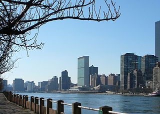
The East River is a saltwater tidal estuary or strait in New York City. The waterway, which is actually not a river despite its name, connects Upper New York Bay on its south end to Long Island Sound on its north end. It separates Long Island, with the boroughs of Brooklyn and Queens, from Manhattan Island, and from the Bronx on the North American mainland.
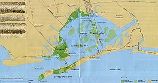
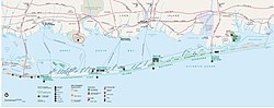
Jamaica Bay is an estuary on the southern portion of the western tip of Long Island, in the U.S. state of New York. The estuary is partially man-made, and partially natural. The bay connects with Lower New York Bay to the west, through Rockaway Inlet, and is the westernmost of the coastal lagoons on the south shore of Long Island. Politically, it is primarily divided between the boroughs of Brooklyn and Queens in New York City, with a small part touching Nassau County.

The Jersey Shore, commonly referred to locally as simply the Shore, is the coastal region of the U.S. state of New Jersey. Geographically, the term encompasses about 141 miles (227 km) of oceanfront bordering the Atlantic Ocean, from Perth Amboy in the north to Cape May Point in the south. The region includes Middlesex, Monmouth, Ocean, Atlantic, and Cape May counties, which are in the central and southern parts of the state. Located in the center of the Northeast Megalopolis, the northern half of the shore region is part of the New York metro area, while the southern half of the shore region is part of the Philadelphia metro area. The Jersey Shore hosts the highest concentration of oceanside boardwalks in the United States.
Barren Island is a peninsula and former island on the southeast shore of Brooklyn in New York City. Located on Jamaica Bay, it was geographically part of the Outer Barrier island group on the South Shore of Long Island. The island was occupied by the Lenape Native Americans prior to the arrival of Dutch settlers in the 17th century. Its name is a corruption of Beeren Eylandt, the Dutch-language term for "Bears' Island".

Midland Beach is a neighborhood of Staten Island in New York City. It lies along the east-central coast of the island, in the area known locally as the "Mid-Island, Staten Island" or the "East Shore".

Fire Island is the large center island of the outer barrier islands parallel to the South Shore of Long Island in the U.S. state of New York.

Canarsie is a mostly residential neighborhood in the southeastern portion of Brooklyn, New York City. Canarsie is bordered on the east by Fresh Creek Basin, East 108th Street, and Louisiana Avenue; on the north by Linden Boulevard; on the west by Ralph Avenue; on the southwest by Paerdegat Basin; and on the south by Jamaica Bay. It is adjacent to the neighborhoods of East Flatbush to the west, Flatlands and Bergen Beach to the southwest, Starrett City to the east, East New York to the northeast, and Brownsville to the north.

Gerritsen Beach is a neighborhood in the New York City borough of Brooklyn, located between Sheepshead Bay to the west and Marine Park to the east. The area is served by Brooklyn Community Board 15. The population of the neighborhood is 4,797 as of the 2020 U.S. census.

Sheepshead Bay is a neighborhood in southern Brooklyn, New York City. It is bounded by Ocean Parkway to the west; Avenue T and Kings Highway to the north; Nostrand Avenue and Gerritsen Avenue to the east; and the Atlantic Ocean to the south. Sheepshead Bay is abutted by the neighborhoods of Brighton Beach and Homecrest to the west; Midwood to the north; and Gerritsen Beach to the east.
Mill Basin is a residential neighborhood in southeastern Brooklyn, New York City. It is on a peninsula abutting Jamaica Bay and is bordered by Avenue U on the northwest and the Mill Basin/Mill Island Inlet on its remaining sides. Mill Basin is adjacent to the neighborhood of Bergen Beach to the northeast, Flatlands to the northwest, Marine Park to the southwest, and Floyd Bennett Field and the former Barren Island to the southeast. Mill Basin also contains a subsection called Old Mill Basin, north of Avenue U.

Davis Park is a hamlet in the Town of Brookhaven, Suffolk County, New York, United States. It is located on Fire Island, a barrier island separated from the southern side of Long Island by the Great South Bay off the South Shore village of Patchogue. It lies within the Fire Island National Seashore.
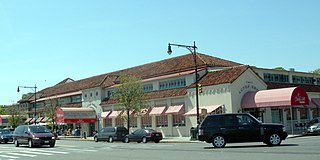
Lundy's Restaurant, also known as Lundy Brothers Restaurant, was an American seafood restaurant in the Sheepshead Bay neighborhood of Brooklyn in New York City, along the bay of the same name. Lundy's was founded in 1926 by Irving Lundy as a restaurant on the waterfront of Sheepshead Bay; five years later, the original building was condemned to make way for a redevelopment of the bay. The present building opened in 1934 or 1935, and closed in 1979. Another restaurant operated in the Lundy's building from 1996 to early 2007, after which the building was converted into a shopping center.

Fair Harbor is a small community hamlet located near the western end of Fire Island. It is a part of the Town of Islip on Long Island, New York. With approximately 350 homes within its 13-block town limits, the town features a few stores and other amenities, giving it old-style charm with the security of a state-of-the-art Fire Department and EMS. Moreover, the small town is mere steps away from the easily accessible beach, and the bay front is incredibly active during the summer months.
Bergen Beach is a residential neighborhood in the borough of Brooklyn, New York City. It is located on a peninsula abutting Jamaica Bay in the southeastern portion of the borough, and is bordered by Mill Basin and the neighborhood of the same name to the south and west; the neighborhood of Flatlands to the northwest; Paerdegat Basin and the neighborhood of Canarsie to the northeast; and Jamaica Bay and the Belt Parkway to the east. Bergen Beach contains a sub-neighborhood named Georgetown. The vast majority of residents are white, and the neighborhood generally has a suburban quality.

The Riegelmann Boardwalk is a 2.7-mile-long (4.3 km) boardwalk on the southern shore of the Coney Island peninsula in Brooklyn, New York City, United States. Opened in 1923, the boardwalk runs along the Atlantic Ocean between West 37th Street to the west, at the edge of the Sea Gate neighborhood, and Brighton 15th Street to the east, in Brighton Beach. It is operated by the New York City Department of Parks and Recreation.

Industry City is a historic intermodal shipping, warehousing, and manufacturing complex on the Upper New York Bay waterfront in the Sunset Park neighborhood of Brooklyn, New York City. The northern portion, commonly called "Industry City" on its own, hosts commercial light manufacturing tenants across 6,000,000 square feet (560,000 m2) of space between 32nd and 41st Streets, and is operated by a private consortium. The southern portion, known as "Bush Terminal", is located between 40th and 51st Streets and is operated by the New York City Economic Development Corporation (NYCEDC) as a garment manufacturing complex.

The Brooklyn Navy Yard is a shipyard and industrial complex in northwest Brooklyn in New York City, New York, U.S. The Navy Yard is located on the East River in Wallabout Bay, a semicircular bend of the river across from Corlears Hook in Manhattan. It is bounded by Navy Street to the west, Flushing Avenue to the south, Kent Avenue to the east, and the East River on the north. The site, which covers 225.15 acres (91.11 ha), is listed on the National Register of Historic Places.

The South Beach–Franklin Delano Roosevelt Boardwalk, alternately referred to as the FDR Boardwalk or the South Beach Boardwalk, is a boardwalk facing the Lower New York Bay on the East Shore of Staten Island, one of the five boroughs of New York City. The boardwalk is the main feature of a public park that stretches from Fort Wadsworth and the Verrazzano-Narrows Bridge to Miller Field, both part of the Gateway National Recreation Area. The park also contains numerous recreational facilities, including a skate park.
Edgemere Landfill is a former municipal landfill located in Edgemere on the Rockaway peninsula in Queens, New York City. It is located on a man-made peninsula on the Jamaica Bay shoreline, at the eastern end of the Rockaway peninsula. A portion of the site is open to the public as Rockaway Community Park. The entire site is owned by the New York City Department of Parks and Recreation.
William Jones Youngs was an American lawyer and politician from New York.