Fair Harbor | |
---|---|
Coordinates: 40°38′21″N73°11′5″W / 40.63917°N 73.18472°W Coordinates: 40°38′21″N73°11′5″W / 40.63917°N 73.18472°W | |
Country | United States |
State | New York |
County | Suffolk |
Township | Islip |
Time zone | UTC-5 (EST) |
• Summer (DST) | UTC-4 (EDT) |
ZIP code | 11706 |
Area code(s) | 631 |
Fair Harbor is a small community hamlet located near the western end of Fire Island. [1] It is a part of the Town of Islip on Long Island, New York. [2] With approximately 350 homes within its 13-block town limits, [3] the town features a few stores, a restaurant and a pizza shop, [4] giving it old-style charm with the security of a state-of-the-art Fire Department and EMS. Moreover, the beach is wide, and the bay front is active. [5]
The community was first founded in the late 1800s. [6] A few of Fair Harbor's 350 houses date to the 1920s, but most were built in the 1970s and many have been built recently. [5]
Fair Harbor—like most other Fire Island communities—is mainly a summer community, although a few families choose to live there year-round. Many of the homes have been passed down from generation to generation. The town has a strong summer rental market, with most houses renting for the entire summer season or by the month. During the off-season there is limited car access to Fire Island while during the summer there is no car access and the town can only be reached by ferry [7] or private boat. Biking and walking are the main modes of transportation. Fair Harbor falls under the police jurisdiction of Suffolk County Marine Bureau and is protected by its own volunteer fire department, the Fair Harbor Fire Department, founded in 1931. During the summer months lifeguards are stationed on both the bay beach and ocean beach.
Children of the year-round families attend the Fire Island School District in Corneille Estates until grade 6, [8] at which point they are bussed to public or parochial schools in Bay Shore or Islip for grades 7–12. The neighboring communities of Dunewood and Lonelyville, to the east have no stores or services so they rely on many of Fair Harbor's services, such as the Fire Department and EMS [9] and Fair Harbor's one grocery store, hardware emporium, liquor store and restaurant. The population in the summer swells to about 1,500. [6]
Fair Harbor is famous for its annual Pine Walk Arts and Crafts Fair, a Fire Island favorite, which was established in 1972. [10] It adds to this community's bohemian beach vibe while still being an intimate family community where neighbors congregate at the bay to watch the sunsets. Some 400 modest yet gracious beach houses adorn the narrow residential walks. There are no hotels or B&B's in Fair Harbor, but they do have a thriving real estate agent industry and house rentals are readily available. Fair Harbor also has its own direct ferry line out of Bay Shore and private community marina. [11]
Being a seasonal community, Fair Harbor offers only a few services. The Pioneer Market [12] is the only grocer in the hamlet; Le Dock, the only restaurant, is open for lunch and dinner and offers both indoor and outdoor dining. The Loading Dock sells liquor and wine, and Corliss on the Bay sells miscellaneous items including bikes, souvenirs, hardware, toys, magazines, books, paint, and garden items. There is also an ice cream store and a pizza take-out shop. [13] These stores are open 7 days a week in season and closed during the off season (October through May). [6] There is also the Fair Harbor Clothing store, established by individuals who grew up a block away from Fair Harbor "in a barefoot community," developing a "deep appreciation for the water, waves and bounty of the sea." [14]
Fair Harbor is located on the western part of Fire Island between the Great South Bay and the Atlantic Ocean. It is about 47 miles by car to the ferry dock in Bay Shore, NY. From there, it is six miles by ferry across the water to Fair Harbor. [15] Saltaire is the incorporated village immediately west of Fair Harbor while Dunewood and Lonelyville are directly to the east. To get to Fair Harbor, it is necessary to take the ferry from Bay Shore. [7]
While there are no hospitals or clinics in the town, medical service is provided in the summer months by the Fair Harbor Medical District. The district hires doctors, on one week intervals, from Memorial Day through Labor Day. The district provides a walk-in doctor's office and doctor's residence. The doctors are not paid but get a free week at the beach, are allowed to keep modest fees from patients and have office hours two hours a day—from 11 to Noon and 5 to 6 PM. For medical emergencies, the Fair Harbor Fire Department provides emergency medical services (EMS) which transports patients by its ambulance or by Suffolk County Police boat to Good Samaritan or Southside hospitals on the mainland, or by SCPD helicopter. [6]
Edgartown is a tourist destination on the island of Martha's Vineyard in Dukes County, Massachusetts, United States, for which it is the county seat.
Bay Shore is a hamlet and census-designated place (CDP) in the Town of Islip, Suffolk County, New York, United States. It is situated on the South Shore of Long Island, adjoining the Great South Bay. In 2008, Bay Shore celebrated the 300th anniversary of the purchase of the land from the Secatogue Native Americans. The population of the CDP was 26,337 at the time of the 2010 census.
Cherry Grove is a hamlet in the Town of Brookhaven, Suffolk County, New York, United States. It is located on Fire Island, a barrier island separated from the southern side of Long Island by the Great South Bay. The hamlet has approximately 300 houses on 41 acres (170,000 m2), a summer seasonal population of 2,000 and a year-round population of 15.
Saltaire is a village on Fire Island in the southern part of the Town of Islip in Suffolk County, New York, United States. The year-round population was 37 at the 2010 census, which, as a summer beach community, increases many times over in the summer.
Islip is one of ten towns in Suffolk County, New York (USA). Located on the South Shore of Long Island, the town population was 335,543 at the 2010 census. Within the Town of Islip is a smaller, unincorporated hamlet and census-designated place also named Islip.
The Jersey Shore is the coastal region of the U.S. state of New Jersey. Geographically, the term encompasses about 141 miles (227 km) of oceanfront bordering the Atlantic Ocean, from Perth Amboy in the north to Cape May Point in the south. The region includes Middlesex, Monmouth, Ocean, Atlantic, and Cape May counties. Many New Jersey residents refer to it simply as The Shore. Most of the shore region is located in Central and South New Jersey.
Islip is a hamlet and census-designated place (CDP) that lies within the much larger Town of Islip in Suffolk County, New York. Located on the South Shore of Long Island, the CDP had a population of 18,869 at the time of the 2010 census, a decline of 8% from the 2000 census.
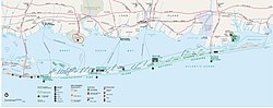
Fire Island is the large center island of the outer barrier islands parallel to the south shore of Long Island, New York. Occasionally, the name is used to refer collectively to not only the central island, but also Long Beach Barrier Island, Jones Beach Island, and Westhampton Island, since the straits which separate these islands are ephemeral. In 2012, Hurricane Sandy once again divided Fire Island into two islands. Together, these two islands are approximately 31 miles (50 km) long and vary between 520 and 1,310 feet wide. Fire Island is part of Suffolk County. It lies within the towns of Babylon, Islip, and Brookhaven, containing two villages and a number of hamlets. All parts of the island not within village limits are part of the Fire Island census-designated place (CDP), which had a permanent population of 292 at the 2010 census, though that expands to thousands of residents and tourists during the summer months.
Two Harbors, colloquially known as "The Isthmus", is a small unincorporated community island village on Santa Catalina Island, California, with a population of 298. It is the second center of population on the island, besides the city of Avalon. It is mainly a resort village. It has only one restaurant, one hotel and one general store. The village has about 150 permanent residents who live on the isthmus year-round. One notable feature was the one-room schoolhouse which closed in 2014.
The South Shore of Long Island, in the U.S. state of New York, is the area along Long Island's Atlantic Ocean shoreline. Though some consider the South Shore to include parts of Queens, particularly the beach communities in the Rockaways such as Belle Harbor, the term is generally used to refer to the Long Island coastline in Nassau and Suffolk counties. It is often used as a generic name for the entire southern half of Long Island rather than just the area immediately adjacent to the coastline.
Davis Park is a hamlet on Fire Island in the Town of Brookhaven in Suffolk County, in the U.S. state of New York, off the South Shore village of Patchogue, Long Island. It lies within the Fire Island National Seashore. Davis Park is commonly used to refer to the business and public part of the community on both sides of Trustees' Walk, in contrast to the sections known as Leja Beach and Ocean Ridge. However, Davis Park is also used to refer to all three areas together, which are contiguous, share services and social life, and are separated from other communities on the island.
Ocean Bay Park is a hamlet in the Town of Brookhaven in Suffolk County, New York, on Fire Island.
Auke Bay is a neighborhood located in the city and borough of Juneau, Alaska, that contains Auke Bay Harbor, Auke Lake, the University of Alaska Southeast, an elementary school, a church, a post office, a bar, a coffee shop, a waffle house, a thrift shop, a Thai restaurant, and one convenience store. The view of the Mendenhall Glacier behind Auke Bay and Mount McGinnis towering over Auke Lake are some of the most popular photo opportunities in Juneau. The ferry terminal of the Alaska Marine Highway system is also located further out the road in Auke Bay at about 14 miles. The flamingo house on Auke Lake is a local attraction, known for its topical or weather-related formations of pink lawn flamingos. Whale watchings targeting curious humpbacks are available. Humpbacks in these areas are known to demonstrate special feeding methods, so-called "bubble-net feeding", and come very close to shores.
Dunewood is a small beach community in the western end of Fire Island, New York State. With about 100 homes originally all built on an identical floor plan, While the community specifically does not market itself to tourists and short-term renters, it is a popular location for long-term residents, and properties are rarely for sale. The community has only very limited facilities, and while during summertime, it shares a doctor with nearby Fair Harbor, during other times of the year, serious cases have to be medevaced by helicopter.
Lonelyville is a small, beach community located in the western end of Fire Island in the Town of Islip in Suffolk County, New York, United States.
Kismet is a hamlet in the town of Islip, Suffolk County, New York, United States. It is the westernmost beach community on Fire Island, immediately west of Saltaire and east of the Fire Island Light. Kismet is accessible by road or on foot via Robert Moses State Park to the west, or by ferry from Bay Shore on Long Island.
Bay Shore Post Office, the U.S. post office in Bay Shore, New York, is located at 10 Bay Shore Avenue just north of Main Street. It serves the ZIP code 11706, as well as Kismet, Saltaire, Dunewood, Fair Harbor, and Point O'Woods, on Fire Island.
![]() | Wikimedia Commons has media related to Fair Harbor, New York . |
Preceded by Dunewood | Beaches of Fire Island | Succeeded by Saltaire |