Brightwaters, New York

Last updated

Brightwaters, New York
Incorporated Village of Brightwaters
Brightwaters Village Hall; April 2019-3.jpg
Brightwaters Village Hall in April 2019.
Suffolk County, NY, towns and villages Brightwaters highlighted.svg
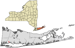
Location within Suffolk County.
USA New York location map.svg
Red pog.svg
Brightwaters, New York
Location within the state of New York.
Coordinates: 40°43′17″N73°15′57″W / 40.72139°N 73.26583°W / 40.72139; -73.26583
Country Flag of the United States.svg  United States
State Flag of New York.svg  New York
County Suffolk
Town Islip
IncorporatedNovember 30, 1916 [1]
Area
[2]
  Total0.99 sq mi (2.56 km2)
  Land0.97 sq mi (2.50 km2)
  Water0.02 sq mi (0.06 km2)
Elevation
23 ft (7 m)
Population
 (2020)
  Total3,181
  Density3,292.96/sq mi (1,271.92/km2)
Time zone UTC-5 (Eastern (EST))
  Summer (DST) UTC-4 (EDT)
ZIP code
11718
Area code 631
FIPS code 36-08323
GNIS feature ID0975774
Website www.villageofbrightwaters.com

Brightwaters is an incorporated village in the southwestern part of the Town of Islip in Suffolk County, on Long Island, in New York, United States. The population was 3,103 at the time of the 2010 census.

Contents

History

Brightwaters was developed in the early 20th Century by the T.B. Ackerson Company, which was known for its work in Brooklyn. [3] [4]

By 1916, locals felt that their community, which at the time was still an unincorporated part of the Town of Islip, would be better off if they were to incorporate as a village, citing concerns over how their community was being taxed and how they had to pay for private subscriptions for things which the believed should have been provided through taxes paid to Islip. [3] This led to locals signing a petition to incorporate Brightwaters as a village. The petition was given to the Town of Islip on September 20, 1916, and Brightwaters became an incorporated village on November 30, 1916. [3]

Geography

According to the United States Census Bureau, the village has a total area of 1.0 square mile (2.6 km2), of which 0.97 square miles (2.5 km2) is land and 0.04 square miles (0.1 km2), or 2.26%, is water. [5] [6]

It contains Wohseepee Park in northern Brightwaters, the Brightwaters Canal directly south of Montauk Highway, and four lakes directly north of Montauk Highway: Cascades Lake, Mirror Lake, Lagoon Lake and Nosrekca Lake. [3] The village's businesses are located at the intersection of Windsor Avenue and Orinoco Drive (referred to as Brightwaters Village). These geographic features make up the three districts of the village; the Canal District (southern Brightwaters, everything south of Montauk Highway), the Lakes District (central Brightwaters, everything north of the highway to Union Boulevard) and the Wohseepee Park District (northern Brightwaters, everything north of Union Boulevard to Seneca Drive).[ citation needed ]

Brightwaters uses the 11718 ZIP code, which is distinct from the Bay Shore Postal District (11706). [3]

Demographics

Historical population
CensusPop.Note
1920 250
1930 1,061324.4%
1940 1,56247.2%
1950 2,33649.6%
1960 3,19336.7%
1970 3,80819.3%
1980 3,286−13.7%
1990 3,265−0.6%
2000 3,248−0.5%
2010 3,103−4.5%
2020 3,1812.5%
U.S. Decennial Census [7]

2010 census

As of the census of 2010, there were 3,103 people residing in the village. [8] [9] The racial makeup of the village was 94.26% White, 1.51% African American, 1.61% Asian, 0.03% Native American, 0.87% from other races, and 1.71% from two or more races. Hispanic or Latino of any race were 5.12% of the population.

Census 2000

As of the census of 2000, there were 3,248 people, 1,127 households, and 912 families residing in the village. [8] The population density was 3,299.2 inhabitants per square mile (1,273.8/km2). There were 1,144 housing units at an average density of 1,162.0 per square mile (448.7/km2). The racial makeup of the village was 95.23% White, 1.57% African American, 0.06% Native American, 1.29% Asian, 0.06% Pacific Islander, 0.65% from other races, and 1.14% from two or more races. Hispanic or Latino of any race were 4.06% of the population.

There were 1,127 households, out of which 38.9% had children under the age of 18 living with them, 71.8% were married couples living together, 6.8% had a female householder with no husband present, and 19.0% were non-families. 14.6% of all households were made up of individuals, and 5.9% had someone living alone who was 65 years of age or older. The average household size was 2.87 and the average family size was 3.20.

In the village, the population was spread out, with 27.3% under the age of 18, 5.0% from 18 to 24, 28.8% from 25 to 44, 27.2% from 45 to 64, and 11.7% who were 65 years of age or older. The median age was 38 years. For every 100 females, there were 93.7 males. For every 100 females age 18 and over, there were 94.7 males.

The median income for a household in the village in 2016 was $146,892, and the median income for a family was $121,569 About 0.8% of families and 1.8% of the population were below the poverty line, including 0.7% of those under age 18 and none of those age 65 or over.

Parks and recreation

Parks in Brightwaters include: [3]

Government

As of July 2021, the Mayor of Brightwaters is John J. Valdini, and the Village Trustees are Mary Del Vecchio, Michael Dopsovic, Patrick Fawcett, and Thomas Zepf. [10]

In the 2021 U.S. presidential election, the majority of Brightwaters voters voted for Joe Biden (D). [11] [12]

Education

School district

Brightwaters residents are served by the Bay Shore Union Free School District. As such, all children who reside within Brightwaters and attend public schools go to Bay Shore's schools. [3] [13]

Library district

Brightwaters is located wholly within the boundaries of the Bay Shore–Brightwaters Public Library District. [13]

Notable person

Related Research Articles

<span class="mw-page-title-main">Suffolk County, New York</span> County in New York, United States

Suffolk County is the easternmost county in the U.S. state of New York. It comprises the eastern two-thirds of Long Island, bordered to its west by Nassau County, to its east by Gardiners Bay and the Atlantic Ocean, to its north by Long Island Sound, and to its south by Great South Bay.

<span class="mw-page-title-main">Aurelius, New York</span> Town in New York, United States

Aurelius is a town in Cayuga County, New York, United States. The population was 2,610 at the 2020 census. The town was named after the Roman emperor Marcus Aurelius. It is at the western edge of the county and borders the city of Auburn.

Gorham is a town in Ontario County, New York, United States. The population was 4,130 at the 2020 census. The town is named after Nathaniel Gorham.

<span class="mw-page-title-main">Bay Shore, New York</span> Hamlet and census-designated place in New York, United States

Bay Shore is a hamlet and census-designated place (CDP) in the Town of Islip, New York, United States. It is situated on the South Shore of Long Island, adjoining the Great South Bay. The population of the CDP was 29,244 at the time of the 2020 census.

<span class="mw-page-title-main">Bellport, New York</span> Village in New York, United States

Bellport is a village in the Town of Brookhaven in Suffolk County, on the South Shore of Long Island, in New York, United States. The population was 2,084 at the 2010 census.

<span class="mw-page-title-main">Central Islip, New York</span> Hamlet and census-designated place in New York, United States

Central Islip is a hamlet and census-designated place (CDP) within the Town of Islip in Suffolk County, New York, United States. The population was 34,450 at the 2010 census.

<span class="mw-page-title-main">East Islip, New York</span> Hamlet and census-designated place in New York, United States

East Islip is a hamlet and CDP in the Town of Islip, Suffolk County, New York, United States. At the time of the 2010 census, the CDP had a population of 14,475.

<span class="mw-page-title-main">East Patchogue, New York</span> Census-designated place in New York, United States

East Patchogue is a census-designated place (CDP) in the Town of Brookhaven in Suffolk County, on the South Shore of Long Island, in New York, United States. The population was 22,469 at the 2010 census. The CDP is a proximate representation of the East Patchogue hamlet used for statistical purposes of the Census Bureau.

<span class="mw-page-title-main">Hampton Bays, New York</span> Hamlet and census-designated place in New York, United States

Hampton Bays is a hamlet and census-designated place (CDP) in the Town of Southampton in Suffolk County, on Long Island, in New York. It is considered as part of the region of Long Island known as The Hamptons. The population was 13,603 at the 2010 census.

<span class="mw-page-title-main">Islip Terrace, New York</span> Hamlet and census-designated place in New York, United States

Islip Terrace is a hamlet and census-designated place (CDP) in the Town of Islip in Suffolk County, on the South Shore of Long Island, in New York, United States. The population was 5,389 at the 2010 census.

<span class="mw-page-title-main">North Bay Shore, New York</span> Hamlet and census-designated place in New York, United States

North Bay Shore is a hamlet and census-designated place on Long Island in the Town of Islip in Suffolk County, New York, United States. The population was 18,944 as of the 2010 census. The hamlet is a suburb of New York City.

<span class="mw-page-title-main">Ocean Beach, New York</span> Village in New York, United States

Ocean Beach is a village in the southern part of the Town of Islip, on Fire Island, within Suffolk County, New York, United States. As of the 2010 census, the population was 79. Known for its strict local ordinances, the village is nicknamed "The Land of No".

<span class="mw-page-title-main">Patchogue, New York</span> Village in New York, United States

Patchogue is a village in Suffolk County, New York. The population was 12,408 at the time of the 2020 census. Patchogue is part of the town of Brookhaven, on the south shore of Long Island, adjoining Great South Bay. It is officially known as the Incorporated Village of Patchogue.

<span class="mw-page-title-main">Saltaire, New York</span> Village in New York, United States

Saltaire is a village located on Fire Island in Islip, Suffolk County, New York, United States. The year-round population was 37 at the 2010 census, which, as a summer beach community, increases many times over in the summer.

<span class="mw-page-title-main">West Islip, New York</span> Hamlet and census-designated place in New York, United States

West Islip is a hamlet and CDP founded in 1683, located in the Town of Islip, in Suffolk County, New York, United States. Situated on the South Shore of Long Island, the population of the CDP was 27,048 at the time of the 2020 census.

<span class="mw-page-title-main">Westhampton Beach, New York</span> Village in New York, United States

Westhampton Beach is an incorporated village in the Town of Southampton, in Suffolk County, on the South Shore of Long Island, in New York, United States. As of the 2010 census, the population was 1,721.

<span class="mw-page-title-main">Babylon (village), New York</span> Village in New York, United States

Babylon is a village in Suffolk County, New York. The population was 12,166 at the 2010 census. It is located approximately 25 miles (40 km) from New York City at the Queens border and approximately 33 miles (53 km) from Manhattan.

<span class="mw-page-title-main">Babylon, New York</span> Town in New York, United States

The Town of Babylon is one of ten towns in Suffolk County, New York, United States. Its population was 218,223 as of the 2020 census. Parts of Jones Beach Island, Captree Island and Fire Island are in the southernmost part of the town. It borders Nassau County to the west and the Atlantic Ocean to the south. At its westernmost point, it is about 20 miles (32 km) from New York City at the Queens border, and about 30 miles (48 km) from Manhattan. The village of Babylon is also within the town.

<span class="mw-page-title-main">Islip, New York</span> Town in New York, United States

Islip is a town in Suffolk County, New York, United States, on the south shore of Long Island. The population was 335,543 at the 2010 census, making it the fourth most populous city or town in the state.

<span class="mw-page-title-main">Islip (hamlet), New York</span> Hamlet and census-designated place in New York, United States

Islip is a hamlet and census-designated place (CDP) that lies within the town of the same name in Suffolk County, New York. Located on the south shore of Long Island, the CDP had a population of 18,869 at the time of the 2010 census, a decline of 8% from the 2000 census.

References

  1. "About Brightwaters | Brightwaters NY".
  2. "ArcGIS REST Services Directory". United States Census Bureau. Retrieved September 20, 2022.
  3. 1 2 3 4 5 6 7 "About Brightwaters | Brightwaters NY". www.villageofbrightwaters.com. Retrieved July 25, 2021.
  4. Mackay, Robert B. (2015). Gardens of Eden: Long Island's Early Twentieth-Century Planned Communities. W. W. Norton & Company. ISBN   978-0393733211.
  5. "Geographic Identifiers: 2010 Demographic Profile Data (G001): Brightwaters village, New York". U.S. Census Bureau, American Factfinder. Archived from the original on February 12, 2020. Retrieved December 20, 2012.
  6. "US Gazetteer files: 2010, 2000, and 1990". United States Census Bureau. February 12, 2011. Retrieved April 23, 2011.
  7. "Census of Population and Housing". Census.gov. Retrieved June 4, 2015.
  8. 1 2 "U.S. Census website". United States Census Bureau . Retrieved January 31, 2008.
  9. "Brightwaters, NY Population - Census 2010 and 2000 Interactive Map, Demographics, Statistics, Quick Facts - CensusViewer". censusviewer.com. Retrieved July 25, 2021.
  10. "Board Of Trustees | Brightwaters NY". www.villageofbrightwaters.com. Retrieved July 25, 2021.
  11. Welch, Will (November 8, 2017). "How Long Island Voted". Newsday. Retrieved June 23, 2021.
  12. "Politics & Voting in Brightwaters, New York". BestPlaces.net. Archived from the original on July 25, 2021. Retrieved July 25, 2021.
  13. 1 2 "Long Island Index: Interactive Map". Long Island Index Maps. Long Island Index.
  14. "Profile of Rick Lazio". www.ontheissues.org. Retrieved July 25, 2021.