Outer Barrier

Last updated

The Outer Barrier, also known as the Long Island and New York City barrier islands, refers to the string of barrier islands that divide the lagoons south of Long Island, New York from the Atlantic Ocean. These islands include Long Beach Barrier Island, Barnum Island, Jones Beach Island, Fire Island and Westhampton Island. The outer barrier extends 75 miles (121 km) along the South Shore of Long Island, from the Rockaway Peninsula in New York City to the east end of Shinnecock Bay in Suffolk County.

Contents

The lagoons enclosed by the barrier islands are Jamaica Bay, Brosewere Bay, Hewlett Bay, Reynolds Channel, Middle Bay, East Bay, South Oyster Bay, Great South Bay, and arms of the Great South Bay that have their own geographic names: Great Cove, Nicoll Bay, Patchogue Bay, Bellport Bay, Narrow Bay, Moriches Bay, Quantuck Bay, Tiana Bay, and Shinnecock Bay. East Rockaway Inlet, Jones Inlet, Fire Island Inlet, Old Inlet, Moriches Inlet, and Shinnecock Inlet pierce the barrier, forming the individual sandy islands. The resort communities of Atlantic Beach, Long Beach, and Westhampton Beach; the Fire Island National Seashore, Robert Moses State Park, Jones Beach State Park, and other recreational areas are found there. The low-lying islands are subject to wave erosion, and, during storms, they are sometimes inundated and cut through.[ citation needed ]

The islands

Long Island Landsat Mosaic.jpg

New York City islands

Coney Island, Plumb Beach, Barren Island, several smaller islands in Jamaica Bay, and parts of what is now the Rockaway peninsula formerly comprised the westernmost Outer Barrier islands. Of these, Coney Island was the westernmost island. Most of these islands were either connected to mainland Long Island or combined with each other in the early 20th century. [1]

Long Beach Barrier Island

Long Beach Barrier Island lies off the south shore of Long Island. The island is shared by the hamlet of Atlantic Beach to the west, the city of Long Beach and the hamlet of Lido Beach in the central part of the island, and the hamlet of Point Lookout at the eastern end of the island. (The three hamlets — Atlantic Beach, Lido Beach, and Point Lookout — are part of the town of Hempstead, New York.)

Within its section of the barrier island, the city of Long Beach spans the entire north-south width of the island, fronting on both Reynolds Channel to the north and the Atlantic Ocean to the south. A drawbridge, the Long Beach Bridge, connects it to Island Park, a small island which lies between Long Beach and the mainland of Long Island. To the west, the Atlantic Beach Bridge connects the island to Lawrence on Long Island. The Loop Parkway, located to the east where Lido Beach and Point Lookout border one another, connects the island to Jones Beach.

Long Beach Barrier Island Atlantic Beach and Long Beach Aeriel View.JPG
Long Beach Barrier Island

Jones Beach Island

Jones Beach Island Wpdms ev26188 jones beach island.jpg
Jones Beach Island

Jones Beach Island is a barrier island off the southern coast of Long Island in the U.S. state of New York. It is named for the father of historian Thomas Jones. It is sometimes referred to as Oak Beach Island, and the former home of the infamous Oak Beach Inn. It is separated from Long Island by Great South Bay. The island straddles the county line between Nassau and Suffolk counties and includes the census-designated places of Gilgo, Oak Beach, and Captree.

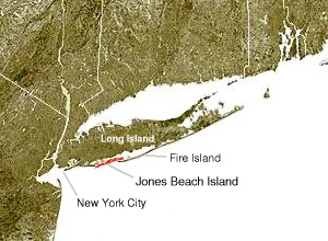
The southern side of the island is known for its beaches that face the open Atlantic Ocean. Jones Beach State Park, on the western tip of the island is a summer recreational destination for the New York City area.

Charter fishing boats at Captree State Park Captree state park NY docks.jpg
Charter fishing boats at Captree State Park

It is accessible from Long Island on its western end by the Meadowbrook Parkway to Merrick, New York, the Loop Parkway to Long Beach, New York and the Wantagh Parkway to Wantagh, New York. Its eastern end is linked to Babylon, New York as well as to Fire Island, New York by the Robert Moses Causeway via the Great South Bay Bridge and the State Boat Channel Bridge. The Ocean Parkway connects all three causeways and runs the length of the island, while The Fire Island Inlet Bridge continues on the Robert Moses Causeway finding its way to the New York's Fire Island on the Atlantic Ocean.

Fire Island

Fire Island is a barrier island, approximately 31 miles (50 km) long and varying between approximately 0.1 mile (160 m) to 0.25 mile (400 m) wide. Fire Island passes through southern Suffolk County, New York, and is southeast of Long Island separated from the main land by the Great South Bay in the U.S. state of New York, running approximately SW to NE. The land area is 8.687 sq. mi. (22.5 km2), and a permanent population of 491 people was reported as of the 2000 census. (There are hundreds of thousands of summertime residents, groupers and daytrippers.) The island is composed of three communities, as defined by the Census Bureau. The largest of these is Fire Island (CDP), which is unincorporated and stretches through the southern portion of the towns of Babylon, Islip, and Brookhaven.

FI Lighthouse pan.jpg
Distorted panoramic view of western Fire Island from the top of Fire Island Lighthouse

There are several ocean front communities such as, Davis Park and Watch Hill that are on the eastern side of the Great south bay. Fire Island has a variety of ocean front communities that can be reached by private boat, or seasonal ferry service from Long Island's mainland. Fire Island has a 2000 census population of 310 inhabitants. There are also two villages in the Islip section of the island, Saltaire (pop. 43) and Ocean Beach (pop. 138). In addition, a part of Fire Island CDP is not even on the island, but on a separate island adjacent to West Hampton Dunes.

Fire Island Inlet is an inlet on the south shore of Long Island, New York. It connects the Great South Bay with the Atlantic Ocean, passing between Robert Moses State Park (the western end of Fire Island) on the south and Oak Beach and Captree State Park (the eastern end of Jones Island) on the north. The stated land area and population figures result when this section is subtracted out. [2] The inlet is directly south of West Islip, the nearest town on the main part of Long Island.

The Lighthouse at the Fire Island National Seashore Robert Moses Lighthouse 1024.jpg
The Lighthouse at the Fire Island National Seashore

The inlet has evolved over the years due to natural processes, especially longshore drift. Jones Island and Fire Island at one time were connected. The Fire Island Light was at the mouth of the inlet when built in 1858, but is now six miles east of the inlet.

Westhampton Island

Westhampton Island [3] is the easternmost outer barrier island in the Town of Southampton. The barrier island was part of Fire Island until a nor'easter in 1931 created Moriches Inlet and made Fire Island a proper island. In 1938, Shinnecock Inlet created this fourth barrier island. Cupsogue Beach County Park is located on the western end of the island.

NASA satellite map of Moriches inlet Mastic-inlet-map.jpg
NASA satellite map of Moriches inlet

Moriches Inlet is an inlet connecting Moriches Bay and the Atlantic Ocean. The inlet created a geographic oddity whereby the Town of Brookhaven actually has jurisdiction on land immediately west of the village of West Hampton Dunes although Brookhaven land access to it involves a nearly 20 mile drive through Southampton.

Shinnecock Inlet is the easternmost of five major inlets [4] connecting bays to the Atlantic Ocean through the narrow 100-mile-long barrier islands that stretch from New York City to Southampton, New York on the south shore of Long Island.

The inlet was formed by the Great Hurricane of 1938 which killed several people when it permanently broke through the island in Hampton Bays, New York.

The inlet is almost directly lined up with the Shinnecock Canal between Shinnecock Bay and the Peconic Bay and saves miles for boaters going to the open Atlantic. Consequently, management has been geared to keep the inlet dredged and open. However, maintenance of the inlet has been controversial on grounds that it causes beach erosion on Fire Island.

Great South Bay at mid-2007 sunset FireIslandSummerDrawsToAClose.jpg
Great South Bay at mid-2007 sunset

See also

Map of Rockaway Inlet Jamaicabay-1.gif
Map of Rockaway Inlet

Related Research Articles

<span class="mw-page-title-main">Suffolk County, New York</span> County in New York, United States

Suffolk County is the easternmost county in the U.S. state of New York. It comprises the eastern two-thirds of Long Island, bordered to its west by Nassau County, to its east by Gardiners Bay and the Atlantic Ocean, to its north by Long Island Sound, and to its south by Great South Bay.

<span class="mw-page-title-main">Babylon, New York</span> Town in New York, United States

The Town of Babylon is one of ten towns in Suffolk County, New York, United States. Its population was 218,223 as of the 2020 census. Parts of Jones Beach Island, Captree Island and Fire Island are in the southernmost part of the town. It borders Nassau County to the west and the Atlantic Ocean to the south. At its westernmost point, it is about 20 miles (32 km) from New York City at the Queens border, and about 30 miles (48 km) from Manhattan. The village of Babylon is also within the town.

<span class="mw-page-title-main">Great South Bay</span>

The Great South Bay is a lagoon situated between Long Island and Fire Island, in the State of New York. It is about 45 miles (72 km) long and has an average depth of 4 feet 3 inches (1.3 m) and is 20 feet (6.1 m) at its deepest. It is protected from the Atlantic Ocean by Fire Island, a barrier island, as well as the eastern end of Jones Beach Island and Captree Island.

<span class="mw-page-title-main">Jones Beach Island</span>

Jones Beach Island is one of the outer barrier islands off the southern coast of Long Island in the U.S. state of New York.

<span class="mw-page-title-main">Fire Island</span> Island in New York

Fire Island is the large center island of the outer barrier islands parallel to the South Shore of Long Island, in the U.S. state of New York.

<span class="mw-page-title-main">Robert Moses Causeway</span>

The Robert Moses Causeway is an 8.10-mile-long (13.04 km) parkway in Suffolk County, New York on Long Island. It is named for the master builder and urban planner Robert Moses. The parkway, originally known as the Captree Causeway, connects West Islip on Long Island to the barrier beach islands, such as Captree Island, Jones Beach Island, and the western tip of Fire Island, to the south. It is designated New York State Route 908J (NY 908J), an unsigned reference route. Except south of NY 27A, the road, like most parkways in New York State, is limited to non-commercial traffic.

<span class="mw-page-title-main">Fire Island National Seashore</span> National park system unit in New York, United States

Fire Island National Seashore (FINS) is a United States National Seashore that protects a 26-mile (42 km) section of Fire Island, an approximately 30-mile (48 km) long and 0.5-mile (0.80 km) wide barrier island separated from Long Island by the Great South Bay. The island is part of New York State's Suffolk County and the Outer Barrier.

<span class="mw-page-title-main">Captree State Park</span> State park in New York, United States

Captree State Park is a 340-acre (1.4 km2) state park located in the towns of Babylon and Islip in Suffolk County, New York, United States. The park is located south of Captree Island on the easternmost end of Jones Beach Island, and overlooks the Fire Island Inlet and the westernmost section of Fire Island.

<span class="mw-page-title-main">Smith Point County Park</span>

Smith Point County Park is a beachfront park facing the Atlantic Ocean on the east end of Fire Island, along the central south shore of Long Island, near Shirley, New York, United States. It is the largest park owned by Suffolk County.

<span class="mw-page-title-main">Ocean Parkway (Long Island)</span>

The Ocean Parkway is a 15.59-mile (25.09 km) parkway that traverses Jones Beach Island between Jones Beach State Park and Captree State Park on Long Island, New York, in the United States. It begins at the southern terminus of the Meadowbrook State Parkway and heads east across Jones Beach Island, intersecting the south end of the Wantagh State Parkway before ending just past the southern terminus of the Robert Moses Causeway. The highway is designated New York State Route 909D (NY 909D), an unsigned reference route.

Shinnecock Inlet is the easternmost of five major inlets connecting bays to the Atlantic Ocean through the narrow 100-mile-long (160 km) Outer Barrier that stretches from New York City to Southampton, New York on the south shore of Long Island. It splits Westhampton Island from the peninsula extending from Southampton Village. The inlet was formed by the Great Hurricane of 1938, which killed several people when it permanently broke through the island in Hampton Bays, New York. The name comes from the Shinnecock Indian Nation.

<span class="mw-page-title-main">East Rockaway Inlet</span>

The East Rockaway Inlet is an arm of the Atlantic Ocean which separates the Rockaway Peninsula from the barrier island which includes the Nassau County, New York communities of Atlantic Beach, Long Beach and Lido Beach. The inlet is on the south shore of Long Island. It provides for a channel 12 feet deep and 250 feet wide. A 3,000 foot jetty on the western side of the channel was authorized but never constructed, and was eventually deauthorized by Congress in 1977.

<span class="mw-page-title-main">Moriches Inlet</span>

Moriches Inlet is an inlet connecting Moriches Bay and the Atlantic Ocean. The name Moriches comes from Meritces, a Native American who owned land on Moriches Neck.

<span class="mw-page-title-main">Fire Island Inlet</span>

Fire Island Inlet is an inlet on the south shore of Long Island, New York.

<span class="mw-page-title-main">Cupsogue Beach County Park</span>

Cupsogue Beach County Park is a 296-acre (1.20 km2) park at the eastern end of Fire Island and the western end of Westhampton Island, known locally as Dune Road, one of Long Island's easternmost barrier islands. The Atlantic Ocean, Moriches Inlet and Moriches Bay surround the park.

<span class="mw-page-title-main">Great South Bay Bridge</span> Bridge

The Great South Bay Bridge is a bridge on the southwest side of Suffolk County, New York, on Long Island. It connects the Robert Moses Causeway from Long Island's mainland over the Great South Bay, connecting to Captree and Jones Beach islands. It serves as access via the Robert Moses Causeway to both of the downstream crossings, the State Boat Channel Bridge and the Fire Island Inlet Bridge, also leading visitors and on-lookers to either the Fire Island Lighthouse or the Robert Moses State Park.

<span class="mw-page-title-main">State Boat Channel Bridge</span> Bridge

The State Boat Channel Bridge is a bascule bridge (drawbridge) in Suffolk County, New York, United States. It crosses over the Long Island New York State Boat Channel connecting Captree Island and Jones Beach Island on Robert Moses Causeway in the Oak Beach–Captree area within the town of Babylon.

<span class="mw-page-title-main">Ponquogue Parkway</span>

In 1938, after the destruction to Fire Island from the Long Island Express hurricane, Robert Moses and W. Earle Andrews, both part of the Long Island State Park Commission, proposed reconstruction of the island. This proposal included an extension of the Ocean Parkway out from its terminus at Captree State Park across Fire Island to Westhampton. This new parkway, which would boast 22 feet (6.7 m) wide roadways, would have connections back to the mainland at Smith Point County Park and Ponquogue with parkway spurs across Shinnecock Bay and the Great South Bay. The new spur at Ponquogue, deemed the Ponquogue Parkway, would have marked the eastern terminus of the new Ocean Parkway extension. The proposal lived until the cut-back to Smith Point County Park in 1962 for environmental issues with such a construction, ending any proposal for a parkway in the area of Hampton Bays.

Captree is a census-designated place (CDP) in the towns of Islip and Babylon in Suffolk County, New York, United States. It occupies Captree Island in Great South Bay, as well as the east end of Jones Beach Island to the south, comprising Captree State Park. It was first listed as a CDP prior to the 2020 census. Prior to that it was part of the Oak Beach–Captree CDP.

References

  1. Cody, Sarah K.; Auwaerter, John; Curry, George W. (2009). "Cultural Landscape Report for Floyd Bennett Field" (PDF). nps.gov . State University of New York, College of Environmental Science and Forestry: 16.
  2. "U.S. Census website" . Retrieved March 29, 2020.
  3. "GNIS Detail - Westhampton Island".
  4. "ADCIRC Example, Shinnecock Inlet". www.nd.edu. Archived from the original on January 3, 2005.

40°37′N73°16′W / 40.62°N 73.26°W / 40.62; -73.26