Bayville, New York | |
---|---|
Incorporated Village of Bayville | |
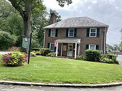
![]() Bayville Village Hall on August 29, 2021. | |
Nickname: Pine Island | |
![]() Location in Nassau County and the state of New York. | |
Coordinates: 40°54′26″N73°33′26″W / 40.90722°N 73.55722°W | |
Country | ![]() |
State | ![]() |
County | ![]() |
Town | Oyster Bay |
Incorporated | 1919 |
Government | |
• Type | Board of Trustees |
• Mayor | Steve Minicozzi (T) |
• Board of Trustees | Members' List |
Area | |
• Total | 1.55 sq mi (4.02 km2) |
• Land | 1.46 sq mi (3.77 km2) |
• Water | 0.10 sq mi (0.25 km2) |
Elevation | 39 ft (12 m) |
Population (2020) | |
• Total | 6,748 |
• Density | 4,637.80/sq mi (1,790.05/km2) |
Time zone | UTC-5 (Eastern (EST)) |
• Summer (DST) | UTC-4 (EDT) |
ZIP code | 11709 |
Area code | 516 |
FIPS code | 36-05034 |
GNIS feature ID | 0943216 |
Website | bayvilleny |
Bayville (sometimes also referred to as Pine Island) is a village located in the Town of Oyster Bay in Nassau County, on the North Shore of Long Island, in New York, United States. The population was 6,669 at the 2010 census. [2]
The Incorporated Village of Bayville is located on the Long Island Sound facing Greenwich, Connecticut.
Bayville incorporated as a village in 1919 during the incorporated village movement which allowed many larger estate owners on Long Island to establish political and security control over their domains. [3] [4]
Like many other Long Island communities, Bayville was first occupied by the Matinecock Indians and was known as Oak Neck and Pine Island. In 1658, Oyster Bay resident Daniel Whitehead purchased the land from the tribes. By 1745, the land was split among 23 men, who mainly grew asparagus. In 1859, Oak Neck was renamed Bayville and the first Methodist church was constructed west of what is now Merritt Lane. Multiple estates were built in the surrounding areas, and in 1898 a drawbridge was built, connecting Bayville and Mill Neck. [4] [5]
In 1909, the Bayville Casino opened for business, attracting beachgoers, and in 1919, Winslow S. Pierce, who owned the Dunstable Estate in town, was elected the first mayor of the Village of Bayville. The Dunstable Estate was sold to Harrison Williams and renamed "Oak Point". [6] When the Arlington Hotel, Bayville Casino, and Ritzmore Estate burned to the ground, it prompted the creation of the Bayville Fire Department. Bayville was put on the front page of many newspapers in 1927 when the rum rummer William T. Bell ran ashore at the Oak Point estate. Things were a little slow for a while, but after World War II, the community began to boom. A new church, post office, and school were built in the span of three years, and from 1950 to 1960, the population doubled.
The Bayville Bridge, one of two entrances into the village, opened in 1938 and is a major landmark and tourist attraction; it is the fourth bridge at that location. [7] [8] [9] [10]
The village celebrated its centennial in 2019. [11]
According to the United States Census Bureau, the village has a total area of 1.5 square miles (3.9 km2), of which 1.4 square miles (3.6 km2) is land and 0.1 square miles (0.26 km2), or 3.42%, is water. [12]
Census | Pop. | Note | %± |
---|---|---|---|
1930 | 1,042 | — | |
1940 | 1,516 | 45.5% | |
1950 | 1,981 | 30.7% | |
1960 | 3,962 | 100.0% | |
1970 | 6,147 | 55.1% | |
1980 | 7,034 | 14.4% | |
1990 | 7,193 | 2.3% | |
2000 | 7,135 | −0.8% | |
2010 | 6,669 | −6.5% | |
2020 | 6,748 | 1.2% | |
U.S. Decennial Census [13] |
As of the census [14] of 2000, there were 7,135 people, 2,566 households, and 1,906 families residing in the village. The population density was 5,065.7 inhabitants per square mile (1,955.9/km2). There were 2,683 housing units at an average density of 1,904.9 per square mile (735.5/km2). The racial makeup of the village was 96.01% White, 0.31% African American, 0.24% Native American, 1.64% Asian, 1.08% from other races, and 0.73% from two or more races. Hispanic or Latino of any race were 4.82% of the population.
There were 2,566 households, out of which 33.6% had children under the age of 18 living with them, 61.1% were married couples living together, 9.7% had a female householder with no husband present, and 25.7% were non-families. 20.6% of all households were made up of individuals, and 7.6% had someone living alone who was 65 years of age or older. The average household size was 2.74 and the average family size was 3.20.
In the village, the population was spread out, with 23.6% under the age of 18, 5.9% from 18 to 24, 29.6% from 25 to 44, 27.5% from 45 to 64, and 13.4% who were 65 years of age or older. The median age was 40 years. For every 100 females, there were 95.9 males. For every 100 females age 18 and over, there were 95.0 males.
The median income for a household in the village was $68,380, and the median income for a family was $77,838. Males had a median income of $50,969 versus $38,304 for females. The per capita income for the village was $33,665. About 2.7% of families and 4.7% of the population were below the poverty line, including 3.7% of those under age 18 and 8.3% of those age 65 or over.
As of October 2022, the Mayor of Bayville is longtime resident Steve Minicozzi and the Village Trustees are Valerie M. Belcher, Patricia Farnell, Robert M. Nigro, Elisa Santoro, and Peter B. Valsecchi. [15]
The school district is Locust Valley Central School District. [16]
Ives Estates is a census-designated place (CDP) in Miami-Dade County, Florida. It is part of the Miami metropolitan area of South Florida. The population was 25,005 at the 2020 census, up from 19,525 in 2010.
Litchfield is a town in Hillsborough County, New Hampshire, United States. The population was 8,478 at the 2020 census.
Brookville is a village located within the Town of Oyster Bay in Nassau County, on the North Shore of Long Island, in New York, United States. The population was 2,939 at the time of the 2020 census.
Centre Island is an upscale residential village located within the Town of Oyster Bay in Nassau County, on Long Island, in New York, United States. Centre Island is home to many high profile figures in politics, advertising, media, finance, and entertainment. Its population was 407 at the time of the 2020 census.
Locust Valley is a hamlet and census-designated place (CDP) located in the Town of Oyster Bay in Nassau County, on the North Shore of Long Island, in New York, United States. The population was 3,406 at the 2010 census.
Mill Neck is a village in the Town of Oyster Bay in Nassau County, on the North Shore of Long Island, in New York, United States. The population was 1,054 at the time of the 2020 census.
Muttontown is a village located within the Town of Oyster Bay in Nassau County, on Long Island, in New York, United States. The population was 3,497 at the 2010 census. it is part of the Greater Syosset area anchored by Syosset.
New Hyde Park is a village in the Towns of Hempstead and North Hempstead in Nassau County, on Long Island, in New York, United States. It is the anchor community of the Greater New Hyde Park area. The population was 10,257 at the time of the 2020 census.
Oyster Bay Cove is a village located within the Town of Oyster Bay in Nassau County, on the North Shore of Long island, in New York, United States. It is considered part of the Greater Oyster Bay area, which is anchored by Oyster Bay. The population was 2,265 at the time of the 2020 census.
Stewart Manor is a village in the Town of Hempstead in Nassau County, on Long Island, in New York, United States. The population was 1,992 at the time of the 2020 census.
Upper Brookville is a village located within the Town of Oyster Bay in Nassau County, on the North Shore of Long Island, in New York, United States. The population was 1,786 at the time of the 2020 census.
Belle Terre is a village in the Town of Brookhaven in Suffolk County, on the North Shore of Long Island, in New York, United States. The population was 792 at the 2010 census.
East Islip is a hamlet and CDP in the Town of Islip, Suffolk County, New York, United States. The population was 13,931 at the time of the 2020 census.
Fort Salonga is a hamlet and census-designated place (CDP) in the Towns of Huntington and Smithtown in Suffolk County, on the North Shore of Long Island, in New York, United States. The population was 10,008 at the 2010 census.
Holbrook is a hamlet and census-designated place (CDP) in Suffolk County, New York, United States. The population was 27,195 at the 2010 census. The community borders the eastern side of Long Island MacArthur Airport.
Islip Terrace is a hamlet and census-designated place (CDP) in the Town of Islip in Suffolk County, on the South Shore of Long Island, in New York, United States. The population was 5,323 at the time of the 2020 census.
Lloyd Harbor is a village in the Town of Huntington in Suffolk County, on the North Shore of Long Island, in New York, United States. As of the 2010 census, the village's population was 3,660.
Chester is a village in Orange County, New York, United States. The population was 3,993 at the 2020 census. It was named after the City of Chester in the Cheshire region of northwest England. Chester is part of the Poughkeepsie–Newburgh–Middletown, NY Metropolitan Statistical Area as well as the larger New York–Newark–Bridgeport, NY-NJ-CT-PA Combined Statistical Area.
Sandy Creek is a town in Oswego County, New York, United States. The population was 3,939 at the time of the 2010 census. The name is derived from a creek in the area.
Oyster Bay is a hamlet and census-designated place (CDP) within – and the Town Seat of – the Town of Oyster Bay, in Nassau County, on the North Shore of Long Island, in New York, United States. The population was 7,049 at the time of the 2020 census.