Salisbury, Nassau County, New York

Last updated

Salisbury, New York
South Westbury
Salisbury, Nassau County, Long Island, New York August 25, 2021 C.jpg
A street in Salisbury on August 25, 2021.
Nassau County New York incorporated and unincorporated areas Salisbury highlighted.svg
Location in Nassau County and the state of New York
USA New York location map.svg
Red pog.svg
Salisbury, New York
Location within the state of New York
Coordinates: 40°44′43″N73°33′34″W / 40.74528°N 73.55944°W / 40.74528; -73.55944
Country Flag of the United States.svg  United States
State Flag of New York.svg  New York
County Flag of Nassau County, New York.svg  Nassau County, New York
Town Hempstead
Named for Reminiscence to Salisbury Plain, England
Area
  Total1.7 sq mi (4 km2)
  Land1.7 sq mi (4 km2)
  Water0.0 sq mi (0.0 km2)
Elevation
108 ft (33 m)
Population
 (2010)
  Total12,093
  Density7,100/sq mi (2,700/km2)
Time zone UTC-5 (Eastern (EST))
  Summer (DST) UTC-4 (EDT)
Website eastmeadowchamber.com

Salisbury (formerly known as South Westbury) is a hamlet and census-designated place (CDP) in the Town of Hempstead in Nassau County, on Long Island, in New York, United States. The population was 12,093 at the 2010 census.

Contents

Many Levitt style homes lie adjacent to Eisenhower Park (formerly known as Salisbury Park).

It is served by the Westbury Railroad Station of the Long Island Railroad and shares fire districts with Westbury and East Meadow. [1]

History

Salisbury is so named because it sits on a broad, flat section of the larger Hempstead Plains that reminded late 19th Century Long Islanders of the Salisbury Plain in England, where Stonehenge is located. [2] This name was made the CDP's official name for the 1990 census, replacing the older name of South Westbury (which referenced its geographic location immediately south of Westbury). [3]

Geography

U.S. Census map of Salisbury. Salisbury-nassau-ny-map.gif
U.S. Census map of Salisbury.

According to the United States Census Bureau, the CDP has a total area of 1.7 square miles (4.5 km2), of which 1.7 square miles (4.5 km2) is land and 0.57% is water. [4]

According to the United States Geological Survey, Salisbury is located at an elevation of 108 feet (33 m). [5]

Demographics

At the 2000 census, [6] there were 12,341 people, 4,015 households and 3,340 families residing in the CDP. The population density was 7,164.1 inhabitants per square mile (2,766.1/km2). There were 4,052 housing units at an average density of 2,352.3 per square mile (908.2/km2). The racial makeup of the CDP was 89.94% White, 1.03% African American, 0.14% Native American, 5.97% Asian, 0.01% Pacific Islander, 1.60% from other races, and 1.31% from two or more races. Hispanic or Latino people of any race were 8.56% of the population.

There were 4,015 households, of which 37.2% had children under the age of 18 living with them, 69.9% were married couples living together, 10.4% had a female householder with no husband present, and 16.8% were non-families. 13.9% of all households were made up of individuals, and 8.3% had someone living alone who was 65 years of age or older. The average household size was 3.06 and the average family size was 3.35.

Age distribution was with 24.4% under the age of 18, 7.1% from 18 to 24, 28.2% from 25 to 44, 24.7% from 45 to 64, and 15.6% who were 65 years of age or older. The median age was 39 years. For every 100 females, there were 93.0 males. For every 100 females age 18 and over, there were 89.5 males.

The median household income was $73,641, and the median family income was $81,110. Males had a median income of $50,503 versus $37,002 for females. The per capita income for the CDP was $27,579. About 1.9% of families and 3.7% of the population were below the poverty line, including 3.5% of those under age 18 and 4.3% of those age 65 or over.

Education

Salisbury is located primarily located within the boundaries of (and is thus served by) the East Meadow Union Free School District, although a small portion zoned for commercial use is within the Uniondale Union Free School District. [1] As such, all children who reside within Salisbury and attend public schools go to East Meadow's schools. [1]

Related Research Articles

<span class="mw-page-title-main">Baldwin Harbor, New York</span> Hamlet and former census-designated place in New York, United States

Baldwin Harbor is a hamlet and former census-designated place (CDP) in the Town of Hempstead, in Nassau County, on Long Island, in New York, United States. It was created concomitant with the 1990 United States Census from the southernmost portions of the neighboring hamlet of Baldwin. As of the 2010 census, it had a population of 8,102.

<span class="mw-page-title-main">Bay Park, New York</span> Hamlet and census-designated place in New York, United States

Bay Park is a hamlet and census-designated place (CDP) in the Town of Hempstead in Nassau County, on the South Shore of Long Island, in New York, United States. The population was 2,212 at the 2010 census.

<span class="mw-page-title-main">Carle Place, New York</span> Hamlet and census-designated place in New York, United States

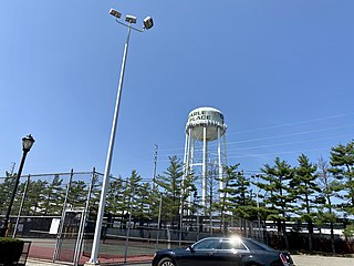
Carle Place is a hamlet and census-designated place (CDP) in the Town of North Hempstead in Nassau County, on Long Island, in New York, United States. The CDP's population was 4,981 at the 2010 census.

<span class="mw-page-title-main">East Atlantic Beach, New York</span> Hamlet and census-designated place in New York, United States

East Atlantic Beach is a hamlet and census-designated place (CDP) in Nassau County, New York, United States. The population was 2,049 at the 2010 census. The unincorporated hamlet is governed by the Town of Hempstead, one of three towns in Nassau County.

<span class="mw-page-title-main">East Meadow, New York</span> Hamlet and census-designated place in New York, United States

East Meadow is a hamlet and census-designated place (CDP) in the Town of Hempstead in Nassau County, on Long Island, in New York. The population was 38,132 at the 2010 census.

<span class="mw-page-title-main">Garden City Park, New York</span> Hamlet and census-designated place in New York, United States

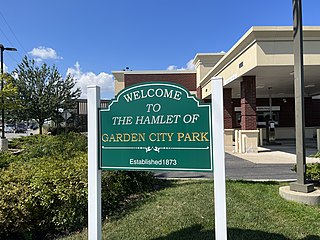
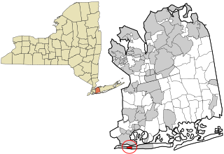
Garden City Park is a hamlet and census-designated place (CDP) located in the Town of North Hempstead in Nassau County, on Long Island, in New York, United States. The population was 7,806 at the 2010 census.

<span class="mw-page-title-main">Harbor Hills, New York</span> Hamlet and census-designated place in New York, United States

Harbor Hills is a hamlet and census-designated place (CDP) located on the Great Neck Peninsula within the Town of North Hempstead in Nassau County, on the North Shore of Long Island, in New York, United States. The population was 575 at the 2010 census.

<span class="mw-page-title-main">Herricks, New York</span> Hamlet and census-designated place in New York, United States

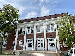
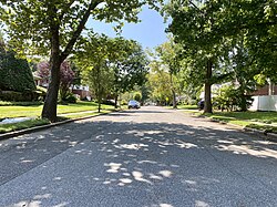
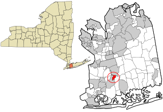
Herricks is a hamlet and census-designated place (CDP) in Nassau County, on Long Island, in New York, United States. The population was 4,398 at the 2020 census.

<span class="mw-page-title-main">Inwood, New York</span> Hamlet and census-designated place in New York, United States

Inwood is a hamlet and census-designated place (CDP) in Nassau County, on Long Island, in New York, United States. The population was 9,792 at the 2010 census. It is considered part of Long Island's Five Towns area and is located within the Town of Hempstead.

<span class="mw-page-title-main">Lakeview, New York</span> Hamlet and Census-designated place in New York, United States

Lakeview is a hamlet and census-designated place (CDP) in the Town of Hempstead in Nassau County, on Long Island, in New York, United States. The population was 6,077 at the 2020 census.

<span class="mw-page-title-main">Malverne Park Oaks, New York</span> Hamlet and Census-designated place in New York, United States

Malverne Park Oaks is a hamlet and census-designated place (CDP) in the Town of Hempstead in Nassau County, on Long Island, in New York, United States. The population was 538 at the 2020 census.

<span class="mw-page-title-main">New Cassel, New York</span> Hamlet and census-designated place in New York, United States

New Cassel is a hamlet and census-designated place (CDP) in the Town of North Hempstead in Nassau County, on Long Island, in New York, United States. The population was 14,059 at the 2010 census, representing a net gain of 761 over the 2000 census.

<span class="mw-page-title-main">North Lynbrook, New York</span> Hamlet and census-designated place in New York, United States

North Lynbrook is a hamlet and census-designated place (CDP) in the Town of Hempstead in Nassau County, on Long Island, in New York, United States. The population was 747 at the 2020 census.

<span class="mw-page-title-main">North Merrick, New York</span> Hamlet and Census-designated place in New York, United States

North Merrick is a hamlet and census-designated place in the Town of Hempstead, in Nassau County, near the South Shore of Long Island, in New York, United States. The population was 12,238 on the 2020 census.

<span class="mw-page-title-main">North New Hyde Park, New York</span> Hamlet and census-designated place in New York, United States

North New Hyde Park is a hamlet and census-designated place (CDP) in the Town of North Hempstead in Nassau County, on Long Island, in New York, United States. The population was 15,657 at the 2020 census.

<span class="mw-page-title-main">North Valley Stream, New York</span> Hamlet and Census-designated place in New York, United States

North Valley Stream is a hamlet and census-designated place (CDP) in the Town of Hempstead in Nassau County, on Long Island, in New York, United States. The population was 18,197 at the time of the 2020 census.

<span class="mw-page-title-main">South Hempstead, New York</span> Hamlet and census-designated place in New York, United States

South Hempstead is a hamlet and census-designated place (CDP) in the Town of Hempstead in Nassau County, on Long Island, in New York, United States. The population was 3,406 at the time of the 2020 census.

<span class="mw-page-title-main">South Valley Stream, New York</span> Hamlet and census-designated place in New York, United States

South Valley Stream is an unincorporated hamlet and census-designated place (CDP) in the Town of Hempstead in Nassau County, on Long Island, in New York, United States. The population was 6,386 as of the 2020 census.

<span class="mw-page-title-main">Uniondale, New York</span> Hamlet and census-designated place in New York, United States

Uniondale is a hamlet and census-designated place in Nassau County, New York, on Long Island, in the Town of Hempstead. The population was 32,473 at the 2020 United States Census. Uniondale is home to Hofstra University's north campus, as well as a portion of its southern campus.

<span class="mw-page-title-main">West Hempstead, New York</span> Hamlet and census-designated place in New York, United States

West Hempstead is a hamlet and census-designated place (CDP) in the Town of Hempstead in Nassau County, on Long Island, in New York, United States. The population was 19,835 at the time of the 2020 census. It is an unincorporated area in the Town of Hempstead and is represented by Councilman Edward Ambrosino.

References

  1. 1 2 3 "Long Island Index: Interactive Map". www.longislandindexmaps.org. Retrieved August 20, 2021.
  2. Winsche, Richard (October 1, 1999). The History of Nassau County Community Place-Names. Interlaken, New York: Empire State Books. ISBN   978-1557871541.
  3. "US Census Bureau Publications - Census of Population and Housing". www.census.gov. Retrieved October 4, 2021.
  4. "US Gazetteer files: 2010, 2000, and 1990". United States Census Bureau. February 12, 2011. Retrieved April 23, 2011.
  5. "GNIS Detail - Salisbury". geonames.usgs.gov. Retrieved August 26, 2021.
  6. "U.S. Census website". United States Census Bureau . Retrieved January 31, 2008.