Lido Beach, New York | |
---|---|
Coordinates: 40°35′17″N73°37′29″W / 40.58806°N 73.62472°W | |
Country | United States |
State | New York |
County | Nassau |
Town | Hempstead |
Area | |
• Total | 4.42 sq mi (11.45 km2) |
• Land | 1.69 sq mi (4.38 km2) |
• Water | 2.73 sq mi (7.07 km2) |
Elevation | 0 ft (0 m) |
Population (2020) | |
• Total | 2,719 |
• Density | 1,606.02/sq mi (620.25/km2) |
Time zone | UTC-5 (Eastern (EST)) |
• Summer (DST) | UTC-4 (EDT) |
ZIP code | 11561 |
Area codes | 516, 363 |
FIPS code | 36-42279 |
GNIS feature ID | 0955289 |
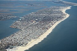
Lido Beach is a hamlet and census-designated place (CDP) in the Town of Hempstead in Nassau County, New York, United States. Located on the Long Beach Barrier Island, it is a suburb of the City of Long Beach, and is in the immediate metropolitan area. The population was 2,719 at the time of the 2020 census.
Lido Beach was developed by William H. Reynolds, in the early 1900s. [2] The 39-year-old former state senator and real estate developer had already developed four Brooklyn neighborhoods (Bedford-Stuyvesant, Borough Park, Bensonhurst, and South Brownsville), as well as Coney Island's Dreamland, the world's largest amusement park. Reynolds also owned a theater and produced plays. [2]
Beginning in 1906, he gathered investors and acquired the oceanfront from private owners and the rest of Long Beach island from the Town of Hempstead. [2] He planned to build a boardwalk, homes, and hotels, and dredged Reynolds Channel to create the Long Beach, New York resort area. [2] The dredging made the island more accessible to leisure boating.
The Lido Beach community was named after Venice Lido in Italy; "lido" means beach in Italian. [2] In 1929, after Reynolds was defeated for re-election as the Long Beach mayor, he turned his attention to the unincorporated area just east of the city and constructed the Moorish-style Lido Beach Hotel. [2]
Lido Beach is located between Long Beach and Point Lookout. [3]
According to the United States Census Bureau, the CDP has a total area of 4.3 square miles (11 km2), of which 1.7 square miles (4.4 km2) is land and 2.5 square miles (6.5 km2), or 59.62%, is water.
Census | Pop. | Note | %± |
---|---|---|---|
2020 | 2,719 | — | |
U.S. Decennial Census [4] |
As of the census [5] of 2020, there were 2,719 people, 1,182 households, and 813 families residing in the CDP. The population density was 1,666.0 inhabitants per square mile (643.2/km2). (As of 2020,) There were 1,302 housing units at an average density of 806.8 per square mile (311.5/km2). The racial makeup of the CDP was 96.11% White, 0.57% African American, 1.59% Asian, 0.78% from other races, and 0.96% from two or more races. Hispanic or Latino of any race were 2.87% of the population.
There were 1,802 households, out of which 27.5% had children under the age of 18 living with them, 63.4% were married couples living together, 5.6% had a female householder with no husband present, and 29.2% were non-families. 24.6% of all households were made up of individuals, and 13.1% had someone living alone who was 65 years of age or older. The average household size was 2.44 and the average family size was 2.93.
In the CDP, the population was spread out, with 21.8% under the age of 18, 4.3% from 18 to 24, 21.0% from 25 to 44, 31.6% from 45 to 64, and 27.6% who were 65 years of age or older. The median age was 53.1 years. For every 100 females, there were 97.1 males. For every 100 females age 18 and over, there were 90.2 males.
The median income for a household in the CDP was $172,857, and the median income for a family was $107,365. Males had a median income of $77,193 versus $68,542 for females. The per capita income for the CDP was $47,604. About 1.8% of families and 11.5% of the population were below the poverty line, including 3.1% of those under age 18 and 8.4% of those age 65 or over.
Activities and attractions at Lido Beach include:
Children's activities amenities, and attractions include:
(Alphabetized by surname)
Westbrook is a town in Middlesex County, Connecticut, United States. The town is part of the Lower Connecticut River Valley Planning Region. The population was 6,769 at the 2020 census. The town center is classified by the U.S. Census Bureau as a census-designated place (CDP).
Manasota Key is a census-designated place (CDP) consisting mainly of the community of Englewood Beach in Charlotte County, Florida, United States. The population of the CDP was 1,326 at the 2020 census, up from 1,229 at the 2010 census. It is part of the Punta Gorda, Florida Metropolitan Statistical Area, included in the North Port-Bradenton, Florida Combined Statistical Area.
South Sarasota is a census-designated place (CDP) in Sarasota County, Florida, United States. The population was 5,133 at the 2020 census, up from 4,950 at the 2010 census. It is part of the North Port–Bradenton–Sarasota, Florida Metropolitan Statistical Area.
Hawaiian Beaches is a census-designated place (CDP) in Hawaiʻi County, Hawaiʻi, United States located in the District of Puna. The population was 4,280 at the 2010 census, up from 3,709 at the 2000 census.
Pūpūkea is a community and census-designated place (CDP) in the Koʻolauloa District on the island of Oʻahu, City & County of Honolulu, Hawaii, United States. In Hawaiian, pūpūkea means "white shell". As of the 2020 census, the CDP had a population of 5,130. The Koʻolauloa District ends at Waimea Bay, with the Waialua District extending south and westward.
Poʻipū is a census-designated place (CDP) in Kauaʻi County on the southern side of the island of Kauaʻi in the U.S. state of Hawaiʻi. The population was 1,299 at the 2020 census. The town features a group of high-end hotels, resorts and two main shopping centers.
Kaanapali is a planned resort community in Maui County, Hawaii, United States, on the island of Maui located in the Old Hawaii ahupuaa of Hanakaʻōʻō, as in the same name of the southern end of Kaanapali Beach's Hanakaʻōʻō Canoe Beach. The population was 1,161 at the 2020 census. For statistical purposes, the United States Census Bureau has defined Kaanapali as a census-designated place (CDP).
East Atlantic Beach is a hamlet and census-designated place (CDP) in Nassau County, New York, United States. The population was 2,049 at the 2010 census. The unincorporated hamlet is governed by the Town of Hempstead, one of three towns in Nassau County.
Point Lookout is a hamlet and census-designated place (CDP) located in the town of Hempstead in Nassau County, New York, United States. The population was 1,527 at the time of the 2020 census. The town is mostly made up of residential homes, with several small businesses on Lido Boulevard. The town is surrounded on three sides by water. Today, Point Lookout has become a popular location for summer residences. Among its inhabitants, it is commonly referred to as "PLO".
Aquebogue is a census-designated place (CDP) roughly corresponding to the hamlet by the same name in the Town of Riverhead in Suffolk County, on Long Island, in New York, United States. The CDP's population was 2,438 at the 2010 census.
East Moriches is a hamlet and census-designated place in the Town of Brookhaven, Suffolk County, New York, United States. The population was 5,249 at the 2010 census.
Fort Salonga is a hamlet and census-designated place (CDP) in the Towns of Huntington and Smithtown in Suffolk County, on the North Shore of Long Island, in New York, United States. The population was 10,008 at the 2010 census.
Gilgo-Oak Beach-Captree, frequently just called Oak Beach, was a census-designated place (CDP) in Suffolk County, New York within the Town of Babylon. The population was 333 at the 2000 census.
Kings Park is a hamlet and census-designated place (CDP) in the Town of Smithtown, in Suffolk County, on Long Island, in New York, United States. The population was 17,282 as of the 2010 census.
Mastic Beach is a hamlet and census-designated place, and former village in the southeastern part of the Town of Brookhaven in Suffolk County, on Long Island, in New York, United States. The population was 14,849 at the 2010 census, when it was an unincorporated census-designated place for the first time.
Sound Beach, established in 1929, is a hamlet and census-designated place (CDP) in the north part of the Town of Brookhaven in Suffolk County, New York, United States. The population of the CDP was 7,612 at the 2010 census.
Springs is a census-designated place (CDP) roughly corresponding to the hamlet by the same name in the Town of East Hampton in Suffolk County, New York, United States, on the South Fork of Long Island. As of the 2010 United States Census, the CDP population was 6,592.
Shelter Island is a hamlet and census-designated place (CDP) within the Town of Shelter Island in Suffolk County, New York, United States. The population was 1,602 at the time of the 2020 census.
Water Mill is a hamlet and a census-designated place (CDP) within the Town of Southampton on Long Island in Suffolk County, New York, United States. The population of the CDP was 1,559 at the 2010 census. Its ZIP Code is 11976.
Gilgo is a hamlet and census-designated place (CDP) in the Town of Babylon in Suffolk County, New York, United States. The population was 185 at the time of the 2020 census.