East Meadow, New York

Last updated

East Meadow, New York
Nassau University Medical Center NW 2018.jpg
Nassau University Medical Center, one of the most prominent landmarks in East Meadow.
Nassau County New York incorporated and unincorporated areas East Meadow highlighted.svg
Location in Nassau County and the state of New York
Location map Long Island.png
Red pog.svg
East Meadow, New York
Location on Long Island
USA New York location map.svg
Red pog.svg
East Meadow, New York
Location within the state of New York
Coordinates: 40°42′49″N73°33′21″W / 40.71361°N 73.55583°W / 40.71361; -73.55583
Country Flag of the United States.svg  United States
State Flag of New York.svg  New York
County Nassau
Town Hempstead
Area
[1]
  Total6.33 sq mi (16.39 km2)
  Land6.30 sq mi (16.32 km2)
  Water0.02 sq mi (0.06 km2)
Elevation
72 ft (22 m)
Population
 (2020)
  Total37,796
  Density5,996.51/sq mi (2,315.31/km2)
Time zone UTC-5 (Eastern (EST))
  Summer (DST) UTC-4 (EDT)
ZIP Code
11554
Area code(s) 516, 363
FIPS code 36-22502
GNIS feature ID0973378
Website eastmeadowchamber.com

East Meadow is a hamlet and census-designated place (CDP) in the Town of Hempstead in Nassau County, on Long Island, in New York, United States. The population was 36,856 at the time of the 2024 census.

Contents

Many residents commute to Manhattan, which is 30 miles (48 km) away.

History

In 1655, two surveyors for Hempstead reported that the "east meadow" would be suitable for grazing. [2] The area quickly became a grazing area for cattle and later, in the 18th century, for sheep. The sheep of the East Meadow area provided the country with more than 50% of the United States' wool needs during that time. [2]

During the American Revolutionary War, East Meadow was occupied by British forces when they discovered the vast amounts of livestock herded there, and remained under their control until the end of the war. [2] Two large farms existed in what is now East Meadow: the Barnum farm (Barnum Woods), and the Carman farm. It is rumored that President George Washington spent a night on the Barnum estate during a trip across Long Island in 1790. [2] A toll booth was operated near the Carman homestead on the Hempstead Turnpike.

Another early settlement was located near what is now the intersection of East Meadow Avenue (formerly called Newbridge Avenue; not to be confused with nearby Newbridge Road) and Prospect Avenue. [2] [3] [4]

The community was home to many Gilded Era estates. The old Hoeffner homestead is now the site of Veterans Memorial park, and East Meadow's Post Office. The Barnum estate was rented by the Hoeffner family in 1914. Part of the old Barnum farm is now the site of Barnum Woods Elementary School, and the main road that passes by the school, Merrick Avenue, was originally called Barnum Avenue. The Oliver and Alva Belmont (formerly Alva Vanderbilt) estate of Brookholt once stretched across several hundred acres on both sides of Front Street to the west of Merrick Avenue, [5] and for a short while, included the Brookholt School of Agriculture for Women.

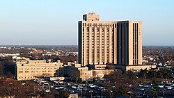
Carman Avenue is home to East Meadow High School, the Nassau County Correctional Facility, and the Nassau University Medical Center – the tallest inhabitable building in Nassau County.

On March 11, 2004, President George W. Bush made a visit to East Meadow for the groundbreaking of a new memorial for the victims of the September 11, 2001 attacks.[ citation needed ]

East Meadow's name is derived from being the meadow of Hempstead Plains east of the Meadow Brook (originally a brook, now replaced by a parkway of the same name). [6]

East Meadow has been chosen to host eight cricket matches of the ICC Men's T20 World Cup in June 2024.

Geography

U.S. Census Map East-meadow-ny-map.png
U.S. Census Map

According to the United States Census Bureau, the CDP has a total area of 6.3 square miles (16 km2), of which 6.3 square miles (16 km2) is land and 6.3% is water. [7]

East Meadow is generally flat, and according to the United States Geological Survey and the United States Environmental Protection Agency, the elevation ranges from 32 feet (9.8 m) near its southwestern edge, to 82 feet (25 m) along Hempstead Turnpike to the north. [8] [9]

Almost no actual meadow remains in East Meadow or the Hempstead Plains, due to the post-WWII development boom and later, unchecked suburban sprawl.

Demographics

Historical population
CensusPop.Note
2000 37,461
2010 38,1321.8%
2020 37,796−0.9%
U.S. Decennial Census [10]

As of the census of 2010, there were 38,132 people and 12,062 households residing in the CDP. (759.6/km2). [11]

As of the census of 2010, there were 38,132 people and 12,062 households residing in the CDP. (759.6/km2). [12]

The racial makeup of the CDP was according to the 2010 census, 77.3% White, 5.2% African American, 0.1% Native American, 11.6% Asian, 0.04% Pacific Islander, 1.0% from other races, 1.9% from two or more races, 12.2% Hispanic or Latino. Non Hispanic whites were 69.8% of the population. [12] The ancestries of residents of East Meadow are Italian (28.5%), Irish (17.5%), German (11.8%), Polish (8.8%), Russian (5.8%), United States (5.0%).

Of the 12,186 households, 35.8% had children under the age of 18 living with them, 67.2% were married couples living together, 9.0% had a female householder with no spouse present, and 20.8% were non-families. 17.9% of all households were made up of individuals, and 11.6% had someone living alone who was 65 years of age or older. The average household size was 2.94, and the average family size was 3.34.

In the CDP, the population was spread out, with 23.4% under the age of 18, 7.7% from 18 to 24, 30.1% from 25 to 44, 22.6% from 45 to 64, and 16.3% who were 65 years of age or older. The median age was 39 years. For every 100 females, there were 98.6 males. For every 100 females age 18 and over, there were 96.5 males.

The median income for a household in the CDP was $67,185, and the median income for a family was $74,691 (these figures had risen to $86,582 and $97,057 respectively as of a 2007 estimate [13] ). Males had a median income of $50,325, versus $35,422 for females. The per capita income for the CDP was $27,076. About 2.3% of families and 1.8% of the population were below the poverty line, including 4.1% of those under age 18 and 4.2% of those age 65 or over.

Economy

Getty Oil is based in East Meadow.

Snapple was previously headquartered in East Meadow, [14] prior to moving their corporate office. The office space is now currently occupied by the Epilepsy Foundation of Long Island. [15]

Lufthansa United States had its headquarters in East Meadow beginning in the 1970s, after it moved from Park Avenue in Manhattan, in order to save money. In 2019, the office had 206 employees; that year the headquarters moved to Uniondale. [16]

Education

East Meadow High School East Meadow High School New York.jpg
East Meadow High School

East Meadow's nine public schools are operated by the East Meadow Union Free School District, [17] Town of Hempstead School District #3. The district was originally organized in 1812 and then formally organized as Town of Hempstead Common School District #3 in 1814 under the name "Brushy Plains", and at one time was the third largest school district in New York State. The first school building was on Front Street (where the East Meadow Public Library [18] building stands today). Four successive schoolhouses stood at the corner of Newbridge Avenue (now East Meadow Avenue) and Front Street between 1814 and 1950.

Elementary schools

  • Barnum Woods [19]
  • Bowling Green [20]
  • George H. McVey (previously Meadowlawn) [21]
  • Meadowbrook [22]
  • Parkway [23]

Middle schools

High schools

Closed schools

Houses of worship

Landmarks

Nassau County's Eisenhower Park (formerly Salisbury Park), seen here in 2007, is located within East Meadow. Eisenhower Park Main Entrance.jpg
Nassau County's Eisenhower Park (formerly Salisbury Park), seen here in 2007, is located within East Meadow.

Movies filmed in East Meadow

Notable people

Related Research Articles

<span class="mw-page-title-main">Nassau County, New York</span> County in New York, United States

Nassau County is a suburban county located on Long Island, immediately to the east of New York City. As of the 2020 United States census, Nassau County's population was 1,395,774, making it the sixth-most populous county in the State of New York, and reflecting an increase of 56,242 (+4.2%) from the 1,339,532 residents enumerated at the 2010 census. Its county seat is Mineola, while the county's largest town is Hempstead. Along with the remainder of Long Island, Nassau County lies in the southeastern portion of New York State.

<span class="mw-page-title-main">Albertson, New York</span> Hamlet and census-designated place in New York, United States

Albertson is a hamlet and census-designated place (CDP) in the Town of North Hempstead in Nassau County, on Long Island, in New York, United States. The population was 5,220 at the time of the 2020 census.

<span class="mw-page-title-main">Barnum Island, New York</span> Hamlet and census-designated place in New York, United States

Barnum Island is a hamlet and census-designated place (CDP) in Nassau County, New York, United States. The population was 2,590 at the 2020 census. It occupies the eastern portion of an island situated between Long Island and Long Beach. That island, previously known in its entirety as Hog Island, consists entirely of the communities of Barnum Island and Island Park.

<span class="mw-page-title-main">Carle Place, New York</span> Hamlet and census-designated place in New York, United States

Carle Place is a hamlet and census-designated place (CDP) in the Town of North Hempstead in Nassau County, on Long Island, in New York, United States. The CDP's population was 5,005 at the time of the 2020 census.

<span class="mw-page-title-main">East Garden City, New York</span> Hamlet and former census-designated place in New York, United States

East Garden City is a hamlet and former census-designated place (CDP) in the northeast part of the Town of Hempstead, in the central part of Nassau County, on Long Island, in New York, United States, along the Hempstead/North Hempstead town line. The population was 6,208 at the 2010 census, when it was still listed as a CDP. Since then, it is now included in the Uniondale CDP.

<span class="mw-page-title-main">Elmont, New York</span> Hamlet and census-designated place in New York, United States

Elmont is an unincorporated hamlet and census-designated place (CDP) located in northwestern Hempstead in Nassau County, New York, United States, along its border with the borough of Queens in New York City. The population was 35,265 as of the 2020 census.

<span class="mw-page-title-main">Franklin Square, New York</span> Hamlet and census-designated place in New York, United States

Franklin Square is a hamlet and census-designated place (CDP) in the Town of Hempstead in Nassau County, on Long Island, New York, United States. The population was 30,903 at the time of the 2020 census.

<span class="mw-page-title-main">Glenwood Landing, New York</span> Hamlet and census-designated place in New York, United States

Glenwood Landing is a hamlet and census-designated place (CDP) in Nassau County, New York. The population was 3,948 at the time of the 2020 census.

<span class="mw-page-title-main">Greenvale, New York</span> Hamlet and census-designated place in New York, United States

Greenvale is a hamlet and census-designated place (CDP) in the towns of North Hempstead and Oyster Bay in Nassau County, on the North Shore of Long Island, in New York, United States. It is considered part of the Greater Roslyn area, which is anchored by the Incorporated Village of Roslyn. The population was 1,069 at the time of the 2020 census.

<span class="mw-page-title-main">Herricks, New York</span> Hamlet and census-designated place in New York, United States

Herricks is a hamlet and census-designated place (CDP) in Nassau County, on Long Island, in New York, United States. The population was 4,398 at the 2020 census.

<span class="mw-page-title-main">Manhasset Hills, New York</span> Hamlet and census-designated place in New York, United States

Manhasset Hills is a hamlet and census-designated place (CDP) in the Town of North Hempstead in Nassau County, on Long Island, in New York, United States. The population was 3,592 at the 2010 census. Neighboring communities include Herricks, North Hills, North New Hyde Park, and Lake Success.

<span class="mw-page-title-main">Port Washington, New York</span> Hamlet and CDP in Nassau County, New York

Port Washington is a hamlet and census-designated place (CDP) on the Cow Neck Peninsula in the Town of North Hempstead, in Nassau County, on the North Shore of Long Island, in New York. The hamlet is the anchor community of the Greater Port Washington area. The population was 16,753 at the 2020 census.

<span class="mw-page-title-main">Roslyn Heights, New York</span> Hamlet and census-designated place in New York, United States

Roslyn Heights is a hamlet and census-designated place (CDP) in the Town of North Hempstead in Nassau County, on the North Shore of Long Island, in New York, United States. It is considered part of the Greater Roslyn area, which is anchored by the Incorporated Village of Roslyn. The population was 6,747 at the time of the 2020 census.

<span class="mw-page-title-main">Saddle Rock Estates, New York</span> Hamlet and census-designated place in New York, United States

Saddle Rock Estates is a hamlet and census-designated place (CDP) located on the Great Neck Peninsula within the Town of North Hempstead in Nassau County, on the North Shore of Long Island, in New York, United States. The population was 466 at the 2010 census.

<span class="mw-page-title-main">Salisbury, Nassau County, New York</span> Hamlet and census-designated place in New York, United States

Salisbury is a hamlet and census-designated place (CDP) in the Town of Hempstead in Nassau County, on Long Island, in New York, United States. The population was 12,093 at the 2010 census.

<span class="mw-page-title-main">Searingtown, New York</span> Hamlet and census-designated place in New York, United States

Searingtown is a hamlet and census-designated place (CDP) in the Town of North Hempstead in Nassau County, on Long Island, in New York, United States. It is considered part of the Greater Roslyn area, which is anchored by the Village of Roslyn. The population was 4,915 at the 2010 census.

<span class="mw-page-title-main">University Gardens, New York</span> Hamlet and census-designated place in New York, United States

University Gardens is a hamlet and a census-designated place (CDP) in Nassau County, on the North Shore of Long Island, in New York, United States. It is located within the Town of North Hempstead and is part of the Greater Great Neck area. The population was 4,358 at the time of the 2020 census.

<span class="mw-page-title-main">Hempstead, New York</span> Town in New York, United States

The Town of Hempstead is the largest of the three towns in Nassau County on Long Island, in New York, United States. The town's combined population was 793,409 at the 2020 census, which is the majority of Nassau County's population and makes it, by far, the largest population of any town in the United States.

<span class="mw-page-title-main">New York State Route 106</span> State highway in Nassau County, New York, US

New York State Route 106 (NY 106) is a 13.28-mile (21.37 km) state highway located in Nassau County, New York, in the United States. It begins in the town of Hempstead at an intersection with NY 105 in North Bellmore and heads to the north, crossing the hamlets of East Meadow and Levittown before entering the town of Oyster Bay. In Hicksville, NY 106 becomes concurrent with NY 107, an overlap colloquially known as the "One oh Six–One oh Seven". The concurrency ends immediately after an interchange with Jericho Turnpike in the hamlet of Jericho. After breaking away from NY 107, NY 106 heads north across the villages of Brookville and Muttontown and the hamlet of East Norwich to the hamlet of Oyster Bay, where the route ends one block south of Oyster Bay Harbor.

<span class="mw-page-title-main">New York State Route 102</span> State highway in Nassau County, New York, US

New York State Route 102 (NY 102) is an east–west state highway in Nassau County, New York, in the United States. It is little more than an alternate route of NY 24 through the town of Hempstead. NY 102 leaves NY 24 in West Hempstead and follows Front Street through the village of Hempstead and Uniondale before rejoining NY 24 in East Meadow. The portion of NY 102 west of William Street is maintained by Nassau County and is unsigned while the remainder of the highway is maintained by the New York State Department of Transportation and signed. NY 102 goes under the Meadowbrook State Parkway, but has no connecting ramps to or from the parkway. It does, however have a right-of-way for a formerly proposed eastbound lane.

References

  1. "ArcGIS REST Services Directory". United States Census Bureau. Retrieved September 20, 2022.
  2. 1 2 3 4 5 Strong, Otto (April 22, 1990). "His Trips Down Memory Lane: Steve Buczak chronicles East Meadow's history". Newsday . pp. 1, 5 via ProQuest.
  3. "Street Gets a New Name". Newsday . March 24, 1982. p. 29 via ProQuest.
  4. Young, Gwen (February 3, 1982). "Street's Identity Crisis Bothers Merchants". Newsday . p. 23 via ProQuest.
  5. MacKay, Robert B.; Anthony K. Baker; Carol A. Traynor (1997). Long Island Country Houses and Their Architects, 1860–1940. New York: Society for the Preservation of Long Island Antiquities in association with W.W. Norton & Co. pp. 226–227, 359, 485. ISBN   978-0-393-03856-9.
  6. Winsche, Richard (October 1, 1999). The History of Nassau County Community Place-Names. Interlaken, New York: Empire State Books. ISBN   978-1557871541.
  7. "US Gazetteer files: 2010, 2000, and 1990". United States Census Bureau. February 12, 2011. Retrieved April 23, 2011.
  8. "EPA – Waters GeoViewer". United States Environmental Protection Agency . Archived from the original on April 1, 2019. Retrieved July 28, 2021.
  9. "The National Map - Advanced Viewer". United States Geological Survey . Archived from the original on February 2, 2021. Retrieved July 30, 2021.
  10. "Census of Population and Housing". Census.gov. Retrieved June 4, 2016.
  11. n/a, U.S Census Bureau (May 18, 2012). "East Meadow CDP, New York". Archived from the original on May 18, 2012. Retrieved May 20, 2023.
  12. 1 2 "East Meadow CDP QuickFacts from the US Census Bureau". census.gov. Archived from the original on May 20, 2013. Retrieved May 21, 2013.
  13. "East Meadow CDP, New York – Fact Sheet – American FactFinder". Factfinder.census.gov. Archived from the original on March 28, 2009. Retrieved July 29, 2010.
  14. Contract Design. Gralla Publications. 1996. p. 50. Retrieved January 20, 2024.
  15. "Epilepsy Foundation to revamp former Snapple HQ". Long Island Business News . Retrieved on September 24, 2012.
  16. Madore, James T. (March 5, 2019). "Lufthansa moves Americas headquarters, seeks tax breaks". Newsday . Retrieved May 17, 2020.
  17. "East Meadow School District". www.EastMeadow.k12.ny.us. Retrieved January 22, 2018.
  18. 1 2 System, Nassau Library. "East Meadow Public Library -". www.NassauLibrary.org. Retrieved January 22, 2018.
  19. "Index". www.eastmeadow.k12.ny.us. Archived from the original on January 23, 2018. Retrieved January 22, 2018.
  20. "Main Page". www.eastmeadow.k12.ny.us. Archived from the original on July 5, 2017. Retrieved January 22, 2018.
  21. "East Meadow School District". www.eastmeadow.k12.ny.us. Archived from the original on February 16, 2006. Retrieved January 22, 2018.
  22. "Home — Meadowbrook Elementary School — East Meadow School District". www.eastmeadow.k12.ny.us. Archived from the original on January 22, 2018. Retrieved January 22, 2018.
  23. "East Meadow School District". www.eastmeadow.k12.ny.us. Archived from the original on February 16, 2006. Retrieved January 22, 2018.
  24. "Woodland Middle School". www.eastmeadow.k12.ny.us. Archived from the original on January 23, 2018. Retrieved January 22, 2018.
  25. "East Meadow School District". www.eastmeadow.k12.ny.us. Archived from the original on February 12, 2006. Retrieved January 22, 2018.
  26. "Christ Alive Church, East Meadow, NY". www.christalivechurchny.org. 2011. Archived from the original on August 13, 2015. Retrieved December 10, 2015.
  27. Rosen, Oded (September 17, 2008). The Encyclopedia of Jewish ... Mosadot Publications. ISBN   9780913185001 . Retrieved July 29, 2010.
  28. "East Meadow Jewish Center – Conservative Synagogue, East Meadow, NY 11554". Eastmeadowjc.org. December 31, 2006. Retrieved August 21, 2010.
  29. Rosenberg, Joe. "East Meadow United Methodist Church". Google Maps. Retrieved July 29, 2010.
  30. "Holy Trinity Orthodox Church, East Meadow, NY". Holytrinityeastmeadow.org. November 19, 2008. Retrieved August 21, 2010.
  31. "LIMS :: Long Island Muslim Society". Limsinfo.org. Retrieved August 21, 2010.
  32. "St. Raphael Parish Home Page". www.StRaphaelParish.org. Retrieved January 22, 2018.
  33. "Wednesday's Lot List: Filming Locations in NYC, L.A., Chicago & more including 'Cheaters' & 'Something Borrowed'". On Location Vacations. June 2, 2010. Archived from the original on June 6, 2010. Retrieved February 8, 2012.
  34. "I Am Here - short - Movies Filmed on Long Island". www.moviesfilmedonlongisland.com.
  35. "Siegmund Spiegel Obituary (1919 - 2016) - Aventura, FL - Newsday". Legacy.com. Retrieved March 16, 2024.

Sources

Commons-logo.svg Media related to East Meadow, New York at Wikimedia Commons