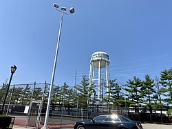
Carle Place Frog Hollow; Mineola Park | |
---|---|
Coordinates: 40°45′09″N073°36′37″W / 40.75250°N 73.61028°W [1] | |
Country | United States |
State | New York |
County | Nassau |
Town | North Hempstead |
Named for | Silas Carle |
Area | |
• Total | 0.96 sq mi (2.48 km2) |
• Land | 0.96 sq mi (2.48 km2) |
• Water | 0.00 sq mi (0.00 km2) |
Elevation | 108 ft (33 m) |
Population (2020) | |
• Total | 5,005 |
• Density | 5,224.43/sq mi (2,016.53/km2) |
Time zone | UTC-5 (Eastern (EST)) |
• Summer (DST) | UTC-4 (EDT) |
ZIP code [3] | 11514 |
Area codes | 516, 363 |
FIPS code [4] [5] | 36-12419 |
GNIS feature ID [5] | 945835 |
Website | wcpchamber |
Carle Place (also known historically as Frog Hollow and Mineola Park) is a hamlet and census-designated place (CDP) in the Town of North Hempstead in Nassau County, on Long Island, in New York, United States. The CDP's population was 5,005 at the time of the 2020 census. [6]
In 1946, developer William J. Levitt bought 19 acres of land near the Carle Place train station for an experiment. [7] His crews brought pre-cut lumber to the site and rapidly assembled 600 low-cost houses, offering affordable suburban living with an easy commute into offices in New York City. Within five years, returning veterans and their families swelled the population by 500 percent. It transformed Carle Place, and served as the prototype for Levittown, the larger development which Levitt began the following year only a few miles away. [8]
The hamlet is named for Silas Carle, or (more specifically) the Carle House – a 32-room house built by Carle in Westbury in the 1800s. It was commonly known as the "Carle Place", and the surrounding area later took the name. [7]
The area was also known as Mineola Park between circa 1895 and 1915, after an unsuccessful real estate development of the same name within the hamlet. [7] The name was reverted to Carle Place in 1915, and there was only one further attempt to change it, which took place in 1951 after Levitt & Sons purchased and developed much of the area consisting of the unsuccessful development. [7] The proposal failed, as the majority of residents preferred keeping the name, and no attempts to change it have taken place since. [7]
Another historic name for the area is Frog Hollow, which is still used colloquially and is the source of the Carle Place Union Free School District's mascot. [9] [10]
According to the United States Census Bureau, the CDP has a total area of 0.935 square miles (2.42 km2), all land. [1] [4]
The villages bordering Carle Place are Mineola, Garden City, and Westbury. [11] Carle Place also borders the part of Uniondale formerly known as East Garden City, an unincorporated area of the Town of Hempstead. [11]
Carle Place's southern border runs along Old Country Road, while its eastern border runs along Carle Road. [11]
The southern border also makes up part of the border between North Hempstead and Hempstead. [11]
Most of the western border runs along the path of the former Long Island Motor Parkway.
Carle Place is considered a bedroom community of the City of New York. [11] As such, many residents commute to/from New York for work. [12] The hamlet also consists of areas of varying sizes zoned for commercial, retail, and industrial uses. [11]
Additionally, Carle Place was formerly home to the headquarters of 1-800 Flowers. [13]
Census | Pop. | Note | %± |
---|---|---|---|
2000 | 5,247 | — | |
2010 | 4,981 | −5.1% | |
2020 | 5,005 | 0.5% | |
U.S. Decennial Census [14] |
As of the 2010 census [15] The make up of the population was 77.9% Non-Hispanic white, 2.1% Black or African American, 7.9% Asian, 3.8% from other races, and 1.9% from two or more races. Hispanic or Latino of any race were 11.1% of the population.
As of the 2000 census, [16] there were 5,247 people, 1,900 households, and 1,371 families residing in the CDP. The population density was 2,155.2/km2 (5,572.9/mi2). The Town is known for being one square mile (2.6 km2). There were 1,922 housing units at an average density of 789.5/km2 (2,041.4/mi2). The racial makeup of the CDP was 89.88% White, 1.89% African American, 0.02% Native American, 5.45% Asian, 0.02% Pacific Islander, 1.47% from other races, and 1.28% from two or more races. Hispanic or Latino of any race were 7.78% of the population.
There were 1,900 households, out of which 31.7% had children under the age of 18 living with them, 59.8% were married couples living together, 9.5% had a female householder with no husband present, and 27.8% were non-families. 23.9% of all households were made up of individuals, and 10.0% had someone living alone who was 65 years of age or older. The average household size was 2.76 and the average family size was 3.31.
In the CDP, the population was spread out, with 22.8% under the age of 18, 7.6% from 18 to 24, 29.9% from 25 to 44, 24.4% from 45 to 64, and 15.3% who were 65 years of age or older. The median age was 39 years. For every 100 females, there were 91.7 males. For every 100 females age 18 and over, there were 90.7 males.
The median income for a household in the CDP was $70,938, and the median income for a family was $85,240. Males had a median income of $51,744 versus $37,344 for females. The per capita income for the CDP was $31,624. About 3.4% of families and 5.4% of the population were below the poverty line, including 5.1% of those under age 18 and 10.0% of those age 65 or over.
Carle Place has its own school district, which, though it includes small portions of the villages of Westbury and Mineola, is one of the smallest in New York state. It consists of three schools which adjoin each other on one large campus: [11]
The entirety of Carle Place is located within this district, thus meaning all children who reside within the hamlet and attend public schools go to Carle Place's schools. [11]
The Long Island Rail Road's Carle Place station is located within the hamlet. [11] It is located on the LIRR's Main Line. [11]
Nassau County is a suburban county located on Long Island, immediately to the east of New York City. As of the 2020 United States census, Nassau County's population was 1,395,774 with one police department, making it the sixth-most populous county in the State of New York, and reflecting an increase of 56,242 (+4.2%) from the 1,339,532 residents enumerated at the 2010 census. Its county seat is Mineola, while the county's largest town is Hempstead.
Mineola is a village in and the county seat of Nassau County, on Long Island, in New York, United States. The population was 18,799 at the 2010 census. The name is derived from an Algonquin Chief, Miniolagamika, which means "pleasant village".
Albertson is a hamlet and census-designated place (CDP) in the Town of North Hempstead in Nassau County, on Long Island, in New York, United States. The population was 5,182 at the 2010 census.
Bay Park is a hamlet and census-designated place (CDP) in the Town of Hempstead in Nassau County, on the South Shore of Long Island, in New York, United States. The population was 2,212 at the 2010 census.
East Garden City is a hamlet and former census-designated place (CDP) in the northeast part of the Town of Hempstead, in the central part of Nassau County, on Long Island, in New York, United States, along the Hempstead/North Hempstead town line. The population was 6,208 at the 2010 census, when it was still listed as a CDP. Since then, it is now included in the Uniondale CDP.
Garden City Park is a hamlet and census-designated place (CDP) located in the Town of North Hempstead in Nassau County, on Long Island, in New York, United States. The population was 7,806 at the 2010 census.
Greenvale is a hamlet and census-designated place (CDP) in the towns of North Hempstead and Oyster Bay in Nassau County, on the North Shore of Long Island, in New York, United States. It is considered part of the Greater Roslyn area, which is anchored by the Incorporated Village of Roslyn. The population was 1,069 at the time of the 2020 census.
Herricks is a hamlet and census-designated place (CDP) in Nassau County, on Long Island, in New York, United States. The population was 4,398 at the 2020 census.
Lakeview is a hamlet and census-designated place (CDP) in the Town of Hempstead in Nassau County, on Long Island, in New York, United States. The population was 6,077 at the 2020 census.
Malverne Park Oaks is a hamlet and census-designated place (CDP) in the Town of Hempstead in Nassau County, on Long Island, in New York, United States. The population was 538 at the 2020 census.
New Cassel is a hamlet and census-designated place (CDP) in the Town of North Hempstead in Nassau County, on Long Island, in New York, United States. The population was 14,059 at the 2010 census, representing a net gain of 761 over the 2000 census.
North Hempstead is one of three towns in Nassau County, on Long Island, in New York, United States. The population was 237,639 at the time of the 2020 census.
Roslyn Heights is a hamlet and census-designated place (CDP) in the Town of North Hempstead in Nassau County, on the North Shore of Long Island, in New York, United States. It is considered part of the Greater Roslyn area, which is anchored by the Incorporated Village of Roslyn. The population was 6,747 at the time of the 2020 census.
Saddle Rock Estates is a hamlet and census-designated place (CDP) located on the Great Neck Peninsula within the Town of North Hempstead in Nassau County, on the North Shore of Long Island, in New York, United States. The population was 466 at the 2010 census.
Salisbury is a hamlet and census-designated place (CDP) in the Town of Hempstead in Nassau County, on Long Island, in New York, United States. The population was 12,093 at the 2010 census.
Searingtown is a hamlet and census-designated place (CDP) in the Town of North Hempstead in Nassau County, on Long Island, in New York, United States. It is considered part of the Greater Roslyn area, which is anchored by the Village of Roslyn. The population was 4,915 at the 2010 census.
Uniondale is a hamlet and census-designated place in Nassau County, New York, on Long Island, in the Town of Hempstead. The population was 32,473 at the 2020 United States Census. Uniondale is home to Hofstra University's north campus, as well as a portion of its southern campus.
University Gardens is a hamlet and a census-designated place (CDP) in Nassau County, on the North Shore of Long Island, in New York, United States. It is located within the Town of North Hempstead and is part of the Greater Great Neck area. The population was 4,358 at the time of the 2020 census.
West Hempstead is a hamlet and census-designated place (CDP) in the Town of Hempstead in Nassau County, on Long Island, in New York, United States. The population was 19,835 at the time of the 2020 census. It is an unincorporated area in the Town of Hempstead and is represented by Councilman Edward Ambrosino.
The Incorporated Village of Westbury is a village in the Town of North Hempstead in Nassau County, on Long Island, in New York, United States. It is located about 18 miles (29 km) east of Manhattan. The population was 15,404 at the 2020 census.