Long-distance hiking trails

The State of New York has a large network of multi-use paths, rail trails, hiking trails, and other facilities. Many are short, local paths, but many are of statewide or regional significance. [1] In order to be added to this list, a trail must be located in New York and have and its own article, or a dedicated section in an article.

Although many of the multi-use paths in New York are converted rail trails, there are some significant examples that were never railroads.

The East Coast Greenway is a 3,000-mile (4,800 km) pedestrian and bicycle route between Maine and Florida along the East Coast of the United States. The nonprofit East Coast Greenway Alliance was created in 1991 with the goal to use the entire route with off-road, shared-use paths; as of 2021, over 1,000 mi (1,600 km) of the route (35%) meets this criteria. In 2020, the Greenway received over 50 million visits.

The Long Path is a 357-mile (575 km) long-distance hiking trail beginning in New York City, at the West 175th Street subway station near the George Washington Bridge and ending at Altamont, New York, in the Albany area. While not yet a continuous trail, relying on road walks in some areas, it nevertheless takes in many of the popular hiking attractions west of the Hudson River, such as the New Jersey Palisades, Harriman State Park, the Shawangunk Ridge and the Catskill Mountains. It offers hikers a diversity of environments to pass through, from suburbia and sea-level salt marshes along the Hudson to wilderness and boreal forest on Catskill summits 4,000 feet (1,220 m) in elevation.

The Genesee Valley Greenway is a rail trail in western New York's Genesee River valley.

The North County Trailway is a 22.1-mile (35.6 km) long paved rail trail stretching from Eastview to Baldwin Place in Westchester County, New York. It is also part of the statewide Empire State Trail.

The Wallkill Valley Rail Trail is a 23.7-mile (38.1 km) rail trail and linear park that runs along the former Wallkill Valley Railroad rail corridor in Ulster County, New York, United States. It stretches from Gardiner through New Paltz, Rosendale and Ulster to the Kingston city line, just south of a demolished, concrete Conrail railroad bridge that was located on a team-track siding several blocks south of the also-demolished Kingston New York Central Railroad passenger station. The trail is separated from the Walden–Wallkill Rail Trail by two state prisons in Shawangunk, though there have been plans to bypass these facilities and to connect the Wallkill Valley Rail Trail with other regional rail-trails. The northern section of the trail forms part of the Empire State Trail.

The South County Trailway is a 14.1-mile (22.7 km) long rail trail stretching from the Putnam Trail in Van Cortlandt Park in the Bronx to the North County Trailway in East View, New York. Westchester County Parks constructed the trailway in segments beginning in 1990 and completed it on October 31, 2017.
The Mohawk-Hudson Bike-Hike Trail (MHBHT) is a 97-mile (156 km) trail in New York's Mohawk Valley and Capital District regions. It is also the easternmost segment of the Erie Canalway Trail, as well as a portion of the Empire State Trail.


New Paltz is a village in Ulster County located in the U.S. state of New York. It is approximately 80 miles (130 km) north of New York City and 70 miles (110 km) south of Albany. The population was 7,324 at the 2020 census.

New Paltz is an incorporated U.S. town in Ulster County, New York. The population was 14,407 at the 2020 census. The town is located in the southeastern part of the county and is south of Kingston. New Paltz contains a village, also with the name New Paltz. The town is named for Palz, the dialect name of the Palatinate, called Pfalz in standard German.

The Hudson Valley Rail Trail is a paved 4-mile (6.4 km) east–west rail trail in the town of Lloyd in Ulster County, New York, stretching from the Hudson River through the hamlet of Highland. The trail was originally part of the Poughkeepsie Bridge Route, a rail corridor that crossed the Hudson via the Poughkeepsie Bridge. Controlled by a variety of railroads throughout the 19th and 20th centuries, the bridge was damaged and became unusable after a May 8, 1974 fire. By the 1980s, the corridor's then-owner, Conrail, had routed all rail traffic in the region north through Selkirk Yard and was eager to relieve itself of the bridge and adjoining rights-of-way. In 1984, it sold the entire property for one dollar to a felon who did not maintain it or pay taxes on it. The section of the corridor west of the Hudson was seized by Ulster County in 1991 and transferred to the town of Lloyd.

The New York State Canalway Trail is a network of multi-use trails that runs parallel to current or former sections of the Erie, Oswego, Cayuga-Seneca, and Champlain canals. When completed, the system will have 524 miles (843 km) of trails following current and former sections of the canals. The longest of these is the 365 miles (587 km) long Erie Canalway Trail. The Erie and Champlain Canalway Trails are also part of the statewide Empire State Trail system.

Butternut Creek is a stream in the greater Syracuse, New York area and a tributary of Limestone Creek, part of the Oneida Lake watershed. The creek is about 16 miles (26 km) long.
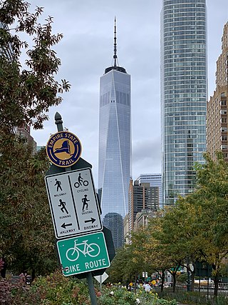
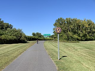
The Empire State Trail is a multi-use trail in New York State that was proposed by Governor Andrew Cuomo in January 2017 and completed in December 2020. The trail runs from Manhattan north to the Canada–United States border in Rouses Point near the northern tip of Lake Champlain, and also from Buffalo to Albany. At 750 miles (1,210 km), it is the longest multi-use trail in the United States. The trail includes pre-existing trail segments, which retain their existing identity but are now co-signed as a segment of the Empire State Trail. The trail also links to other regional bicycling and hiking trails such as the Appalachian Trail, the Adirondack and Catskill Parks, the Great Lakes Seaway Trail, the Genesee Valley Greenway, and others. A segment near its southernmost part, on the Hudson River Greenway in Manhattan, is concurrent with the East Coast Greenway. The trail is used for hiking, biking, snowshoeing, cross-country skiing and in some areas snowmobiling.
The Albany County Helderberg-Hudson Rail Trail is a 9.8 mile rail trail in Albany County, New York. Starting in the South End of the city of Albany, it connects to the communities of Delmar and Slingerlands before ending in the village of Voorheesville. In Albany, the trail directly connects to the South End Bikeway, which connects to Downtown Albany and the Mohawk-Hudson Bike-Hike Trail - a part of both the Erie Canalway Trail and Empire State Trail systems.