Oswego Recreational Trail

Last updated

The Oswego County Recreation Trail is a multi-use rail trail in New York.

Rail trail railroad bed converted to a recreational trail

A rail trail is the conversion of a disused railway track into a multi-use path, typically for walking, cycling and sometimes horse riding and snowmobiling. The characteristics of abandoned railways—flat, long, frequently running through historical areas—are appealing for various developments. The term sometimes also covers trails running alongside working railways; these are called "rails with trails". Some shared trails are segregated, with the segregation achieved with or without separation. Many rail trails are long-distance trails.

New York (state) State of the United States of America

New York is a state in the Northeastern United States. New York was one of the original thirteen colonies that formed the United States. With an estimated 19.54 million residents in 2018, it is the fourth most populous state. In order to distinguish the state from the city with the same name, it is sometimes referred to as New York State.

The Oswego Recreational Trail actually comprises two trails which are separated by an on-road section. It follows the route of the former New York, Ontario and Western Railway, abandoned in 1957.

New York, Ontario and Western Railway Abandoned northeastern railroad

The New York, Ontario and Western Railway, more commonly known as the O&W or NYO&W, was a regional railroad with origins in 1868, lasting until March 29, 1957 when it was ordered liquidated by a US bankruptcy judge. It was the first notable U.S. railroad with its mainline entirely abandoned.

The east portion runs 10 miles (16 km) from the city of Fulton's Maple Avenue to the village of Central Square, just short of Interstate 81. I-81 was built following the NYO&W abandonment and no provision was made to preserve the railroad right-of-way by creating a grade separation.

Fulton, Oswego County, New York City in New York, United States

Fulton is a small city in the western part of Oswego County, New York. The population was 11,896 as of the 2010 census. The city is named after Robert Fulton, the inventor of the steamboat.

Central Square, New York Village in New York, United States

Central Square is a village in Oswego County, New York, United States. The population was 1,848 at the 2010 census.

Interstate 81 (I-81) is a part of the Interstate Highway System that runs from Interstate 40 at Dandridge, Tennessee, to the Thousand Islands International Bridge at Wellesley Island in New York, beyond which a short stub links it to Ontario Highway 401. In the U.S. state of New York, I-81 extends 183.62 miles (295.51 km) from the Pennsylvania state line southeast of Binghamton to the Canadian border at Wellesley Island northwest of Alexandria Bay. The freeway runs north–south through Central New York, serving the cities of Binghamton, Syracuse, and Watertown. It passes through the Thousand Islands in its final miles and crosses two bridges, both part of the series of bridges known as the Thousand Islands Bridge.

To get around I-81, you must travel on roads through Central Square. North on U.S. Route 11, east on New York State Route 49 across I-81, and south on County Route 37 takes you back to the trail. At that point, the trail to the west (back towards I-81) is ridable, but it ends at a creek where the railroad bridge has been removed. Once back on the trail, it is 16 miles (26 km) to Cleveland and the Oneida County line. The right-of-way continues as a privately owned trail, open for some uses.

U.S. Route 11 in New York highway in New York

U.S. Route 11 (US 11) is a part of the U.S. Highway System that runs from New Orleans, Louisiana, to the Canada–US border at Rouses Point, New York. In the state of New York, US 11 extends for 318.66 miles (512.83 km) from the Pennsylvania state line south of the Southern Tier city of Binghamton to the Canada–US border at the North Country village of Rouses Point, where it becomes Route 223 upon entering Quebec. The portion of US 11 south of Watertown follows a mostly north–south alignment and is paralleled by Interstate 81 (I-81) while the part of the route north of Watertown follows a more east–west routing, parallel to but not directly on the St. Lawrence River.

New York State Route 49 highway in New York

New York State Route 49 (NY 49) is an east–west state highway in central New York in the United States. It runs for just over 64 miles (103 km) from an intersection with NY 3 in the town of Volney to an interchange with Interstate 790 (I-790), NY 5, NY 8 and NY 12 in the city of Utica. The route follows a generally northwest–southeast alignment between the two points, passing along the north shore of Oneida Lake and directly serving the city of Rome. As NY 49 heads east, it connects to several highways of regional importance, such as I-81 in the village of Central Square and NY 13 in the town of Vienna. Most of NY 49 is a two-lane surface road; however, the section between Rome and Utica is a freeway known as the Utica–Rome Expressway.

Cleveland, New York Village in New York, United States

Cleveland is a village in Oswego County, New York, United States. The population was 750 at the 2010 census. The Village of Cleveland is located at the eastern boundary of the Town of Constantia on NY Route 49.

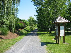
The trail has not been resurfaced except in a few eroded spots. The railroad used crushed rock ballast that remains as the surface of the trail. The trail crosses many steams on the original railroad bridges. They have been decked over with steel. Any road which crosses the trail may be used to gain access to the trail. Convenient parking is available at County Route 6, south of Fulton; on Toad Harbor Road, off Route 49, near Three Mile Bay; and in the village of Cleveland on North Street.

Track ballast trackbed upon which railroad ties are laid

Track ballast forms the trackbed upon which railroad ties (sleepers) are laid. It is packed between, below, and around the ties. It is used to bear the load from the railroad ties, to facilitate drainage of water, and also to keep down vegetation that might interfere with the track structure. This also serves to hold the track in place as the trains roll by. It is typically made of crushed stone, although ballast has sometimes consisted of other, less suitable materials, for example burnt clay. The term "ballast" comes from a nautical term for the stones used to stabilize a ship.

New York State Route 22 (NY 22) is a north–south state highway that parallels the eastern border of the U.S. state of New York, from the outskirts of New York City to the hamlet of Mooers in Clinton County near the Canadian border. At 337 miles (542 km), it is the state's longest north–south route and the third longest state route overall, after NY 5 and NY 17. Many of the state's major east–west roads intersect with, and often join, Route 22 just before crossing into the neighboring New England states, where U.S. Route 7 (US 7), which originally partially followed NY 22's alignment, similarly parallels the New York state line.

Three Mile Bay, New York Census-designated place in New York, United States

Three Mile Bay is a hamlet and census-designated place (CDP) in the town of Lyme in Jefferson County, New York, United States. The elevation is 259 feet (79 m). As of the 2010 census it had a population of 227.


Related Research Articles

Interstate 78 (I-78) is an Interstate Highway in the Northeast United States, running 144 miles (231 km) from Interstate 81 northeast of Harrisburg, Pennsylvania, through Allentown, Pennsylvania, and western and northern New Jersey to the Holland Tunnel and Lower Manhattan in New York City.

Interstate 481 (I-481) is an auxiliary Interstate Highway that serves as an eastern bypass of Syracuse, New York, in the United States. It begins at its parent, I-81, in the city's southern end and travels through the eastern Syracuse suburbs of Jamesville, DeWitt, and Cicero before rejoining I-81 in the suburb of North Syracuse. After crossing I-81 in North Syracuse, I-481 continues northwest to Fulton and Oswego as New York State Route 481 (NY 481). I-481 is part of the Veterans Memorial Highway, which extends northward onto NY 481.

New York State Route 104 highway in New York

New York State Route 104 (NY 104) is a 182.41-mile (293.56 km) long east–west state highway in Upstate New York in the United States. It spans six counties and enters the vicinity of four cities—Niagara Falls, Lockport, Rochester, and Oswego—as it follows a routing largely parallel to the southern shoreline of Lake Ontario, along a ridge of the old shoreline of Glacial Lake Iroquois. The western terminus of NY 104 is an intersection with NY 384 in Niagara Falls, Niagara County, while its eastern terminus is a junction with NY 13 in the town of Williamstown, Oswego County. The portion of NY 104 between Rochester and the village of Webster east of the city is a limited-access highway known as the Keeler Street Expressway west of NY 590 and the Irondequoit–Wayne County Expressway east of NY 590; from Williamson to Oswego, NY 104 is a super two highway.

New York State Route 48 highway in New York

New York State Route 48 (NY 48) is a 28.20-mile (45.38 km) north–south state highway in Central New York in the United States. The southern terminus of the route is located at Interstate 690 (I-690) exit 3 near the interchange between I-690 and the New York State Thruway (I-90) in Van Buren, northwest of Syracuse. The northern terminus is located at an intersection with NY 104 in Oswego. In between, NY 48 passes through the riverside communities of Baldwinsville and Fulton and runs alongside both the Seneca River and Oswego River. For most of its route, NY 48 serves as an alternate route of NY 481. The routes share similar alignments along the Oswego River from the Syracuse area to Oswego, with NY 481 following the eastern riverbank between the two locations.

Mount Hood Highway highway in Oregon

The Mount Hood Highway No. 26 is the Oregon Department of Transportation's designation for a 93.84-mile (151.02 km) highway from Portland east around the south side of Mount Hood and north via Bennett Pass to Hood River. It is marked as U.S. Route 26 from Portland to near Mount Hood and Oregon Route 35 the rest of the way to Hood River.

This is a list of trails in Ithaca, New York.

U.S. Route 90 in Louisiana highway in Louisiana

U.S. Highway 90 in Louisiana , one of the major east–west U.S. Highways in the Southern United States, runs through southern Louisiana for 297.6 miles (478.9 km), serving Lake Charles, Lafayette, New Iberia, Morgan City, and New Orleans. Much of it west of Lafayette and east of New Orleans has been supplanted by Interstate 10 (I-10) for all but local traffic, but the section between Lafayette and New Orleans runs a good deal south of I-10.

New York State Route 104A highway in New York

New York State Route 104A (NY 104A) is a northeast–southwest state highway in the central portion of New York in the United States. It serves as a northerly alternate route of NY 104, to which it connects at each end. The route extends for 17.38 miles (27.97 km) from an intersection with NY 104 and NY 370 south of the village of Red Creek to a junction with NY 104 southwest of the city of Oswego. NY 104A spans three counties, serves two villages and parallels Lake Ontario for much of its length. All of NY 104A is part of the Seaway Trail, a National Scenic Byway.

Air Line State Park Trail

The Air Line State Park Trail is a rail trail and linear state park located in Connecticut. The trail is divided into sections designated South, North, and the Thompson addition. An additional 3.6 mile spur to Colchester is sometimes designated as part of the Air Line trail. At the Massachusetts state line, the trail connects to the Southern New England Trunkline Trail, a 22 mile long trail to Franklin, MA built on the same right-of-way. Since 2018, the town of Portland, CT has also maintained a 2.3 mile portion of the Airline Trail, connecting to the southern end of the state park at the town line with East Hampton.

Schuylkill River Trail

The Schuylkill River Trail is a multi-use trail along the banks of the Schuylkill River in southeastern Pennsylvania. Partially complete as of 2018, the trail is ultimately planned to run about 140 miles (230 km) from the river's headwaters in Schuylkill County to Fort Mifflin in Philadelphia.

New York State Route 176 highway in New York

New York State Route 176 (NY 176) is a north–south state highway located in the central part of New York, in the United States, that connects Cayuga County with Oswego County. The southern terminus of the route is at an intersection with NY 370 in the northeast part of the town of Cato, east of Meridian. Its northern terminus is at a junction with NY 48 in the city of Fulton.

Ridge Road (Western New York)

Ridge Road is a 121.5-mile (195.5 km) east–west road that traverses four counties in Upstate New York in the United States. The road begins adjacent to the Niagara River at an intersection with Water Street in Lewiston, Niagara County, and passes through several towns, villages, and the city of Rochester before arriving at its eastern terminus at a junction with New York State Route 370 (NY 370) southwest of Red Creek, Wayne County. It is named for the rise atop which the road was built, a mound of sand and gravel that was formed when it was the shoreline of ancient Glacial Lake Iroquois. The ridge is often confused with the nearby Niagara Escarpment, which is much taller, geologic in origin, and lies a few miles to the south.

New York State Route 481 highway in New York

New York State Route 481 (NY 481) is a state highway in Central New York in the United States. The southern terminus of the route is at an interchange with Interstate 81 (I-81) in North Syracuse, where the highway continues southeastward as I-481. Its northern terminus is located at an intersection with NY 104 in Oswego about two blocks from Lake Ontario. In between, NY 481 serves the communities of Clay, Phoenix and Fulton along the Oswego River. NY 481 is one of two state routes in the Syracuse area that serves as an extension of an Interstate Highway; the other is NY 690.

Moosup Valley State Park Trail

The Moosup Valley State Park Trail is a rail trail located on the railbed of a former New York, New Haven and Hartford Railroad line in the New England towns of Plainfield and Sterling in Windham County, Connecticut. The line ran from 1898 until 1968. The rail line was abandoned in the late 1960s, and was designated by the state as a multi-use trail in 1987. The trail is owned and operated by the Connecticut Department of Energy and Environmental Protection.

Cape Cod Rail Trail

The Cape Cod Rail Trail (CCRT) is a 22-mile (35 km) paved rail trail located on Cape Cod in Massachusetts. The trail route passes through the towns of Dennis, Harwich, Brewster, Orleans, Eastham, and Wellfleet. It connects to the 6-plus mile (10 km) Old Colony Rail Trail leading to Chatham and 8 miles (13 km) of trails within Nickerson State Park. Short side trips on roads lead to national seashore beaches including Coast Guard Beach at the end of the Nauset Bike Trail in Cape Cod National Seashore.

U.S. Route 90 in Florida highway in Florida

U.S. Route 90 in the State of Florida is the northernmost west-to-east U.S. route in the state although it is one of the southernmost U.S. west-to-east routes in the rest of the United States. Highway 90 passes through the county seats of all 15 counties on its course in Florida, and is also the road upon which many of the county courthouses are located. It is never more than six miles (10 km) from I-10 throughout the state. It runs as a two-lane highway through most of the sparsely populated inland areas of the panhandle, becoming four-lanes through and near several towns. The speed limit is 55 mph (89 km/h) for all rural points west of Monticello, and it is 60 mph (97 km/h) on all rural points beginning in Madison County to Glen St. Mary.

New York State Route 57 former highway in New York

New York State Route 57 (NY 57) was a north–south state highway in the central portion of New York in the United States. It extended for 33.45 miles (53.83 km) from an intersection with U.S. Route 11 (US 11) just north of downtown Syracuse to a junction with NY 104 six blocks from the Lake Ontario shoreline in Oswego. North of Liverpool, NY 57 was routed along the eastern bank of the Seneca and Oswego Rivers. It passed through several riverside communities, including the village of Phoenix and the city of Fulton. The route largely paralleled NY 48, which follows the western bank of the waterway between Van Buren and Oswego via Baldwinsville.

The Auburn Trail is a multi-use rail trail located principally in the towns of Victor and Farmington, Ontario County, New York (USA). It is approximately 11 miles (18 km) long and maintained by the Towns of Victor and Farmington and Victor Hiking Trails. The trail mostly follows the alignment of the Auburn and Rochester Railroad. Additional disconnected portions of the Auburn trail are found in the Towns of Pittsford and Brighton, Monroe County, NY. A detailed description and map of the Auburn Trail are available from Victor Hiking Trails.