Joseph B. Clarke Rail Trail

Last updated
Joseph B. Clarke Rail Trail
Joseph B Clarke Rail Trail.jpg
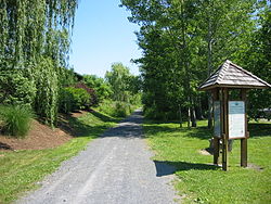
Joseph B. Clarke Rail Trail in Tappan, New York.
Length3.8 mi (6.1 km)
Location Rockland County, New York
Trailheads Blauvelt Library at Western Highway in Blauvelt
41°03′35″N73°57′27″W / 41.05964°N 73.95739°W / 41.05964; -73.95739 (Joseph B. Clarke Rail Trail (northern trailhead))
Oak Tree Road in Tappan
41°01′02″N73°56′22″W / 41.01731°N 73.93935°W / 41.01731; -73.93935 (Joseph B. Clarke Rail Trail (southern trailhead))
UseWalking & Biking

The Joseph B. Clarke Rail Trail is a paved 3.8 mile north-south rail trail in the town of Orangetown, Rockland County, New York. It begins at the Blauvelt Free Library on Western Highway in the hamlet of Blauvelt, and ends at the intersection of Oak Tree Road in the hamlet of Tappan. The trail intersects the Old Erie Path at Depot Square in Sparkill. [1]

The trail follows the right-of-ways of two former railroads. From the southern trailhead in Tappan to Sparkill, it follows the Northern Branch, which was constructed in 1859 by the Northern Railroad of New Jersey from Nyack to Pavonia Terminal in Jersey City. The railway's right-of-way continues north from Sparkill as the Old Erie Path. Northwest of Sparkill, the trail follows the right-of-way of the old Erie Main Line (also known as the Piermont Line) of the Erie Railroad. [2] [3]

The Old Erie Path to Nyack splits off from the Clarke Trail to Blauvelt in Sparkill Clarke Trail Junction.jpg
The Old Erie Path to Nyack splits off from the Clarke Trail to Blauvelt in Sparkill

Related Research Articles

<span class="mw-page-title-main">Rockland County, New York</span> County in New York, United States

Rockland County is the second-southernmost county on the west side of the Hudson River in the U.S. state of New York, after Richmond County. It is part of the New York metropolitan area. As of the 2020 U.S. census, the county's population is 338,329, making it the state's third-most densely populated county outside New York City after Nassau and neighboring Westchester Counties. The county seat and largest city is New City. Rockland County is accessible via the New York State Thruway, which crosses the Hudson to Westchester at the Tappan Zee Bridge ten exits up from the NYC border, as well as the Palisades Parkway five exits up from the George Washington Bridge. The county's name derives from "rocky land", as the area has been aptly described, largely due to the Hudson River Palisades.

<span class="mw-page-title-main">Nyack, New York</span> Village in New York, United States

Nyack is a village located primarily in the town of Orangetown in Rockland County, New York, United States. Incorporated in 1872, it retains a very small western section in Clarkstown. The village had a population of 7,265 as of the 2020 census. It is a suburb of New York City lying approximately 15 miles (24 km) north of the Manhattan boundary near the west bank of the Hudson River, situated north of South Nyack, east of Central Nyack, south of Upper Nyack, and southeast of Valley Cottage.

<span class="mw-page-title-main">Orangetown, New York</span> Town in New York, United States

Orangetown is a town in Rockland County, New York, United States, located in the southeastern part of the county. It is northwest of New York City, north of New Jersey, east of the town of Ramapo, south of the town of Clarkstown, and west of the Hudson River. The population was 48,655 at the 2020 census.

<span class="mw-page-title-main">Piermont, New York</span> Village in New York, United States

Piermont is a village incorporated in 1847 in Rockland County, New York, United States. Piermont is in the town of Orangetown, located north of the hamlet of Palisades, east of Sparkill, and south of Grand View-on-Hudson, on the west bank of the Hudson River. The population was 2,517 at the 2020 census. Woody Allen set The Purple Rose of Cairo, a fictional film within The Purple Rose of Cairo (1984) in Piermont.

<span class="mw-page-title-main">South Nyack, New York</span> Hamlet in New York, United States

South Nyack is a hamlet and census-designated place in the town of Orangetown in Rockland County, New York, United States. It is located north of Grand View-on-Hudson, northeast of Orangeburg, east of Blauvelt State Park, south of Nyack and west of the Hudson River. The hamlet is the western terminus of the Tappan Zee Bridge. Its population was 3,510 at the 2010 census. The hamlet was formerly incorporated as a village from 1878 until 2022.

<span class="mw-page-title-main">Tappan, New York</span> Census-designated place in New York, United States

Tappan is a hamlet and census-designated place in the town of Orangetown, Rockland County, New York. It is located northwest of Alpine, New Jersey, north of Northvale, New Jersey and Rockleigh, New Jersey, northeast of Old Tappan, New Jersey, east/southeast of Nauraushaun and Pearl River, south of Orangeburg, southwest of Sparkill, and west of Palisades; Tappan shares a border with each. The population was 6,673, according to the 2020 census.

<span class="mw-page-title-main">Northern Branch</span>

The Northern Branch is a railroad line that runs from Jersey City to Northvale in northeastern New Jersey, and formerly extended further into New York State. The line was constructed in 1859 by the Northern Railroad of New Jersey to connect the New York and Erie Railroad's Piermont Branch terminus in Piermont, New York, directly to Erie's primary terminal in Jersey City, initially Exchange Place, later Pavonia Terminal. In 1870 the line was extended to Nyack, New York, and continued to provide passenger service until 1966. After the Erie's unsuccessful merger with the Lackawanna Railroad to form the Erie-Lackawanna, ownership of the line passed into the hands of Conrail upon its formation in 1976 from a number of bankrupt railroads.

<span class="mw-page-title-main">Blauvelt State Park</span> State park in Rockland County, New York

Blauvelt State Park is a 644-acre (2.61 km2) undeveloped state park located in the Town of Orangetown in Rockland County, New York, near the Hudson River Palisades. The park's land occupies the site of the former Camp Bluefields, a rifle range used to train members of the New York National Guard prior to World War I. The park is located south of Nyack.

The West Shore Railroad was the final name of a railroad that ran from Weehawken, New Jersey, on the west bank of the Hudson River opposite New York City, north to Albany, New York, and then west to Buffalo. It was organized as a competitor to the New York Central and Hudson River Railroad, but was soon taken over by that company.

<span class="mw-page-title-main">Hockhocking Adena Bikeway</span>

The Hockhocking Adena Bikeway, known colloquially as The Bike Path or more formally as The Athens County Bike Path, is a 22-mile (35 km) long bicycle path in Athens County, Ohio, in the United States. The original section of the path was built on a levee along the Hocking River at Ohio University in Athens, on university land. It was gradually expanded and now crosses university land, city land, and county land. The greater part of the path is a rail trail,. The eastern terminus is at the western intersection of South Canaan Road and US-50. The western terminus is in Nelsonville, at the Rocky Brands Factory Outlet at the intersection of Canal Street and Myers Street, one block from the Historic Square Arts District.

<span class="mw-page-title-main">Sparkill, New York</span> Census-designated place in New York, United States

Sparkill, formerly known as Tappan Sloat, is a suburban hamlet and census-designated place in the Town of Orangetown, Rockland County, New York, United States located north of Palisades; east of Tappan; south of Piermont and west of the Hudson River. As of the 2010 census, the CDP had a population of 1,565. The hamlet is home to St. Thomas Aquinas College and the Dominican Sisters of Sparkill.

<span class="mw-page-title-main">New York State Route 340</span> State highway in Rockland County, New York, US

New York State Route 340 (NY 340) is a 3.10-mile (4.99 km) state highway in southeastern Rockland County, New York, in the United States. Though it is signed as an east–west route, it actually follows a north–south alignment. The southern terminus of the route is at the New Jersey state line in Palisades, where it becomes County Route 501 (CR 501). The northern terminus is at an intersection with NY 303 in Orangeburg; however, according to the New York State Department of Transportation (NYSDOT), the route continued for another 0.07 miles (0.11 km) to the northwest of NY 303 until by 2017. NY 340 was assigned to part of its modern routing in the early 1930s and extended to its current length in the early 1940s.

<span class="mw-page-title-main">New York State Route 303</span> State highway in Rockland County, New York, US

New York State Route 303 (NY 303) is a north–south state highway in eastern Rockland County, New York, in the United States. It begins at the New Jersey state line in the hamlet of Tappan and runs generally northward for 10.92 miles (17.57 km) to an intersection with U.S. Route 9W (US 9W) in Clarkstown. The route has connections to the Palisades Interstate Parkway and the New York State Thruway, the latter carrying Interstate 87 (I-87) and I-287. NY 303 was assigned as part of the 1930 renumbering of state highways in New York, and only minor realignments have occurred since that time.

<span class="mw-page-title-main">Piermont station</span>

Piermont Railroad Station is a historic train station located at Piermont in Rockland County, New York. It was built about 1873 by the Northern Railroad of New Jersey, later acquired by the Erie Railroad. It is a 1+12-story, light frame building above a stone foundation. It features Stick Style exterior siding and a Late Victorian interior.

The recorded history of Rockland County, New York begins on February 23, 1798, when the county was split off from Orange County, New York and formed as its own administrative division of the state of New York. It is located 6 miles (9.7 km) north-northwest of New York City, and is part of the New York Metropolitan Area. The county seat is the hamlet of New City. The name comes from rocky land, an early description of the area given by settlers. Rockland is New York's southernmost county west of the Hudson River. It is suburban in nature, with a considerable amount of scenic designated parkland. Rockland County does not border any of the New York City boroughs, but is only 9.5 miles (15.3 km) north of Manhattan at the counties' two respective closest points

<span class="mw-page-title-main">Sparkill Creek</span> River in New Jersey, United States

Sparkill Creek, is a tributary of the Hudson River in Rockland County, New York and Bergen County, New Jersey in the United States. It flows through the Sparkill Gap in the Hudson Palisades, which was created by a fault line which provided the only sea-level break in the Palisades.

<span class="mw-page-title-main">Old Erie Path</span>

The Old Erie Path is a 3.4 mile north-south rail trail in the town of Orangetown, Rockland County, New York. It begins at the southern edge of South Nyack at the end of the Raymond G. Esposito Trail, spanning Grand View-on-Hudson and Piermont before terminating at the junction of the Joseph B. Clarke Rail Trail in Sparkill. The trail is a dirt path, suitable for hiking and mountain biking.

<span class="mw-page-title-main">Raymond G. Esposito Trail</span>

The Raymond G. Esposito Trail is a 1.1 mile north-south rail trail located in the village of South Nyack, Rockland County, New York. It begins at Franklin Street Park at the corner of Cedar Hill Road and Franklin Avenue on the border of Nyack and South Nyack, which was the site of the original Nyack station, and continues as the Old Erie Path upon crossing the border into Grand View-on-Hudson. The trail takes its name from Raymond Esposito, a long-time village official who died in 1986.

The Erie Railroad Piermont Branch was a rail branch line that was formed from the easternmost portion of the original main line of the Erie. It ran from Suffern, New York to Piermont, New York.

References