Raymond G. Esposito Trail

Last updated
Raymond G. Esposito Trail
Raymond G Esposito Trail.jpg
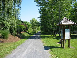
Esposito Trail in South Nyack, New York.
Length3.4 mi (5.5 km)
Location Rockland County, New York
Trailheads Franklin Street Park in Nyack
41°05′16″N73°55′18″W / 41.08788°N 73.92172°W / 41.08788; -73.92172 (Raymond G. Esposito Trail (northern trailhead))
Old Erie Path in Grand View-on-Hudson
41°04′25″N73°55′22″W / 41.07361°N 73.92264°W / 41.07361; -73.92264 (Raymond G. Esposito Trail (southern trailhead))
UseHiking & Mountain Biking
Map all coordinates using: OpenStreetMap  
Download coordinates as: KML  ·  GPX

The Raymond G. Esposito Trail is a 1.1 mile north-south rail trail located in the village of South Nyack, Rockland County, New York. It begins at Franklin Street Park at the corner of Cedar Hill Road and Franklin Avenue on the border of Nyack and South Nyack, which was the site of the original Nyack station, and continues as the Old Erie Path upon crossing the border into Grand View-on-Hudson. [1] The trail takes its name from Raymond Esposito, a long-time village official who died in 1986. [2]

The trail follows the former Northern Branch, which was originally constructed in 1859 by the Northern Railroad of New Jersey from Nyack to Pavonia Terminal in Jersey City. In 1942, the Northern Railroad of New Jersey was sold to the Erie Railroad, where it was known as the Northern Branch until passenger service ceased in 1966. [3]

Related Research Articles

Rockland County, New York County in New York

Rockland County is the southernmost county on the west side of the Hudson River in the U.S. state of New York, part of the New York City Metropolitan Statistical Area. It is a suburb of New York City that is about 6 miles from The Bronx at their closest points. The county's population, as of the 2010 United States Census, was 311,687, increasing to a 2019 Census estimate of 325,789, making it the third-most densely populated county outside New York City within New York State. The county seat is New City. Rockland County is accessible via the New York State Thruway, 9 exits up from The Bronx, as well as the Palisades Parkway, 5 exits up from the George Washington Bridge. The name derives from "rocky land", as the area has been aptly described.

Nyack, New York Village in New York, United States

Nyack is a village located primarily in the town of Orangetown in Rockland County, New York, United States. Incorporated in 1872, it retains a very small western section in Clarkstown. It is an inner suburb of New York City lying approximately 19 miles (31 km) north of the Manhattan boundary near the west bank of the Hudson River, situated north of South Nyack, east of Central Nyack, south of Upper Nyack, and southeast of Valley Cottage.

South Nyack, New York Village in New York, United States

South Nyack is a village incorporated in 1878 in the town of Orangetown in Rockland County, New York, in the United States. It is located north of Grand View-on-Hudson, northeast of Orangeburg, east of Blauvelt State Park, south of Nyack and west of the Hudson River. The village is the western terminus of the Tappan Zee Bridge. Its population was 3,510 at the 2010 census.

New York State Route 17 (NY 17) is a major state highway that extends for 397 miles (638.91 km) through the Southern Tier and Downstate regions of New York in the United States. It begins at the Pennsylvania state line in Mina and follows the Southern Tier Expressway east through Corning to Binghamton and the Quickway from Binghamton east to Woodbury, where it turns south to follow the Orange Turnpike to the New Jersey state line near Suffern, where it connects to New Jersey Route 17. From the Pennsylvania border to the village of Waverly and from Binghamton to Windsor, NY 17 is concurrent with Interstate 86 (I-86). Eventually, the entire east–west portion of NY 17 from the Pennsylvania border to Woodbury will become I-86 as projects to upgrade the route to Interstate Highway standards are completed.

New York, Susquehanna and Western Railway

The New York, Susquehanna and Western Railway is a Class II American freight railway operating over 400 miles (645 km) of track in the northeastern U.S. states of New York, Pennsylvania, and New Jersey.

Hoboken Terminal Commuter station in Hoboken, New Jersey

Hoboken Terminal is a commuter-oriented intermodal passenger station in Hoboken, Hudson County, New Jersey, United States. One of the New York metropolitan area's major transportation hubs, it is served by nine NJ Transit (NJT) commuter rail lines, one Metro-North Railroad line, various NJT buses and private bus lines, the Hudson–Bergen Light Rail, the Port Authority Trans Hudson (PATH) rapid transit system, and NY Waterway-operated ferries. More than 50,000 people use the terminal daily, making it the ninth-busiest railroad station in North America and the sixth-busiest in the New York area. It is also the second-busiest railroad station in New Jersey, behind only Newark Penn Station, and its third-busiest transportation facility, after Newark Liberty International Airport and Newark Penn. Hoboken Terminal is wheelchair accessible, with high-level platforms for light rail and PATH services and portable lifts for commuter rail services.

Lake Shore and Michigan Southern Railway

The Lake Shore and Michigan Southern Railway, established in 1833 and sometimes referred to as the Lake Shore, was a major part of the New York Central Railroad's Water Level Route from Buffalo, New York, to Chicago, Illinois, primarily along the south shore of Lake Erie and across northern Indiana. The line's trackage is still used as a major rail transportation corridor and hosts Amtrak passenger trains, with the ownership in 1998 split at Cleveland between CSX to the east, and Norfolk Southern in the west.

Timeline of Jersey City, New Jersey-area railroads

For the purposes of this article, the Jersey City area extends North to Edgewater, South to Bayonne and includes Kearny Junction and Harrison but not Newark. Many routes east of Newark are listed here.

The Northern Branch is a railroad line that runs from Jersey City to Northvale in northeastern New Jersey. The line was constructed in 1859 by the Northern Railroad of New Jersey to connect the New York and Erie Rail Road's Piermont Branch terminus in Piermont, New York, to Erie's Pavonia Terminal in Jersey City. The line was then extended to Nyack, New York in 1870 and provided passenger service until 1966. Ownership of the line passed into the hands of Conrail upon the its formation in 1976.

Columbia Trail

The Columbia Trail is a rail trail in rural northwestern New Jersey. It was created from portions of the former Central Railroad of New Jersey High Bridge Branch and stretches from High Bridge, in Hunterdon County, through Washington Township, in Morris County for a total of 15.1 miles (24.3 km). The trail surface is relatively flat and consists mostly of fine crushed stone.

Pavonia Terminal

Pavonia Terminal was the Erie Railroad terminal on the Hudson River situated on the landfilled Harsimus Cove in Jersey City, New Jersey. The station opened in 1861 and closed in 1958 when the Erie Railroad moved its passenger services to nearby Hoboken Terminal. The New York, Susquehanna and Western Railway also ran commuter trains from the terminal and various street cars, ferries and the underground Hudson and Manhattan Railroad serviced the station. The station was abandoned in 1958 and demolished in 1961.

Mountain View station

Mountain View, signed on the platform as Mountain View–Wayne, is a station on the Montclair-Boonton Line of NJ Transit in Wayne, New Jersey. Prior to the Montclair Connection in 2002, the station was served by the Boonton Line. The station is located on Erie Avenue, just off of US 202 and Route 23 in Downtown Wayne. Since January 2008, Mountain View station is the second of two stations in Wayne, the other being the Wayne Route 23 Transit Center, a station off the Westbelt interchange.

Ridgewood station

Ridgewood is a railroad station operated by New Jersey Transit in the village of Ridgewood, Bergen County, New Jersey, United States. A major transfer station, Ridgewood has two high-level platforms for the Main Line and Bergen County Line.

Weehawken Terminal

Weehawken Terminal was the waterfront intermodal terminal on the North River in Weehawken, New Jersey for the New York Central Railroad's West Shore Railroad division, whose route travelled along the west shore of the Hudson River. It opened in 1884 and closed in 1959. The complex contained five ferry slips, sixteen passenger train tracks, car float facilities, and extensive yards. The facility was also used by the New York, Ontario and Western Railway. The terminal was one of five passenger railroad terminals that lined the Hudson Waterfront during the 19th and 20th centuries, the others were located at Hoboken, Pavonia, Exchange Place and Communipaw, with Hoboken being the only one still in use.

Piermont station

Piermont Railroad Station is a historic train station located at Piermont in Rockland County, New York. It was built about 1873 by the Northern Railroad of New Jersey, later acquired by the Erie Railroad. It is a ​1 12-story, light frame building above a stone foundation. It features Stick Style exterior siding and a Late Victorian interior.

South Nyack was a railroad station on the Erie Railroad Northern Branch in South Nyack, New York. The station opened on May 21, 1870, and closed on December 14, 1965, when the Erie-Lackawanna Railroad, successor to the Erie, ended all service north of Sparkill. It was razed in 1970.

Old Erie Path

The Old Erie Path is a 3.4 mile north-south rail trail in the town of Orangetown, Rockland County, New York. It begins at the southern edge of South Nyack at the end of the Raymond G. Esposito Trail, spanning Grand View-on-Hudson and Piermont before terminating at the junction of the Joseph B. Clarke Rail Trail in Sparkill. The trail is a dirt path, suitable for hiking and mountain biking.

Joseph B. Clarke Rail Trail

The Joseph B. Clarke Rail Trail is a paved 3.8 mile north-south rail trail in the town of Orangetown, Rockland County, New York. It begins at the Blauvelt Free Library on Western Highway in the hamlet of Blauvelt, and ends at the intersection of Oak Tree Road in the hamlet of Tappan. The trail intersects the Old Erie Path at Depot Square in Sparkill.

Pompton–Riverdale station

Pompton–Riverdale is a former railroad station in the borough of Riverdale. Morris County, New Jersey, United States. Located at 13 Pompton–Hamburg Turnpike, the station was a stop on the Greenwood Lake Division of the Erie Railroad. A single side platform station with two tracks, the current station was built in 1919. The next station to the north was Pompton Junction, where connections were available to the New York, Susquehanna and Western Railroad, another Erie Railroad subsidiary. The next station south was Pompton Plains.

The Erie Railroad Piermont Branch was a rail line that was part of the original main line of the Erie. It ran from Suffern, New York to Sparkill, New York, originally terminating at the Piermont pier. After the section in Piermont section was demolished, it ran with the Northern Branch from Sparkill to Nyack, New York.

References

  1. Old Erie Path & Esposito Trails
  2. Hays, Mike (9 May 2019). "Nyack People & Places: How the Esposito Trail Got Its Name". Nyack News and Views. Retrieved 19 October 2020.
  3. "COMMUTERS LOSE BID TO KEEP ERIE TRAINS", The New York Times, p. 58, October 3, 1966, retrieved June 7, 2010