Riverside, Suffolk County, New York

Last updated

Riverside, New York
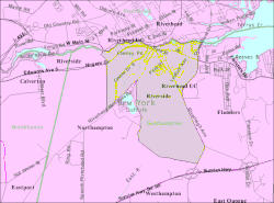
Riverside-uc-map.gif
U.S. Census map of Riverside.
USA New York location map.svg
Red pog.svg
Riverside
Location within the state of New York.
Coordinates: 40°54′28″N72°39′45″W / 40.90778°N 72.66250°W / 40.90778; -72.66250
Country Flag of the United States.svg  United States
State Flag of New York.svg  New York
County Suffolk
Town Southampton
Area
[1]
  Total2.75 sq mi (7.11 km2)
  Land2.65 sq mi (6.85 km2)
  Water0.10 sq mi (0.26 km2)
Population
 (2020)
  Total2,882
  Density1,088.78/sq mi (420.45/km2)
Time zone UTC-5 (Eastern (EST))
  Summer (DST) UTC-4 (EDT)
ZIP code
11901
Area code(s) 631, 934
FIPS code 36-62066

Riverside is a hamlet and census-designated place (CDP) in Suffolk County, New York, United States. The population was 2,911 at the 2010 census. [2]

Contents

Riverside is in the Town of Southampton and derives its name from being on the south bank of the Peconic River.

Geography

According to the United States Census Bureau, the CDP has a total area of 2.8 square miles (7.3 km2), of which 2.7 square miles (7.0 km2) is land and 0.12 square miles (0.3 km2), or 4.00%, is water. [2] [3]

Demographics

Historical population
CensusPop.Note
2020 2,882
U.S. Decennial Census [4]

At the 2000 census, [5] there were 2,875 people, 846 households and 485 families residing in the CDP. The population density was 563.4 inhabitants per square mile (217.5/km2). There were 926 housing units at an average density of 181.5 per square mile (70.1/km2). The racial makeup of the CDP was 59.10% White, 35.58% African American, 1.08% Native American, 0.73% Asian, 1.36% from other races, and 2.16% from two or more races. Hispanic or Latino of any race were 9.67% of the population.

There were 846 households, of which 20.6% had children under the age of 18 living with them, 36.8% were married couples living together, 16.7% had a female householder with no husband present, and 42.6% were non-families. 36.5% of all households were made up of individuals, and 22.0% had someone living alone who was 65 years of age or older. The average household size was 2.25 and the average family size was 2.90.

14.5% of the population were under the age of 18, 13.0% from 18 to 24, 36.3% from 25 to 44, 18.3% from 45 to 64, and 17.8% who were 65 years of age or older. The median age was 37 years. For every 100 females, there were 144.9 males. For every 100 females age 18 and over, there were 151.2 males.

The median household income was $28,208 and the median family income was $35,724. Males had a median income of $27,857 compared with $28,103 for females. The per capita income for the CDP was $13,428. About 20.0% of families and 21.0% of the population were below the poverty line, including 30.0% of those under age 18 and 10.7% of those age 65 or over.

Related Research Articles

<span class="mw-page-title-main">El Cerrito, Riverside County, California</span> Census-designated place in Riverside County, California, United States

El Cerrito is a census-designated place (CDP) in Riverside County, California, United States. It is an unincorporated area mostly surrounded by the city of Corona. The population was 5,100 at the 2010 census, up from 4,590 at the 2000 census.

<span class="mw-page-title-main">Mira Loma, California</span> Former census-designated place in California, United States

Mira Loma, now officially part of Jurupa Valley, was a census-designated place (CDP) in Riverside County, California, United States. Its population was 21,930 in the 2010 census, up from 17,617 in the 2000 census.

<span class="mw-page-title-main">Valle Vista, California</span> Census-designated place in California, United States

Valle Vista is a census-designated place (CDP) in Riverside County, California, United States and is located in the San Jacinto Valley. Some areas of Valle Vista are considered to be part of both unincorporated San Jacinto and Hemet but have yet to be incorporated. The population was 11,036 at the 2010 census, up from 8,356 at the 2000 census.

<span class="mw-page-title-main">Corralitos, California</span> Census-designated place in California, United States

Corralitos is a census-designated place (CDP) in Santa Cruz County, California, United States. It is a rural area known for its agriculture of apples and strawberries, and its notable Corralitos Market and Sausage Co. Moreover, its location near the Pacific Ocean optimizes viticulture.

<span class="mw-page-title-main">Orosi, California</span> Census-designated place in California, United States

Orosi is a census-designated place (CDP) in Tulare County, California, United States. The population was 8,770 at the 2010 census, up from 7,318 at the 2000 census.

<span class="mw-page-title-main">Lake Asbury, Florida</span> Census-designated place in Florida, United States

Lake Asbury is an unincorporated community and census-designated place (CDP) in Clay County, Florida, United States. The population was 8,700 at the 2010 census, which calls it Asbury Lake.

<span class="mw-page-title-main">Silver Springs Shores, Florida</span> Census-designated place in Florida, United States

Silver Springs Shores is a census-designated place (CDP) in Marion County, Florida, United States. The population was 24,846 at the 2020 census. It is part of the Ocala Metropolitan Statistical Area.

<span class="mw-page-title-main">Coral Terrace, Florida</span> Census-designated place in Florida, United States

Coral Terrace is a suburban unincorporated community and census-designated place (CDP) in Miami-Dade County, Florida, United States. The population was 23,142 at the 2020 census, down from 24,376 in 2010.

<span class="mw-page-title-main">Honaunau-Napoopoo, Hawaii</span> Census-designated place in Hawaii, U.S.

Hōnaunau-Nāpōʻopoʻo is a census-designated place (CDP) in Hawaiʻi County, Hawaii, United States. The population was 2,416 at the 2020 census.

<span class="mw-page-title-main">Lakeland Village, California</span> Census-designated place in California, United States

Lakeland Village is a census-designated place (CDP) in Riverside County, California, United States. The population was 11,541 at the 2010 census, more than double the 5,626 reported at the 2000 census.

<span class="mw-page-title-main">Woodbridge (CDP), New Jersey</span> Populated place in Middlesex County, New Jersey, US

Woodbridge is an unincorporated community and census-designated place (CDP) within Woodbridge Township, in Middlesex County, in the U.S. state of New Jersey. As of the 2010 United States Census, the CDP's population was 19,265. Despite the similarity in the name of the CDP and the township, the two are not coextensive; the CDP occupies 15.7% of the township's 24.51 square miles (63.5 km2).

<span class="mw-page-title-main">Leisure Knoll, New Jersey</span> Populated place in Ocean County, New Jersey, US

Leisure Knoll is an unincorporated community and census-designated place (CDP) located within Manchester Township, in Ocean County, in the U.S. state of New Jersey. As of the 2010 United States Census, the CDP's population was 2,490.

<span class="mw-page-title-main">Fairview, Dutchess County, New York</span> Census-designated place in New York, United States

Fairview is a hamlet and census-designated place (CDP) in Dutchess County, New York, United States. The population was 5,515 at the 2010 census. It is part of the Poughkeepsie–Newburgh–Middletown, NY Metropolitan Statistical Area as well as the larger New York–Newark–Bridgeport, NY-NJ-CT-PA Combined Statistical Area.

<span class="mw-page-title-main">Belmont, Pennsylvania</span> Census-designated place in Pennsylvania, United States

Belmont is an unincorporated community and census-designated place (CDP) in Cambria County, Pennsylvania, United States. The population was 2,784 at the 2010 census.

<span class="mw-page-title-main">East Berwick, Pennsylvania</span> Census-designated place in Pennsylvania, United States

East Berwick is a census-designated place (CDP) in Salem Township, Luzerne County, Pennsylvania, United States. The population was 2,007 at the 2010 census.

<span class="mw-page-title-main">Santa Maria, Texas</span> Census-designated place in Texas, United States

Santa Maria is a census-designated place (CDP) in Cameron County, Texas, United States. The population was 733 at the 2010 census, down from 846 at the 2000 census. It is part of the Brownsville–Harlingen Metropolitan Statistical Area.

<span class="mw-page-title-main">Riverside, Utah</span> CDP in Utah, United States

Riverside is a census-designated place (CDP) in Box Elder County, Utah, United States. The population was 760 at the 2010 census.

<span class="mw-page-title-main">Tainter Lake, Wisconsin</span> CDP in Wisconsin, United States

Tainter Lake is a census-designated place (CDP) in part of the Town of Tainter, Dunn County, Wisconsin, and part of the Town of Red Cedar, Dunn County, Wisconsin, United States. The population was 2,550 at the 2020 census.

<span class="mw-page-title-main">West Seneca (CDP), New York</span> Census-designated place in New York, United States

West Seneca is a hamlet and census-designated place (CDP) in Erie County, New York, United States. The population was 44,711 at the 2010 census. It is part of the Buffalo–Niagara Falls Metropolitan Statistical Area. The CDP corresponds exactly to the area of the town of West Seneca.

Riverside is a census-designated place (CDP) in Umatilla County, Oregon, United States. The population was 189 at the 2000 census. It is part of the Pendleton–Hermiston Micropolitan Statistical Area.

References

  1. "ArcGIS REST Services Directory". United States Census Bureau. Retrieved September 20, 2022.
  2. 1 2 "Geographic Identifiers: 2010 Demographic Profile Data (G001): Riverside CDP, New York". U.S. Census Bureau, American Factfinder. Retrieved January 8, 2013.
  3. "US Gazetteer files: 2010, 2000, and 1990". United States Census Bureau. February 12, 2011. Retrieved April 23, 2011.
  4. "Census of Population and Housing". Census.gov. Retrieved June 4, 2016.
  5. "U.S. Census website". United States Census Bureau . Retrieved January 31, 2008.