Flanders, New York

Last updated
Flanders, New York
Big Duck.JPG
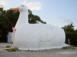
The iconic Big Duck along New York State Route 24 in Flanders.
Flanders-ny-map.gif
USA New York location map.svg
Red pog.svg
Flanders
Usa edcp location map.svg
Red pog.svg
Flanders
Coordinates: 40°54′18″N72°36′42″W / 40.90500°N 72.61167°W / 40.90500; -72.61167 Coordinates: 40°54′18″N72°36′42″W / 40.90500°N 72.61167°W / 40.90500; -72.61167
Country United States
State New York
County Suffolk
Town Southampton
Area
[1]
  Total12.38 sq mi (32.07 km2)
  Land11.50 sq mi (29.78 km2)
  Water0.88 sq mi (2.29 km2)
Elevation
7 ft (2 m)
Population
 (2020)
  Total5,098
  Density443.30/sq mi (171.17/km2)
Time zone UTC-5 (Eastern (EST))
  Summer (DST) UTC-4 (EDT)
ZIP code
11901
Area code 631
FIPS code 36-26121
GNIS feature ID0950227

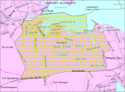
Flanders is a hamlet and a census-designated place (CDP) in Suffolk County, New York, United States. The population was 4,472 at the 2010 census. [2] It is the location of the Big Duck.

Contents

It is located in the town of Southampton on the south side of the Peconic River at its mouth in Peconic Bay. Riverhead is across the river to the north.

Geography

Flanders is located at 40°54′18″N72°36′42″W / 40.90500°N 72.61167°W / 40.90500; -72.61167 (40.905086, -72.611717). [3]

According to the United States Census Bureau, the CDP has a total area of 11.6 square miles (30.1 km2), of which 11.5 square miles (29.7 km2) is land and 0.15 square miles (0.4 km2), or 1.49%, is water. [2]

Demographics

Historical population
CensusPop.
2020 5,098
U.S. Decennial Census [4]

Demographics of the CDP

As of the census [5] of 2010, there were 4,705 people, 1,797 households, and 1,068 families residing in the CDP. The population density was 297.1 per square mile (114.7/km2). There were 1,797 housing units at an average density of 124.0/sq mi (47.9/km2). The racial makeup of the CDP was 25.63% White, 21.12% African American, 8.05% Native American, 1.04% Asian, 2.08% from other races, and 12.06% from two or more races. Hispanic or Latino of any race were 42.08% of the population.

There were 652 households that had children under the age of 18 living with them, 47.5% were married couples living together, 16.4% had a female householder with no husband present, and 29.4% were non-families. 21.5% of all households were made up of individuals, and 7.0% had someone living alone who was 65 years of age or older. The average household size was 3.28 and the average family size was 3.41.

In the CDP, the population was spread out, with 19% under the age of 18, 5.6% from 18 to 24, 52.7% from 15 to 44, 20.9% from 45 to 64, and 6,8% who were 65 years of age or older. The median age was 36.1 years. For every 100 females, there were 149.2 males.

The median income for a household in the CDP was $82,868, and the median income for a family was $69,615. Males had a median income of $46,844 versus $34,833 for females. The per capita income for the CDP was $26,274. About 15.7% of families and 16.2% of the population were below the poverty line, including 16.9% of those under age 18 and none of those age 65 or over.

Related Research Articles

<span class="mw-page-title-main">Molino, Florida</span> Census-designated place in Florida, United States

Molino is a census-designated place (CDP) in Escambia County, Florida, United States. The population was 1,277 at the 2010 census. It is part of the Pensacola–Ferry Pass–Brent Metropolitan Statistical Area.

<span class="mw-page-title-main">Feather Sound, Florida</span> Census-designated place in Florida, United States

Feather Sound is a census-designated place (CDP) in Pinellas County, Florida, United States. The population was 3,420 at the 2010 census. It includes the St. Petersburg-Clearwater International Airport.

<span class="mw-page-title-main">The Meadows, Florida</span> Census-designated place in Florida, United States

The Meadows is a census-designated place (CDP) in Sarasota County, Florida, United States. The population was 3,994 at the 2010 census. The CDP is part of the Bradenton–Sarasota–Venice Metropolitan Statistical Area.

<span class="mw-page-title-main">Sunset Village, Georgia</span> CDP in Georgia, United States

Sunset Village is a census-designated place (CDP) in Upson County, Georgia, United States. The population was 871 at the 2000 census.

<span class="mw-page-title-main">Napili-Honokowai, Hawaii</span> Census-designated place in Hawaii, United States

Napili-Honokowai is a census-designated place (CDP) in Maui County, Hawaii, United States. The population was 7,042 at the 2020 census.

<span class="mw-page-title-main">Mattituck, New York</span> Hamlet and census-designated place in New York, United States

Mattituck is a hamlet and census-designated place (CDP) in Suffolk County, New York, United States. The population was 4,219 at the 2010 census.

<span class="mw-page-title-main">Northampton, Suffolk County, New York</span> Hamlet and census-designated place in New York, United States

Northampton is a hamlet and census-designated place (CDP) in Suffolk County, New York, United States on Long Island. The CDP population was 570 at the 2010 census.

<span class="mw-page-title-main">Peconic, New York</span> Hamlet and census-designated place in New York, United States

Peconic is a census-designated place (CDP) that roughly corresponds to the hamlet by the same name in the Town of Southold in Suffolk County, New York, United States. The CDP population was 683 at the 2010 census.

<span class="mw-page-title-main">Quiogue, New York</span> Hamlet and census-designated place in New York, United States

Quiogue is a hamlet and census-designated place (CDP) in the Town of Southampton, in Suffolk County, New York, United States. The population was 816 at the 2010 census. The name of the CDP was corrected from "Quioque" to "Quiogue" by the U.S. Census Bureau in 2010.

<span class="mw-page-title-main">Riverside, Suffolk County, New York</span> Hamlet and census-designated place in New York, United States

Riverside is a hamlet and census-designated place (CDP) in Suffolk County, New York, United States. The population was 2,911 at the 2010 census.

<span class="mw-page-title-main">Tuckahoe, Suffolk County, New York</span> Hamlet and census-designated place in New York, United States

Tuckahoe is a hamlet and census-designated place (CDP) in the Town of Southampton, Suffolk County, New York, United States. The population was 1,373 at the 2010 census.

<span class="mw-page-title-main">Rupert, Pennsylvania</span> Census-designated place in Pennsylvania, United States

Rupert is a census-designated place (CDP) in Columbia County, Pennsylvania, United States. The population was 183 at the 2010 census. It is part of the Bloomsburg–Berwick Micropolitan Statistical Area.

<span class="mw-page-title-main">Old Orchard, Pennsylvania</span> Place in Pennsylvania, United States

Old Orchard is a census-designated place (CDP) in Palmer Township in Northampton County, Pennsylvania. As of the 2010 census, Old Orchard had a total population of 2,434. Old Orchard is part of the Lehigh Valley, which has a population of 861,899 and is the 68th most populated metropolitan area in the U.S. as of the 2020 census.

<span class="mw-page-title-main">Antreville, South Carolina</span> Census-designated place in South Carolina, United States

Antreville is a census-designated place (CDP) in Abbeville County, South Carolina, United States. The population was 140 at the 2010 census.

<span class="mw-page-title-main">Tracyton, Washington</span> Census-designated place in Washington, United States

Tracyton is a census-designated place (CDP) in Kitsap County, Washington, United States. Its population was 5,233 at the 2010 census. It was named for 19th century Secretary of the Navy Benjamin F. Tracy.

<span class="mw-page-title-main">Boxford (CDP), Massachusetts</span> Census-designated place in Massachusetts, United States

Boxford is a census-designated place (CDP) in the town of Boxford in Essex County, Massachusetts, United States. The population was 2,339 at the 2010 census.

<span class="mw-page-title-main">Holland (CDP), Massachusetts</span> Census-designated place in Massachusetts, United States

Holland is a census-designated place (CDP) in the town of Holland in Hampden County, Massachusetts, United States, comprising the town center and other populated areas in the eastern part of the town. The population was 1,464 at the 2010 census, out of a total 2,481 people in the town. It is part of the Springfield, Massachusetts Metropolitan Statistical Area.

Greece is a suburban community and census-designated place in Monroe County, New York, United States. The population was 14,519 at the 2010 census. Google Maps only shows that part of Greece.

<span class="mw-page-title-main">Riverhead (CDP), New York</span> Hamlet and census-designated place in New York, United States

Riverhead is a census-designated place (CDP) roughly corresponding to the hamlet by the same name located in the town of Riverhead in Suffolk County, New York on Long Island. The CDP's population was 13,299 at the 2010 census.

<span class="mw-page-title-main">Plattekill (CDP), New York</span> CDP in New York, United States

Plattekill is a hamlet in Ulster County, New York, United States. The population was 1,260 at the 2010 census. The community, as is the town, is named after a local stream, the Platte Kill.

References

  1. "ArcGIS REST Services Directory". United States Census Bureau. Retrieved September 20, 2022.
  2. 1 2 "Geographic Identifiers: 2010 Demographic Profile Data (G001): Flanders CDP, New York". U.S. Census Bureau, American Factfinder. Archived from the original on 2020-02-12. Retrieved 2012-12-28.
  3. "US Gazetteer files: 2010, 2000, and 1990". United States Census Bureau. 2011-02-12. Retrieved 2011-04-23.
  4. "Census of Population and Housing". Census.gov. Retrieved June 4, 2016.
  5. "U.S. Census website". United States Census Bureau . Retrieved 2008-01-31.

Commons-logo.svg Media related to Flanders, New York at Wikimedia Commons