Noyack, New York

Last updated

Noyac, New York
Noyack-map.gif
USA New York location map.svg
Red pog.svg
Noyac
Coordinates: 40°59′28″N72°20′4″W / 40.99111°N 72.33444°W / 40.99111; -72.33444
Country United States
State New York
County Suffolk
Area
[1]
  Total8.72 sq mi (22.58 km2)
  Land8.40 sq mi (21.75 km2)
  Water0.32 sq mi (0.84 km2)
Elevation
26 ft (8 m)
Population
 (2020)
  Total4,325
  Density515.13/sq mi (198.88/km2)
Time zone UTC-5 (Eastern (EST))
  Summer (DST) UTC-4 (EDT)
FIPS code 36-54056
GNIS feature ID0959050

Noyack [2] (also Noyac [3] ) is a hamlet and census-designated place (CDP) in Suffolk County, New York, United States. The CDP population was 4,325 at the 2020 census. [4]

Contents

Noyac is an Algonquin word meaning "a corner or point of land". It is believed that it refers to Jessup Neck, [5] granted to John Jessup in 1679. [6]

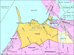
Noyac is located on the South Fork of Long Island in the Town of Southampton. The community is at the edge of Noyac Bay. [7]

The William Cauldwell House was added to the National Register of Historic Places in 2009. [8]

Geography

Noyac is located at 40°59′28″N72°20′4″W / 40.99111°N 72.33444°W / 40.99111; -72.33444 (40.991160, -72.334417). [9]

According to the United States Census Bureau, the Noyac CDP has a total area of 8.7 square miles (22.6 km2), of which 8.4 square miles (21.8 km2) is land and 0.31 square miles (0.8 km2), or 3.70%, is water. [10]

Demographics

Historical population
CensusPop.Note
2020 4,325
U.S. Decennial Census [11]

As of the census [12] of 2000, there were 2,696 people, 1,158 households, and 716 families residing in the CDP. The population density was 383.2 inhabitants per square mile (148.0/km2). There were 1,993 housing units at an average density of 283.3 per square mile (109.4/km2). The racial makeup of the CDP was 95.81% White, 0.96% African American, 0.11% Native American, 0.85% Asian, 0.04% Pacific Islander, 1.45% from other races, and 0.78% from two or more races. Hispanic or Latino of any race were 4.60% of the population.

There were 1,158 households, out of which 25.1% had children under the age of 18 living with them, 51.3% were married couples living together, 6.9% had a female householder with no husband present, and 38.1% were non-families. 30.1% of all households were made up of individuals, and 13.0% had someone living alone who was 65 years of age or older. The average household size was 2.33 and the average family size was 2.92.

In the CDP, the population was spread out, with 21.3% under the age of 18, 4.4% from 18 to 24, 27.3% from 25 to 44, 27.2% from 45 to 64, and 19.8% who were 65 years of age or older. The median age was 44 years. For every 100 females, there were 96.8 males. For every 100 females age 18 and over, there were 93.5 males.

The median income for a household in the CDP was $54,176, and the median income for a family was $66,667. Males had a median income of $53,788 versus $34,167 for females. The per capita income for the CDP was $31,956. About 2.8% of families and 3.9% of the population were below the poverty line, including 5.2% of those under age 18 and 1.9% of those age 65 or over.

Related Research Articles

<span class="mw-page-title-main">West Rancho Dominguez, California</span> Unincorporated community in California, United States

West Rancho Dominguez, formerly known as West Compton, is an unincorporated census-designated place (CDP) located in southern Los Angeles County, California. Per the 2020 census, the population was 24,347. The community lies to the west of the city of Compton. The ZIP Codes encompassing the CDP area are 90220 & 90248.

<span class="mw-page-title-main">Mango, Florida</span> Census-designated place in Florida, United States

Mango is a census-designated place (CDP) in Hillsborough County, Florida, United States. The population was 11,313 at the 2010 census, up from 8,842 at the 2000 census.

<span class="mw-page-title-main">Harlem Heights, Florida</span> Census-designated place in Florida, United States

Harlem Heights is an unincorporated community and census-designated place (CDP) in Lee County, Florida, United States. The population was 1,930 at the 2020 census, down from 1,975 at the 2010 census. It is part of the Cape Coral-Fort Myers, Florida Metropolitan Statistical Area.

<span class="mw-page-title-main">Feather Sound, Florida</span> Census-designated place in Florida, United States

Feather Sound is a census-designated place (CDP) in Pinellas County, Florida, United States. The population was 3,420 at the 2010 census. It includes the St. Petersburg-Clearwater International Airport.

<span class="mw-page-title-main">Georgetown, Chatham County, Georgia</span> Census-designated place in Georgia, United States

Georgetown is a census-designated place (CDP) in Chatham County, Georgia, United States. The population was 11,916 at the 2020 U.S. Census. Georgetown lies across the Little Ogeechee River from Savannah, Georgia, and is a suburban "bedroom community" of Savannah, where most of its adult residents work. It is part of the Savannah Metropolitan Statistical Area.

<span class="mw-page-title-main">Cordova, Maryland</span> Village in Maryland, United States

Cordova is a village in Talbot County, Maryland, United States. The population was 592 at the 2000 census.

<span class="mw-page-title-main">South Gull Lake, Michigan</span> Census-designated place & unincorporated community in Michigan, United States

South Gull Lake is a census-designated place (CDP) in Ross Township, Kalamazoo County, in the U.S. state of Michigan. It includes the unincorporated communities of Yorkville, Gull Lake, and Midland Park and does not have any legal status as an incorporated municipality. The population of the CDP was 1,182 at the 2010 census, down from 1,526 at the 2000 census.

<span class="mw-page-title-main">Millersburg, Michigan</span> Village in Michigan, United States

Millersburg is a village in Presque Isle County of the U.S. state of Michigan. The population was 206 at the 2010 census. The village is within Case Township.

<span class="mw-page-title-main">Beckett, New Jersey</span> Populated place in Gloucester County, New Jersey, US

Beckett is an unincorporated community and census-designated place (CDP) within Logan Township, in Gloucester County, in the U.S. state of New Jersey. As of the 2010 United States Census, the CDP's population was 4,847.

<span class="mw-page-title-main">Concordia, New Jersey</span> Populated place in Middlesex County, New Jersey, US

Concordia is an unincorporated community and census-designated place (CDP) located within Monroe Township, in Middlesex County, in the U.S. state of New Jersey. The CDP is oriented around the age restricted gated community of Concordia. As of the 2010 United States Census, the CDP's population was 3,092.

<span class="mw-page-title-main">Leisure Village, New Jersey</span> Populated place in Ocean County, New Jersey, US

Leisure Village is an unincorporated community and census-designated place (CDP) located within Lakewood Township, in Ocean County, in the U.S. state of New Jersey. As of the 2010 United States Census, the CDP's population was 4,400. The sprawling active adult community is also locally known as "Original" Leisure Village because it was the first of three neighboring active adult communities bearing similar names. Leisure Village East, and Leisure Village West are the other two communities nearby. Original Leisure Village (OLV) is also referred to by the moniker "The Village of Seven Lakes."

<span class="mw-page-title-main">Vista Center, New Jersey</span> Populated place in Ocean County, New Jersey, US

Vista Center is an unincorporated community and census-designated place (CDP) located within Jackson Township in Ocean County, in the U.S. state of New Jersey. As of the 2010 United States Census, the CDP's population was 3,689.

<span class="mw-page-title-main">Rockfish, North Carolina</span> Census-designated place in North Carolina, United States

Rockfish is a census-designated place (CDP) in Hoke County, North Carolina, United States. The population was 3,298 at the 2010 census, up from 2,353 at the 2000 census.

Bonnetsville is a census-designated place (CDP) in Sampson County, North Carolina, United States. The population was 390 at the 2000 census.

Elroy is a town in Wayne County, North Carolina, United States. In 2007, the estimated population was 3,905. It is included in the Goldsboro, North Carolina Metropolitan Statistical Area.

<span class="mw-page-title-main">Northbrook, Ohio</span> Census-designated place in Ohio, United States

Northbrook is a census-designated place (CDP) in Hamilton County, Ohio, United States. The population was 10,912 at the 2020 census.

Whitfield is a census-designated place (CDP) in Berks County, Pennsylvania, United States. The population was 4,733 at the 2010 census.

<span class="mw-page-title-main">Marty, South Dakota</span> CDP in South Dakota, United States

Marty is a census-designated place (CDP) in southern Charles Mix County, South Dakota, United States. The population was 677 at the 2020 census.

<span class="mw-page-title-main">Uvalde Estates, Texas</span> Census-designated place in Texas, United States

Uvalde Estates is a census-designated place (CDP) in Uvalde County, Texas, United States. The population was 2,171 at the 2010 census.

<span class="mw-page-title-main">Hartford City, West Virginia</span> Town in West Virginia, United States

Hartford City, also known as Hartford, is a town in Mason County, West Virginia, United States. The population was 509 at the 2020 census. It is part of the Point Pleasant, WV–OH Micropolitan Statistical Area.

References

  1. "ArcGIS REST Services Directory". United States Census Bureau. Retrieved September 20, 2022.
  2. U.S. Geological Survey Geographic Names Information System: Noyack, New York
  3. e.g. Noyac Golf Club
  4. "Explore Census Data". data.census.gov. Retrieved August 8, 2022.{{cite web}}: CS1 maint: url-status (link)
  5. U.S. Geological Survey Geographic Names Information System: Jessup Neck
  6. Noyac Civic Council 50th Anniversary Newsletter, Retrieved 2010-10-29
  7. U.S. Geological Survey Geographic Names Information System: Noyac Bay
  8. "National Register of Historic Places". WEEKLY LIST OF ACTIONS TAKEN ON PROPERTIES: 5/04/09 THROUGH 5/08/09. National Park Service. May 15, 2009.
  9. "US Gazetteer files: 2010, 2000, and 1990". United States Census Bureau. February 12, 2011. Retrieved April 23, 2011.
  10. "Geographic Identifiers: 2010 Demographic Profile Data (G001): Noyac CDP, New York". U.S. Census Bureau, American Factfinder. Archived from the original on February 12, 2020. Retrieved January 4, 2013.
  11. "Census of Population and Housing". Census.gov. Retrieved June 4, 2016.
  12. "U.S. Census website". United States Census Bureau . Retrieved January 31, 2008.