Calverton, New York

Last updated

Calverton, New York
Grumman-memorial-park.jpg
Grumman Memorial Park
Calverton-ny-map.png
U.S. Census map of Calverton.
Location map Long Island.png
Red pog.svg
Calverton, New York
Location within the state of New York.
USA New York location map.svg
Red pog.svg
Calverton, New York
Calverton, New York (New York)
Usa edcp location map.svg
Red pog.svg
Calverton, New York
Calverton, New York (the United States)
Coordinates: 40°55′14″N72°44′11″W / 40.92056°N 72.73639°W / 40.92056; -72.73639
Country Flag of the United States.svg  United States
State Flag of New York.svg  New York
County Suffolk
Town Brookhaven
Riverhead
Area
[1]
  Total26.71 sq mi (69.19 km2)
  Land26.21 sq mi (67.90 km2)
  Water0.50 sq mi (1.29 km2)
Elevation
30 ft (9 m)
Population
 (2020)
  Total5,934
  Density226.36/sq mi (87.40/km2)
Time zone UTC−05:00 (Eastern Time Zone)
  Summer (DST) UTC−04:00
ZIP Code
11933
Area code(s) 631, 934
FIPS code 36-11781
GNIS feature ID0945505

Calverton is a hamlet and census-designated place (CDP) on eastern Long Island in Suffolk County, New York, United States. The population was 6,510 at the 2010 census. [2]

Contents

Most of Calverton is in the Town of Riverhead, while the area south of the Peconic River is a mostly undeveloped smaller portion in the Town of Brookhaven.

History

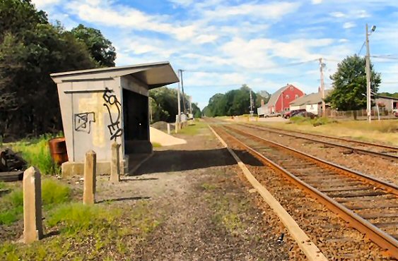
Calverton was first referred to as "Baiting Hollow Station" when the Long Island Rail Road arrived in 1844. The station closed in 1958, but the sheltered shed for the station remained standing as of 2007. [3] [4]

The area's Native American name was Conungum or Kanungum, meaning "fixed line" or "boundary". In 1868, the Calverton post office opened, named for Bernard J. Calvert. It remained a small farming community specializing in cranberries, which grew in swampy areas along the Peconic River until the Navy purchase.

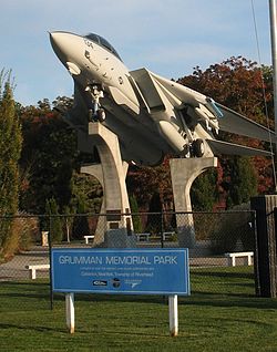
Calverton's history is tied closely to Naval Weapons Industrial Reserve Plant, Calverton. In 1953, the United States Navy purchased 6,000 acres (24 km2) around Calverton from a local farmer named Harry Edwards, including the mansion of a grandson of Frank Winfield Woolworth's, so that Grumman could test and finish jets. A 10,000-foot (3,000 m) runway was built, and most of Grumman's F-14 Tomcat and E-2C Hawkeye aircraft were to pass through the plant.

In 1965, Nelson Rockefeller proposed using the base as the fourth major airport for the New York metropolitan area. Grumman and local opposition ended the quest.

In 1978, more than 1,000 acres (4.0 km2) of the base were used to create Calverton National Cemetery, which is the largest and busiest (in terms of burials per day) United States national cemetery. In 1995, after Northrop acquired Grumman, the new Northrop Grumman pulled out of the base, and the Navy began liquidating the land. In 1996, before the base could be turned over the Town of Riverhead, the base was used to reassemble the wreckage of TWA Flight 800 which had crashed about 20 miles (32 km) south in the ocean. In 2000, Skydive Long Island (formerly located at East Moriches) moved to the airport, and to this day continues to generate the majority of the current air traffic as a key destination for New York–based skydivers.

Through 2007, debates raged about whether or not to turn the base into a mega complex around a NASCAR track, called EPCAL Centre, or a giant ski resort based construction of an artificial 350-foot (110 m) high indoor ski mountain. In January 2008, the Riverhead Town Board, with newly elected officers, signed a deal to sell the airport for $155 million to Riverhead Resorts, to build the ski mountain, tear up the airport runway, and replace it with a lake, overruling a December vote to give the NASCAR track the go-ahead. It would have taken up to three years to get the necessary environmental permits, and the proposed opening date of the project was 2012. [5] On November 12, 2010, however, the town of Riverhead voted 4–1 to cancel all plans for the indoor ski resort/water park. [6]

A portion of the base is being developed as an industrial/office park. [7]

Several new medium size industrial companies have sprung up in the area, including Crown Recycling and a Federal Express Distribution Center.

Geography

According to the United States Census Bureau, the CDP has a total area of 28.5 square miles (74 km2), of which 28.0 square miles (73 km2) is land and 0.5 square miles (1.3 km2), or 1.82%, is water. [8]

The former Naval Weapons Industrial Reserve Plant became the Naval Weapons Industrial Reserve Plant, Calverton (IATA code "CTO") in the late 20th century.

Demographics

Historical population
CensusPop.Note
2020 5,934
U.S. Decennial Census [9]

As of the census [10] of 2000, there were 5,704 people, 2,539 households, and 1,518 families residing in the CDP. The population density was 203.7 inhabitants per square mile (78.6/km2). There were 2,735 housing units at an average density of 97.7 per square mile (37.7/km2). The racial makeup of the CDP was 86.61% White, 7.66% African American, 0.46% Native American, 0.95% Asian, 0.04% Pacific Islander, 2.03% from other races, and 2.26% from two or more races. Hispanic or Latino of any race were 6.07% of the population.

There were 2,539 households, out of which 22.3% had children under the age of 18 living with them, 46.1% were married couples living together, 10.1% had a female householder with no husband present, and 40.2% were non-families. 34.7% of all households were made up of individuals, and 19.9% had someone living alone who was 65 years of age or older. The average household size was 2.24 and the average family size was 2.88.

In the CDP, the population was spread out, with 20.3% under the age of 18, 5.6% from 18 to 24, 27.5% from 25 to 44, 20.9% from 45 to 64, and 25.6% who were 65 years of age or older. The median age was 43 years. For every 100 females, there were 93.0 males. For every 100 females age 18 and over, there were 88.0 males.

The median income for a household in the CDP was $36,544, and the median income for a family was $44,342. Males had a median income of $40,184 versus $33,047 for females. The per capita income for the CDP was $26,609. About 6.5% of families and 10.2% of the population were below the poverty threshold, including 13.1% of those under age 18 and 6.6% of those age 65 or over.

Economy

Splish Splash Water Park is located within the hamlet. [11]

Media

See also

Related Research Articles

<span class="mw-page-title-main">Riverside, Harford County, Maryland</span> Census-designated place in Maryland, United States

Riverside is a census-designated place (CDP) in Harford County, Maryland, United States. The population was 6,425 at the 2010 census. The term "Riverside" is generally used interchangeably with "Belcamp"; both names are accepted for the U.S. Postal Service's ZIP Code of 21017. However, the original community of Belcamp is located south of U.S. Route 40, outside the Riverside CDP.

<span class="mw-page-title-main">Parc, New York</span> Census-designated place in New York, United States

Parc is a location and census-designated place in Clinton County, New York, United States. The name "Parc" is derived from the official name for the 3,447-acre (13.95 km2) industrial site, which is PARC, an acronym for the Plattsburgh Airbase Redevelopment Corporation. PARC was established for the purpose of redeveloping the Plattsburgh Air Force Base after it closed on September 25, 1995. PARC is now operated by the Plattsburgh Air Base Development Authority, and the massive airfield is now Plattsburgh International Airport. The population of the Parc CDP was 254 at the 2010 census. Parc is located in the town of Plattsburgh and is bordered to the north by the city of Plattsburgh.

<span class="mw-page-title-main">Bethpage, New York</span> Hamlet and census-designated place in New York, United States

Bethpage is a hamlet and census-designated place (CDP) located within the Town of Oyster Bay in Nassau County, on Long Island, in New York, United States. The population was 16,658 at the 2020 United States Census.

<span class="mw-page-title-main">Garden City Park, New York</span> Hamlet and census-designated place in New York, United States

Garden City Park is a hamlet and census-designated place (CDP) located in the Town of North Hempstead in Nassau County, on Long Island, in New York, United States. The population was 7,806 at the 2010 census.

<span class="mw-page-title-main">Aquebogue, New York</span> Hamlet and census-designated place in New York, United States

Aquebogue is a census-designated place (CDP) roughly corresponding to the hamlet by the same name in the Town of Riverhead in Suffolk County, on Long Island, in New York, United States. The CDP's population was 2,438 at the 2010 census.

<span class="mw-page-title-main">Baiting Hollow, New York</span> Hamlet and census-designated place in New York, United States

Baiting Hollow is a census-designated place (CDP) roughly corresponding to the hamlet by the same name in the Town of Riverhead in Suffolk County, on Long Island, in New York, United States. The CDP's population was 1,642 at the 2010 census.

<span class="mw-page-title-main">Farmingville, New York</span> Hamlet and census-designated place in New York, United States

Farmingville is a hamlet and census-designated place (CDP) in the Suffolk County town of Brookhaven, New York, United States. The population was 15,481 at the 2010 census.

<span class="mw-page-title-main">Flanders, New York</span> Hamlet and census-designated place in New York, United States

Flanders is a hamlet and a census-designated place (CDP) in Suffolk County, New York, United States. The population was 4,472 at the 2010 census. It is the location of the Big Duck.

<span class="mw-page-title-main">Hampton Bays, New York</span> Hamlet and census-designated place in New York, United States

Hampton Bays is a hamlet and census-designated place (CDP) in the Town of Southampton in Suffolk County, on Long Island, in New York. It is considered as part of the region of Long Island known as The Hamptons. The population was 13,603 at the 2010 census.

<span class="mw-page-title-main">Laurel, New York</span> Hamlet and census-designated place in New York, United States

Laurel is a census-designated place (CDP) roughly corresponding to the hamlet of Laurel in Suffolk County, New York, United States. It is located mostly within the Town of Southold, with a small portion in the Town of Riverhead. The population was 1,394 at the 2010 census.

<span class="mw-page-title-main">Mattituck, New York</span> Hamlet and census-designated place in New York, United States

Mattituck is a hamlet and census-designated place (CDP) in Suffolk County, New York, United States. The population was 4,584 in 2023 according to the World Population Review. Located in the Town of Southold, Mattituck CDP roughly corresponds to the hamlet by the same name.

<span class="mw-page-title-main">Medford, New York</span> Hamlet & census-designated place in New York, United States

Medford is a hamlet and census-designated place (CDP) in the Town of Brookhaven in Suffolk County, on Long Island, in New York, United States. The population was 24,247 at the 2020 census.

<span class="mw-page-title-main">New Suffolk, New York</span> Hamlet and census-designated place in New York, United States

New Suffolk is a census-designated place (CDP) that roughly corresponds to the hamlet by the same name in the Town of Southold in Suffolk County, New York, United States. The CDP's population was 403 as of the 2020 census.

<span class="mw-page-title-main">Peconic, New York</span> Hamlet and census-designated place in New York, United States

Peconic is a census-designated place (CDP) that roughly corresponds to the hamlet by the same name in the Town of Southold in Suffolk County, New York, United States. The CDP population was 683 at the 2010 census.

<span class="mw-page-title-main">Riverside, Suffolk County, New York</span> Hamlet and census-designated place in New York, United States

Riverside is a hamlet and census-designated place (CDP) in Suffolk County, New York, United States. The population was 2,911 at the 2010 census.

<span class="mw-page-title-main">Wading River, New York</span> Hamlet and census-designated place in New York, United States

Wading River is a hamlet and census-designated place (CDP) in Suffolk County, New York, United States, on the North Shore of Long Island. As of the 2010 census, the CDP population was 7,719. It is adjacent to Shoreham and shares a school district.

<span class="mw-page-title-main">Calverton, Maryland</span> Census-designated place in Maryland, United States

Calverton is an unincorporated area and census-designated place located on the boundary between Montgomery and Prince George's counties, Maryland, in the United States. At the 2020 census, it had a population of 17,316.

<span class="mw-page-title-main">Riverhead (CDP), New York</span> Hamlet and census-designated place in New York, United States

Riverhead is a census-designated place (CDP) roughly corresponding to the hamlet by the same name located in the Town of Riverhead in Suffolk County, on Long Island, in New York, United States. The CDP's population was 13,299 at the 2010 census.

<span class="mw-page-title-main">Riverhead, New York</span> Town in New York, United States

Riverhead is a town in Suffolk County, New York, United States, on the north shore of Long Island. Since 1727, Riverhead has been the county seat of Suffolk County, though most county offices are in Hauppauge. As of the 2020 census, the population was 35,902. The town rests on the mouth of the Peconic River, from which it derives its name. The smaller hamlet of Riverhead lies within it, and is the town's principal economic center. The town is 166 miles (267 km) southwest of Boston via the Orient Point-New London Ferry, and is 76 miles (123 km) northeast of New York City.

<span class="mw-page-title-main">Smithtown (CDP), New York</span> Hamlet and census-designated place in New York, United States

Smithtown is a hamlet and census-designated place (CDP) within the Town of Smithtown in Suffolk County, New York. The population was 25,629 at the 2020 census.

References

  1. "ArcGIS REST Services Directory". United States Census Bureau. Retrieved September 20, 2022.
  2. "Geographic Identifiers: 2010 Demographic Profile Data (G001): Calverton CDP, New York". U.S. Census Bureau, American Factfinder. Archived from the original on February 12, 2020. Retrieved December 24, 2012.
  3. "LIRR Shelters". www.trainsarefun.com.
  4. "Calverton LIRR Shelter (August 17, 2007)".
  5. Weir, Richard (September 20, 2007). "Indoor ski plan at Riverhead Mountain gets a big lift". Daily News. New York. Retrieved August 15, 2021.
  6. Winzelberg, David (November 12, 2010). "Riverhead ends ski mountain deal". Long Island Business News. Retrieved August 15, 2021.
  7. "Calverton Enterprise Park". Riverhead, Long Island.
  8. "US Gazetteer files: 2010, 2000, and 1990". United States Census Bureau. February 12, 2011. Retrieved April 23, 2011.
  9. "Census of Population and Housing". Census.gov. Retrieved June 4, 2016.
  10. "U.S. Census website". United States Census Bureau . Retrieved January 31, 2008.
  11. "Contact Us". Splish Splash. Retrieved August 18, 2021.